Southern California, Maui, S. F. Bay Area and the Columbia Gorge see winds in the 20-30 knot range at the same time.
by Mike Godsey
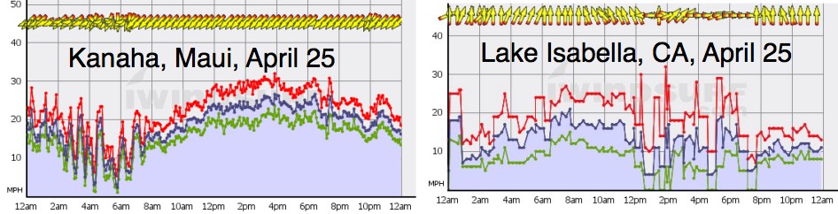
Winds in the Columbia River Gorge in the 20-30 knot range are common. But they are the exception in the S. F. Bay Area and are uncommon most of the season along the Southern California coast. So a day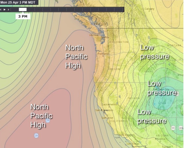 like April 25 when all three venues plus Maui are seeing winds in that range at exactly the same time is a rare event. So let’s look for the causes of this event.
In the next image look at the concentration of isobars around the North Pacific High and the Great Basin low pressure. The tighter the isobars the stronger the pressure gradient and the resulting wind.
The next image shows the overall wind flow resulting from these gradients.
Note the strong NW winds along the entire coast of California from the high. Also note how the NPH’s winds spiral to the SW heading to Maui creating powerful trade winds there April 25.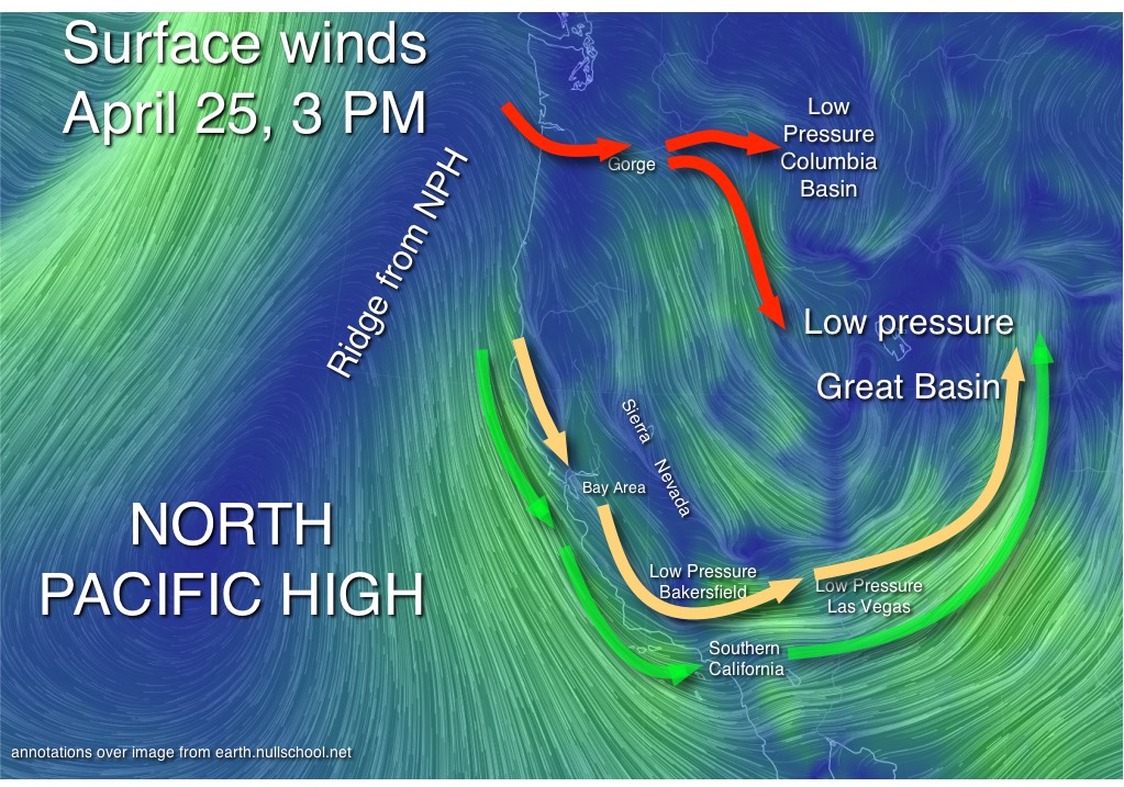
So lets check out each venue in detail.
The Gorge: Note how the North Pacific High’s surface NW winds are relatively weak along the coast of the Pacific Northwest. So clearly the strong Gorge winds were not simply the NW ocean wind curving inland. Now check out the extension of high pressure extending up towards Oregon from the NPH. Such an extension is called a ridge and it produced a high pressure zone just west of the mouth of the Columbia. Meanwhile low pressure had formed in the  Columbia Basin and northern Great Basin and resulted in the wind flow indicated by the red arrows. But notice that the wind lines over the Gorge pale in strength compared to the winds streaming down the California coast. So why were eastern Gorge sites blowing in the 30’s? The answer is that the Cascade mountains form a barrier to that mild wind flow between the high pressure and the low pressure. And the only low point in that barrier is the Gorge so most of the wind concentrates there and a venturi effect comes into play.
Bay Area: Why the Bay Area coast blew is obvious. But 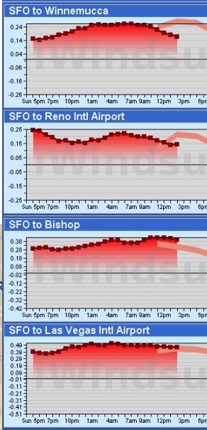 why the strong W to NW winds inside the bay even at sites that normally have WSW/SW wind? Typically the Bay has a pressure gradient to the Central Valley. And that gradient is from SFO to Redding to the North to Bakersfield to the south so the wind coming into the Bay diverges with some wind curving WSW and some WNW. But April 25 almost the entire pressure gradient was focused towards Bakersfield which encouraged most of the wind flowing through gaps in the coast range stream from the NW over the Bay.
But why was the wind so unusually strong and so GUSTY? The primary cause were the winds just aloft. In the next image notice the powerful gusts on the Bay Area hilltops. Such strong wind becomes turbulent as it collides with the hilltops and it transfers momentum to the surface wind making it stronger and gustier. The turbulence also makes the wind shift in unpredictable way as it winds its way around the ridge tops. If you were at the 3rd. Ave. launch site you got a taste of those shifts.
Now look at the pressure graphs to the left. Note that the pressure from the SFO airport to these points in the Great Basin area are almost off the charts. So why didn’t the wind simply blow due east to the Great Basin. Simply put the towering Sierra Nevada act as a barrier to the wind so it has to flow (in yellow) down the state until in encounters the relative low pathway at the southern end of the Sierra. From there it flowed towards the Great Basin low pressure.
Southern California: The southland is a wind paradox. It is very common to see NW winds in the 20-30 knot range just offshore of 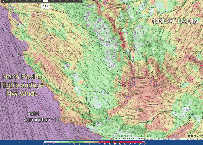 Point Conception where the California makes the kink defines Southern California. Unfortunately the North Pacific High’s surface NW winds don’t readily make a that turn at Point Conception and instead roar across the Southern California bight towards Baja Norte. And often when the NW wind does make the turn it helps form a wind killing Catalina Eddy. But on April 25 the pressure gradient to the Las Vegas and Great Basin region was so strong that the NW wind takes Point Conception like a Porsche 911 Carrera S and blasts into the Southern California coast as WNW wind on its way towards the Great Basin.
In the Gorge a perfect mid summer day is snowboarding at Timberline then kayaking on the White Salmon river then windsurfing or kiteboarding on the Columbia. Perhaps the perfect west coast sailing/kiting day would be doing the Gorge followed by the bay and then jetting to Southern California!