One high pressure creates 4 different
wind patterns
by Mike Godsey, mike@iwindsurf.com
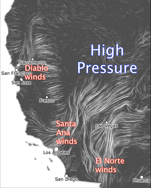
Looking at the video animation to the right you can see strong winds pouring out from high pressure in the Great Basin and 4 corners regions of the USA. To the south note the fame El Norte winds of Baja’s Sea of Cortez. To the southwest notice the Santa Ana winds of Southern California and in the Central Valley and San Francisco Bay Area note the NE winds of the “Diablo winds” While in the Gorge there are 30-40 knot east winds.
Scrolling to the next image look at the Bay Area wind map for the Bay Area at 7:30AM today March 12. Very strong winds are raking the bays sensors from an unusual NE wind direction. And if you looked at sensors on the Southern California ridges and canyons and the northern end of Baja’s Sea of Cortez you would also find powerful wind.
Let’s explore the causes of these winds.
Drop to the third image. Find the high pressure in the Great Basin and 4 corners. This dome of dense cold air creates a high pressure zone compared to
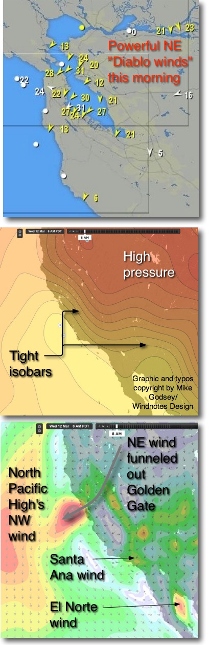 the air over the much warmer ocean waters of Oregon, California and the Sea of Cortez. This is reflected in the isobars or lines of equal pressure that ripple out from the high pressure. The closer these lines are to each other the stronger the pressure gradient and the stronger the resulting wind.
Studying those isobars you can see why there are such strong winds in the Bay Area,
Southern California and N. Baja today. You can also see why the winds fade out before reach Baja’s East Cape so La Ventana windsurfers will not see much action today but larger kites might.
The air moving out from the high pressure is chilly heavy air so as it flows it tends to hug the surface. And when it encounters a mountain range it seeks canyons and gaps in the range. This means there are very local venturi effects in the canyons of Southern California and at the Golden Gate, Fort Cronkite and the Hwy. 92 gap to Half Moon Bay (the airport there recorded 51 knots predawn).
As this air moving from the high pressure moves through the mountains if is flowing down slope. At these high velocities the moving air compresses. And if you remember your gas laws that means if it will warm up. So both Southern California and the Bay Area will be significantly warmer today than typical for mid March. This tends to heat the valleys near the Bay Area and Southern California coasts so the local pressure gradient will climb later today.
This high pressure is typically strongest in the early morning when the air in the Great Basin and 4 corners is coldest at night and in the morning. So this is when the pressure gradient and winds will be strongest. Hence the powerful predawn winds of an El Norte event in the Sea of Cortez or in Southern California. As the air in the Great Basin and 4 corners warms up later today the pressure gradient to the coast and the winds subside. Then given the warmer air in the coastal valleys there may be a wind reversal with local sea breezes from the west.
However it will be hard to get “normal” westerly winds over the mid teens today. Why? Look at the bottom image and find the North Pacific High and its NW winds. Notice how the NE winds blowing out the Golden Gate and over the coast range have blow the North Pacific High far to the west. Once the NE winds subside the North Pacific High’s surface NW winds will move towards the coast but it they are unlikely to reach the shore before dark. But wind wise kiters and windsurfers will watch the sensors anyway. Since if you see the NE winds die early enough the North Pacific High could possibly reach the shoreline. Not likely……