A Bird’s Eye of a Hurricane.
By Shea Gibson
…by WeatherFlow meteorologist Shea Gibson, July 9, 2014.
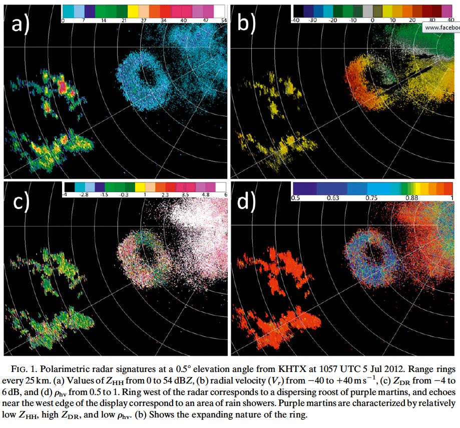
There has been evidence of birds becoming trapped in tropical storms and hurricanes in the past as several species have mysteriously showed up in places where they would not normally inhabit nor breed following these storms. Locations include far inland areas where sea-faring birds have been found. Evolving Doppler technology known as Dual-Polarization Radar or “Dual-Pol” for short, has been successful at catching these birds during their scans.
Below is a typical find in Dual-Pol with birds – as they can tell the size of moving objects captured in the scans. They can even determine what type of bird it is.
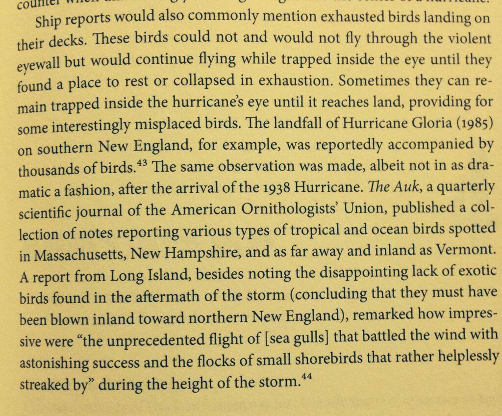
Here is an excerpt from the book “Taken By Storm” (by Lourdes B. Avilés) about The Great New England Storm of 1938…with reference to bird observations and later reference to observations during Hurricane Gloria in 1985.
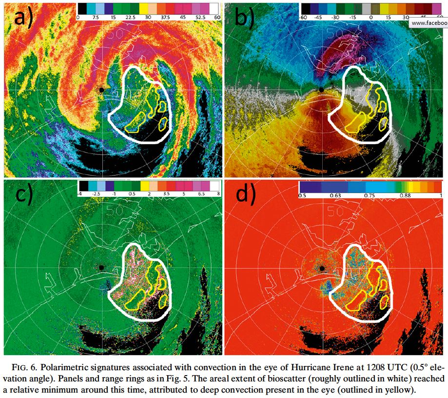
In August, 2011 during Hurricane Irene, this was captured:
NOTE: “While this [bioscatter]may indicate mostly insects that would advect with the background flow rather than strongly flying, the high reflectivity values in these regions (20–401dBZ) indicate many birds are likely present, especially given the lack of observations of significant insect arrival when Hurricane Irene made landfall.” Journal of Atmospheric and Oceanic Technology VOLUME 30 by Van Den Broeke
Recently, UAH Severe Weather Institute Radar and Lightning Laboratories caught this image of birds in the eye of Hurricane Arthur:
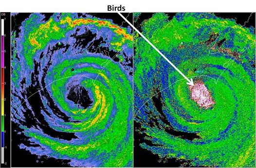
From UAH Severe Weather Institute Radar and Lightning Laboratories:
“The power of dual pol radar. Likely birds trapped in the eye of Hurricane Arthur using reflectivity and ZDR (differential reflectivity)”
From the National Weather Service Wilmington WFO about this image:
“This image of Hurricane Arthur was taken from the Newport/Morehead City radar late in the evening on July 3rd. The left panel is your typical radar reflectivity image. The right panel is a new radar product called “Differential Reflectivity” only available since the upgrade to dual-polarization radar technology. It shows the difference in reflectivity between raindrops measured by a horizontal radar beam versus a vertical one.
Since most raindrops, snowflakes, and hailstones are close to being spherical, differential reflectivity is usually small: 0 to 2 dB. However in the eye of Arthur we see huge differential reflectivity values in the 6 to 7 dB range. What could be that much wider (more reflective horizontally) than vertical?
The answer, we believe, is birds. Hurricanes have been known to trap sea-faring birds in the eye and carry them along with the storm, depositing them hundreds or even thousands of miles from home. Hurricane Hugo back in 1989 took hundreds of seabirds into western North Carolina, depositing them on lakes near Charlotte. There is already one report of Hurricane Arthur depositing a Black Skimmer on a Canadian beach almost 1000 miles from North Carolina: http://thechronicleherald.ca/novascotia/1220822-arthur-blows-rare-bird-into-southern-nova-scotia “
And here is the science behind the theory of birds in the center of hurricanes via PDF: