North Pacific High’s north winds maintain an eddy.
by Mike Godsey, mike@iwindsurf.com
Welcome to July 1994! Like the last several centuries the San Francisco Bay Area is having the normal July SW flow with a deep marine layer! Today that moist chilly blanket is snugging over the hills of Herb Caen’s Bagdad-by-the-Bay. There are many causes of this foggy SW pattern and it is worth studying them since the long range climatological models suggest that these SW patterns will diminish in future decades. Probably by 2110’s NW winds will prevail most of the summer which will radically change the wind pattern in the Bay Area making Waddell and the Peninsula more reliable and Larkspur and parts of Sherman Island less reliable.
This last weeks forecast started off with dire warnings of a heat wave and faint winds everywhere even Sherman Island. Then Monday 14 I had Claire insert a hedge into the weak wind forecast saying that there was a chance that a marine surge would hit that afternoon.
Trying to cover our a$$es I also put a bunch of videos on the iwindsurf.com forum under the title “Weasel Words” that depicted a large eddy evolving in Southern California and quickly moving up to the Bay Area creating SW flow. You should review those Weasel Word videos now to see how we got to where we are now.
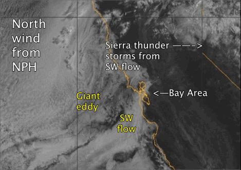
 In this first video you can see what the eddy looked like yesterday in the satellite. First note how the North Pacific High’s wind, on the left edge of the video, is moving from the N. to NNE rather than the typical NW. Notice how this helped create a giant counter-clockwise spinning eddy west of the greater Bay Area. Don’t confuse this with the tiny Golden Gate. This creature spans a hundred
times as much area as the punk eddy.
Now look at the cloud movement near the shore of the Bay Area and note how it is SW. This SW flow tends to bring moist warmer air from the pacific to the south over the chilly near shore waters produced by upwelling. So the moisture condenses and forms fog. This foggy air is attracted to the Central Valley low pressure. However with north winds the most intense low pressure in towards Redding in the northern Central Valley. The means the SW flow is mostly funneled through gaps in the coast range that face SW such as the Hwy. 92 gap, the Sherman Island gap and the Muir gap feeding Larkspur.
You can see this flow pattern more clearly in the 2nd video that shows the modeled wind yesterday. Note how the eddy winds are actually quite weak. But the venturi effect that occurs as they are funneled through gaps jacks up the wind as does the strong pressure gradient to Redding.
Going back to the first satellite image notice how this foggy SW flow disappeared as the air heated and the water vapor evaporated. But check out what happened when this moist air climbed to the cooler elevations of the Sierra Nevada. Thunderstorm time!
Of course the big question is what is making the ocean wind west of the Farallon Islands so northerly. To answer that question we have to look at the big picture. In the 3rd video notice how the NPH is huge and lords over the pacific. But also notice how far to the forth its clockwise spiraling winds are located. This location, west of the Gorge, leaves the Bay Area 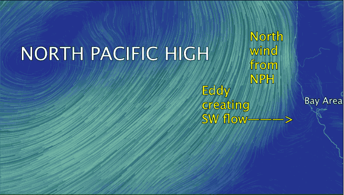 with only N to NNE winds. This means that the ocean waters near the Bay Area shore only have weak wind since they are in the lee of Cape Mendocino and at the Sonoma coast.
These same north winds have to climb over the mountains north of Redding and Sonoma. And as those winds descend to the Central Valley they compress and, remembering the gas laws from your college chemistry class, you know they will heat making a strong low pressure in the northern Central Valley. So as the north ocean winds reach the latitude of the Bay Area they curve in following that pressure gradient and at times even make an eddy. Which in turn makes SW flow in the Bay Area.
Now in 1994 this type of pattern will occur much of the summer. But if you are still around in 2014 people will be saying what went wrong with the weather since they will have gotten used to more NW flow much of the summer.