Heat producing ridge kills most sites but Jones Beach and Bay sites near coast still see wind.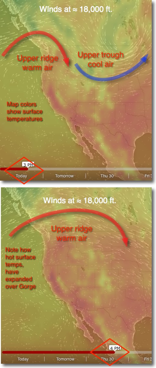
by Mike Godsey, mike@iwindsurf.com
All signs point to a real warm up and light wind forecast for the Gorge and most the S. F. Bay Area for the next 3-5 days. To understand how this results in mostly weak winds let’s start far aloft.
This first graphic shows the upper level winds at about ≈ 18,000 ft. Notice the exiting upper trough that has kept most of the west coast relatively cool the last few days.
Next note the incoming upper ridge. Also note that today the hot surface areas, in red, are most confined to the California Central Valley and the Columbia Basin.
Now look at the second image. You can see that the cool upper trough has exited to the east and the heat producing upper ridge covers much of the western USA. Looking at the surface temps you can see that the hot are has expanded over the Gorge and even into Canada. And if you look carefully you can see that hot air has expanded very close to the Bay Area coast.
OK so we are seeing warmer weather but how does that result in weaker winds. In the area of an upper ridge you have descending air. And as this descending air reaches the surface it compresses and heats. Hence the higher temps is the coming days.
As the surface heats the air expands creating low pressure. Each day as the heating cranks up the low pressure in the Great Basin expands and first comes over the corridor of the Gorge and then over Portland. This means:
1. The marine layer clouds evaporate
2. With low pressure over the Gorge the pressure gradient and winds fade away.
Meanwhile down in California the Central Valley thermal low expands over the Bay Area coast each day.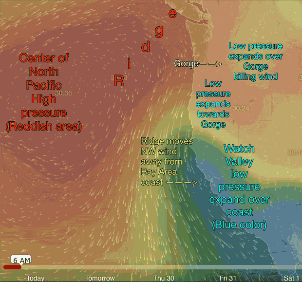
This means:
1. The Bay Area sees a warm up especially inland of the coast.
2. The marine layer clouds evaporate.
3. No pressure gradient in the AM so Sherman Island is dead.
4. The North Pacific High’s surface NW winds are pushed far from the coast so the Bay Area loses that part of the wind machine.
Now let’s drop to the surface and take a look at the action.
In the animated 3rd image find the North Pacific High which is a surface high pressure area in RED. Picture the NPH as a mountain of high pressure air. Typically it is a round to oval mountain of air but sometimes it forms an extension or ridge like you see from a rocky mountain. In this animation you can see each passing day it is pushing a ridge into far Northern California and into the Pacific Northwest.
As it extends this ridge you can see several things happen:
1. Note how the North Pacific High’s surface NW winds move away from the California coast.
2. Notice how the Central Valley thermal low begins to balloon over the California coast leaving a very weak wind zone over the coast.
3. Then watch how the North Pacific High moves towards the Oregon coast and strong N. winds develop.
4. As the days pass watch the low pressure from the California Central Valley expands northward and merges with the Columbia Basin low pressure.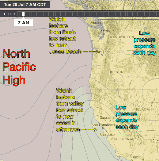
5. Then this low pressure balloons over the Gorge killing the wind.
Why does Jones Beach and sites like Candlestick, Crissy, Coyote and 3rd. Ave. still see wind even during a heat wave?
To forecast winds we look at the concentration of isobars that all of this produces. The last animation shows how the isobars dance around over the next 4 days. This image is a bit complex since the low pressures expand and contract each day with daylight and nighttime.
First let’s look at Jones Beach just west of Portland. Looking carefully you can see the expansion of the Columbia Basin low pressure over the Gorge each day. But in the afternoon you can also see that those isobars pull back to near Portland about the same time as the NPH’s isobars push inland to near Portland. This is a perfect set up for strong winds at Jones.
And in this weird wind summer there is even a chance that this isobar dance could bring some mild wind to the corridor despite all the hot air.
Now look carefully at the isobars near the Bay Area. Each day you can see the Central Valley thermal low expand over the coast. But in the LATE afternoon those isobars retract slightly to right along the Bay Area coast. This means there is a pressure gradient over sites right at the coast. So there is a chance of mild wind at the Stick, Crissy, Coyote and 3rd.