What does a cold front have to do with NW wind?
Yesterday versus Today.
by Mike Godsey, mike@iwindsurf.com
How many times have you seen a graphic like this one on the TV or the web? And you many times have you read in our forecasts that “cold front is approaching” etc?
You must have wondered what exactly does a cold front have to do with wind. So here in graphics and video is the cold front that was approaching the Bay Area yesterday Thursday April 3. And now Friday April 4 @ 8AM this front is passing over the Bay and I am forecasting strong NW wind this afternoon. So let’s take a look at this cold front in general and then from a wind perspective.
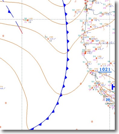
Looking at the first graphic find California and the Bay Area. Notice the blue line with the little points. That is the location of the cold front. To the east of the line is warmer air and southerly wind. to the west is cooler air and NW wind. See how the isobars dip right at the line. This indicates that there is a pressure trough or low pressure in that area.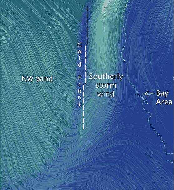
Where the cool and warm air meet at the cold front clouds and showers will form. This often gives the cold front, as seen from a satellite, the appearance of a distinct band of clouds.
Pretty boring so far…. huh? But hang in and see how all of this looks wind wise.
The next 2 videos look at the cold front in motion and the winds and clouds associated with it.
This video is from noon yesterday. Notice the very light winds right at the cold front. To the east of the cold front you can see the southerly storm wind.
Note how weak they were right over the Bay Area. But if you were several hundred miles west of the bay in your yacht you would have had rough conditions.
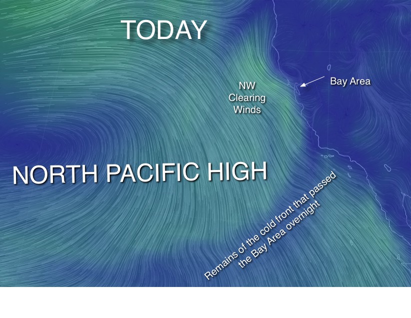
Notice the strong NW wind on the west of the cold front. These are the winds that will be hitting the bay this afternoon.
Part of this NW flow is from the North Pacific High and part is associated with the cold front.
 The winds will be gusty today because above the surface winds you see in the
video there are strong NW winds that will rake the hilltops and stir the surface winds later today.
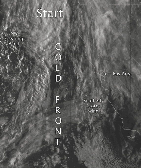
The last video shows the satellite imagery west of California yesterday. In this image you can see the cold front marching towards the California. If you look very carefully you can see the southerly wind and moist air from the storm hitting the Sierra Nevada. Watch as it rises up the mountains, cools, condenses and forms thunder storms.
Now notice the band of clouds in the cold front. That band hit the Bay Area last night and is now passing over us this morning.
Next look to the west of the cold front. Notice that there are far fewer clouds and they are patchy cumulus clouds mixed with mostly clear sky. By mid day you will be seeing these clouds overhead.
Most importantly notice the NW movement of these clouds. This shows the strong NW wind that will fill your kite or sail this afternoon. Now can you see why we call these NW “clearing winds”?
UPDATE @ 11:30 AM
The next image shows the winds patterns in the pacific mid day Friday. Compare the image of the cold front and NW wind above yesterday with the image this image for 11:30 today.
It is amazing how fast the weather picture for the entire pacific can change in 12 hours. Gives you a feeling why forecasting wind is so tricky.
With thanks to http://earth.nullschool.net