Solid wind almost everywhere in the San Francisco Bay Area.
by Mike Godsey, mike@iwindsurf.com
Well yesterday was one of those somewhat uncommon days where kiters and windsurfers at almost 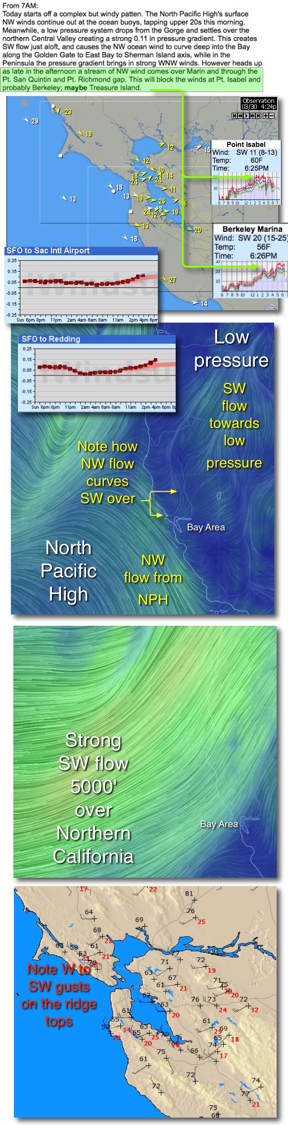 every site in the Bay Area had plenty of power. Wind savvy readers know that when my forecast headline mentions “Combo of NW and SW flow” you can expect a day like you see in the wind map in the top image.
Notice in the map how almost every site in the bay had at least upper teens winds with some well into the 20’s.
Looking at the ocean buoys you can see winds in the upper teens to upper 20’s so there is no question where the NW flow came from with a robust North Pacific High pressed against the coast.
And the first small graph showing the SFO-SAC pressure gradient shows why that NW wind was sucked into the Bay.
But normally on a NW day the winds is focused mostly on the coast and in the Crissy to Treasure Island to 3rd triangle. So why did the East Bay and Sherman Island blow?
Looking at the next image find the North Pacific High and its surface NW winds. Then look at the tiny pressure gradient graph and notice the SFO-Redding gradient skyrocketing around 4PM. Then notice in the upper right corner the low pressure area and the SW flow of wind heading towards that low pressure.
Now the tricky part… squint your eyes and look at the wind flow over the North Bay at the yellow arrows. Notice how the NW wind see north of the Golden Gate makes a dramatic curve turning SW and heading towards that low pressure near Redding.
This means SW flow over parts of the North Bay and East Bay while the coast and Peninsula receive more W to NW flow. And SW flow helps the strong NW wind curve into the Golden Gate to East Bay to Sherman Island corridor.
But there is more to this SW story. In the next image we are looking at the strong SW flow aloft from a storm system passing to the north. Find the Bay Area in the image. Then check out the the strong SW winds aloft.
There is little connection between the NW winds on the surface and these strong SW winds. However when these SW winds graze the high ridges about the Bay Area creating some turbulence that transfers some momentum to the surface winds. This adds a gusty shifty factor for sites depending upon NW wind but it also jazzes up the SW wind for sites favored by SW flow like Pt. Isabel, Berkeley and Sherman Island.
Now scroll back up to the forecast text and notice the part in green. Why, as you can see in the forecast text and the Pt. Isabel and Berkeley wind graphs was the wind so unreliable in those zone when it was fairly steady elsewhere?
That will be a topic for future blog but if you can guess the answer mail me at mike@iwindsurf.com and if you are right you will get a free personalized San Carlos, La Ventana or Gorge forecast on your next trip.