Watch as Cut-Off Low opens up into an upper trough then exits the West Coast.
You are used to hearing about the passing upper trough that pass over the west coast and occasional upper ridges that bob around from the Great Basin. These upper features are upper winds wind around the earth. When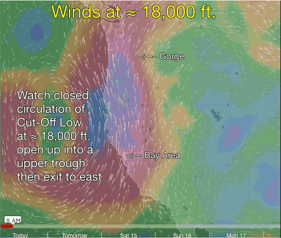 these winds loop southward they allow warmer air and low pressure from the south come over the Bay Area and the Gorge. And they may also allow surface low pressures to develop. Either way they tend to push the North Pacific High away from the Northern California coast so the NW winds fade.
Rarely the loops of upper troughs become very tight loops which may pinch off from rest of the upper level winds leaving a counter-clockwise spinning mass of air at ≈ 18,000 ft. that is known as a Cut-Off Low. Since a Cut-Off Low is disconnected from the overall flow of upper wind from west to east the Cut-Off Low meanders about to our west. And this disconnect makes the trajectory of the Cut-Off Low very difficult to forecast.
The current Cut-Off Low has meant that the Bay Area has had less than optimal winds south of the Bay Bridge for several days while most sites in the Gorge have had weak or unsettled up and down winds. In the Bay Area this has been caused by several surface low pressure spawned by the Cut-Off Low while in the Gorge the issue has been unstable air and moisture aloft.
The Cut-Off Low at ≈ 18,000 ft. which has been responsible for this situation can be seen ejecting eastward in this video. Once this Cut-Off Low departs we should see more season typical winds in both the Gorge and the Bay Area.