by WeatherFlow meteorologist Shea Gibson
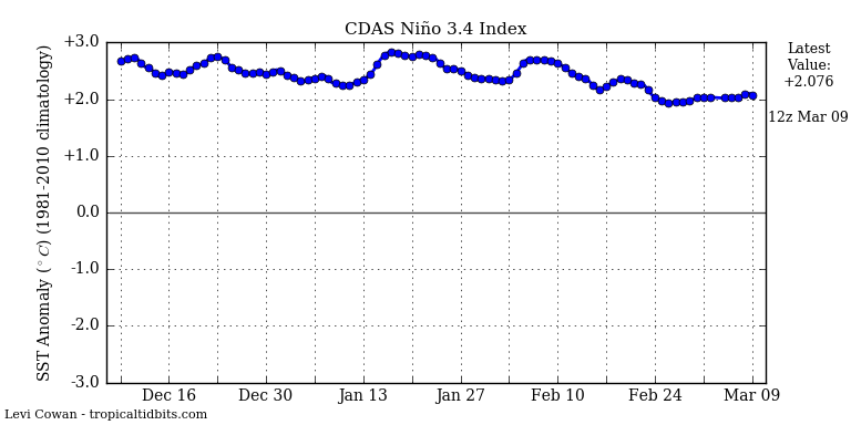
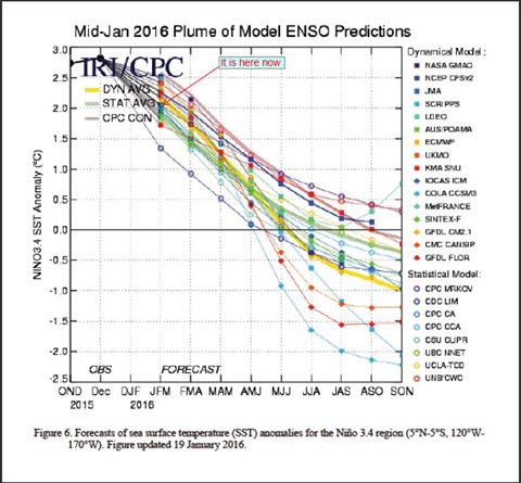
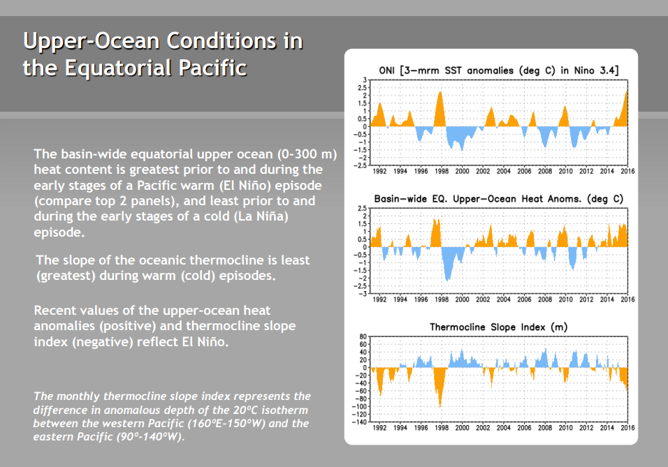
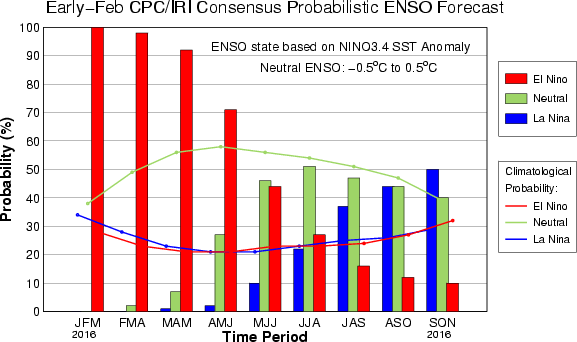
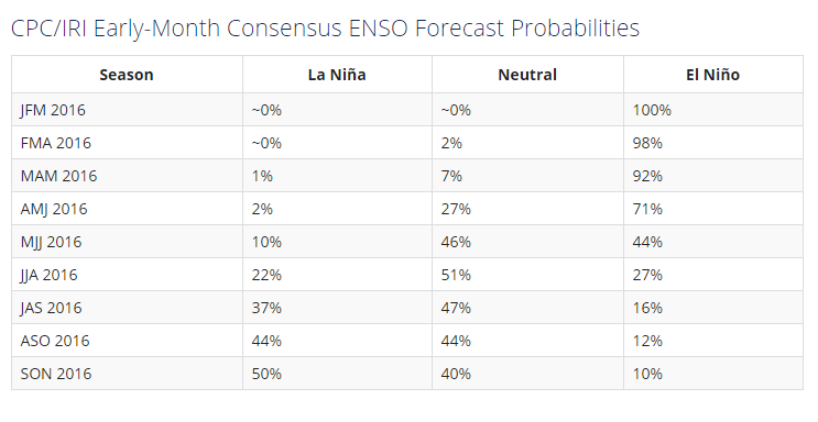
Oceanic Niño Index (ONI) values suggest that El Nino region 3.4 is cooling. Current anomalic value is at +2.076, which means that El Nino is now showing signs of weakening as Sea Surface Temps there have fallen the lowest since August 2015. The prediction is for SST’s continuing to fall, with Neutral phasing on the horizon and possible La Niña phasing by mid summer.
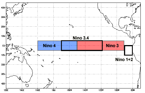
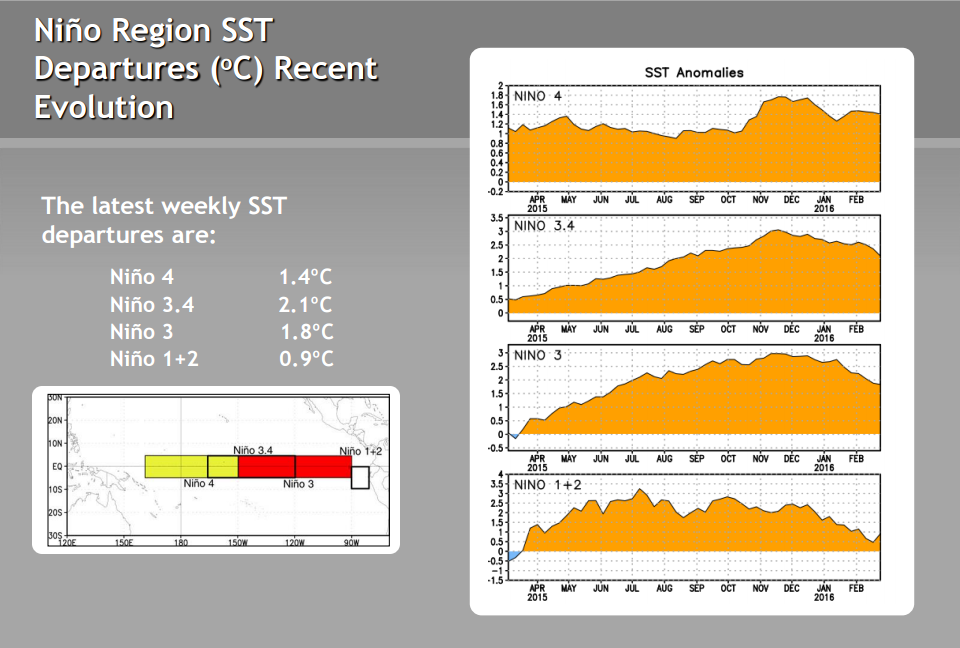
Nino 4

Nino 3.4
Nino 3
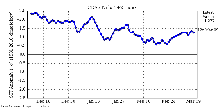
Nino 1 + 2
Looks like more than half of the dynamical/statistical models show below normal temps by the JJA (June, July, August) period, with several showing La Niña values. This could mean that our peak tropical season in September may be more active if the Atlantic basin’s response allows for it. Keep in mind it takes +/-0.5C to classify anomalous phasing.
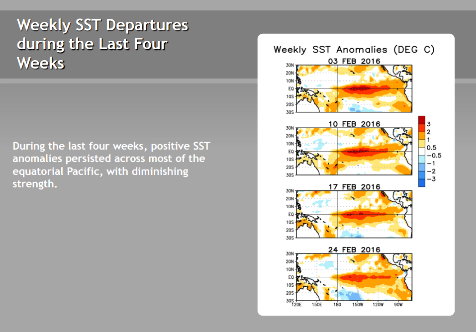
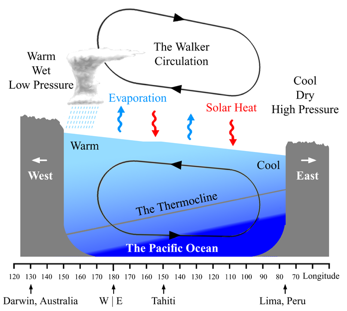
Thermocline starting to push east again, depth decreases and subsurface temps cool. Less warm water upwelling from the thicker warmer surface layer. Much will be dependent on low level atmospheric winds to push neutral phasing. Easterly trades can speed up this process with cool water upwelling.
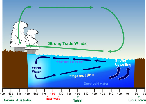
Walker Circulation increases Easterly trades (over confined shallow warmer than normal temps), which eventually cool the surface during decreased depth of the thermocline.
North Atlantic Oscillation per http://www.cpc.ncep.noaa.gov/data/teledoc/nao.shtml :
The positive phase of the NAO reflects below-normal heights and pressure across the high latitudes of the North Atlantic and above-normal heights and pressure over the central North Atlantic, the eastern United States and western Europe. The negative phase reflects an opposite pattern of height and pressure anomalies over these regions. Both phases of the NAO are associated with basin-wide changes in the intensity and location of the North Atlantic jet stream and storm track, and in large-scale modulations of the normal patterns of zonal and meridional heat and moisture transport (Hurrell 1995), which in turn results in changes in temperature and precipitation patterns often extending from eastern North America to western and central Europe (Walker and Bliss 1932, van Loon and Rogers 1978, Rogers and van Loon 1979).
Strong positive phases of the NAO tend to be associated with above-average temperatures in the eastern United States and across northern Europe and below-average temperatures in Greenland and oftentimes across southern Europe and the Middle East. They are also associated with above-average precipitation over northern Europe and Scandinavia in winter, and below-average precipitation over southern and central Europe. Opposite patterns of temperature and precipitation anomalies are typically observed during strong negative phases of the NAO. During particularly prolonged periods dominated by one particular phase of the NAO, anomalous height and temperature patterns are also often seen extending well into central Russia and north-central Siberia.
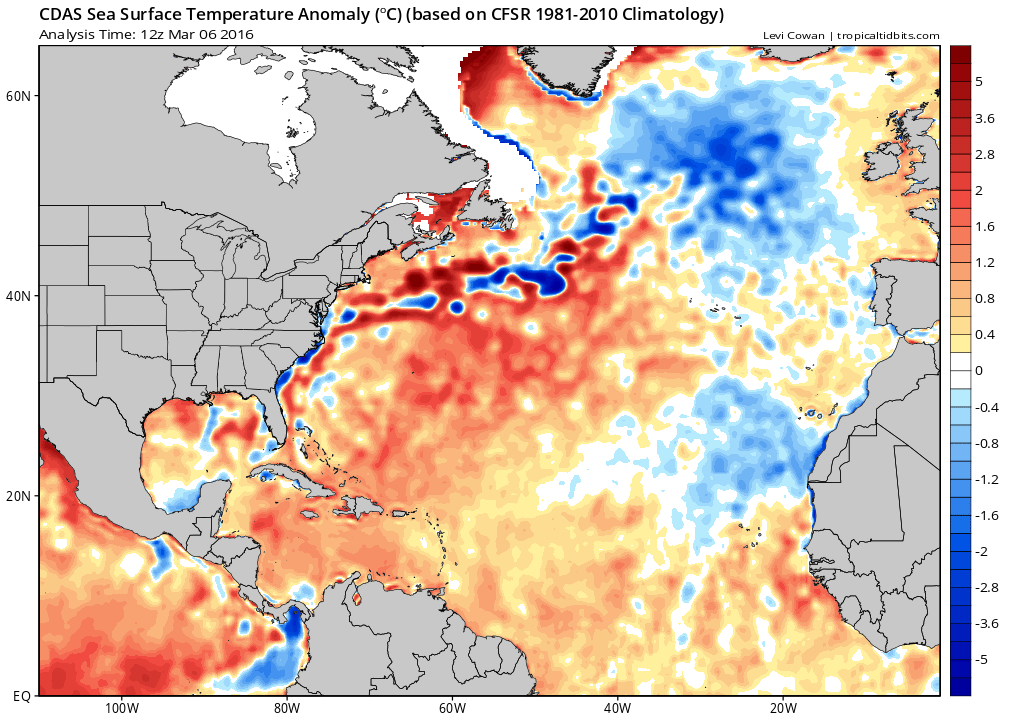
So, let’s take a look at latest Atlantic SST anomalies. As for the Atlantic Multidecadal Oscillation (AMO), we have been in a warm phase since the mid 90’s. We are seeing somewhat of a cooler negative or near neutral AMO due to areas the tropics being below normal. Cooler tropics promotes troughing and continued cooling, whereas the ridging to the north keeps the warmer SST’s locked up there.
We have had mainly a + NAO for this winter. Looks to continue through spring? Here are the numbers from October 2015 through Feb 2016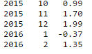
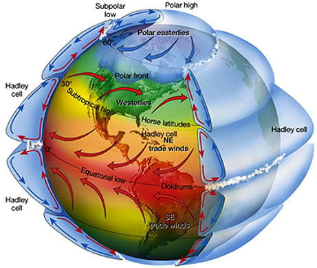
Last time we had a – NAO coming out of winter and a warmer Tropical Atlantic was 2010 where we had a total of 19 storms. The Hadley Cell was able to promote stronger Easterly trades as a result of warmer SST’s and enhanced convection.

This pattern is similar to 1973 and 1983 where La Nina came when the Atlantic was cooler along the tropics- there was limited activity.
Interdecadal Pacific Tripole:
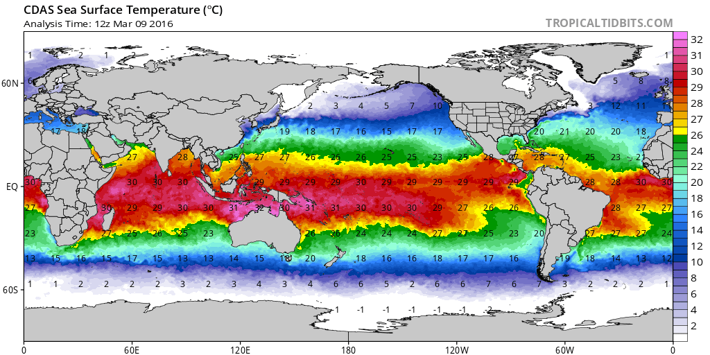
Current Global SST’s
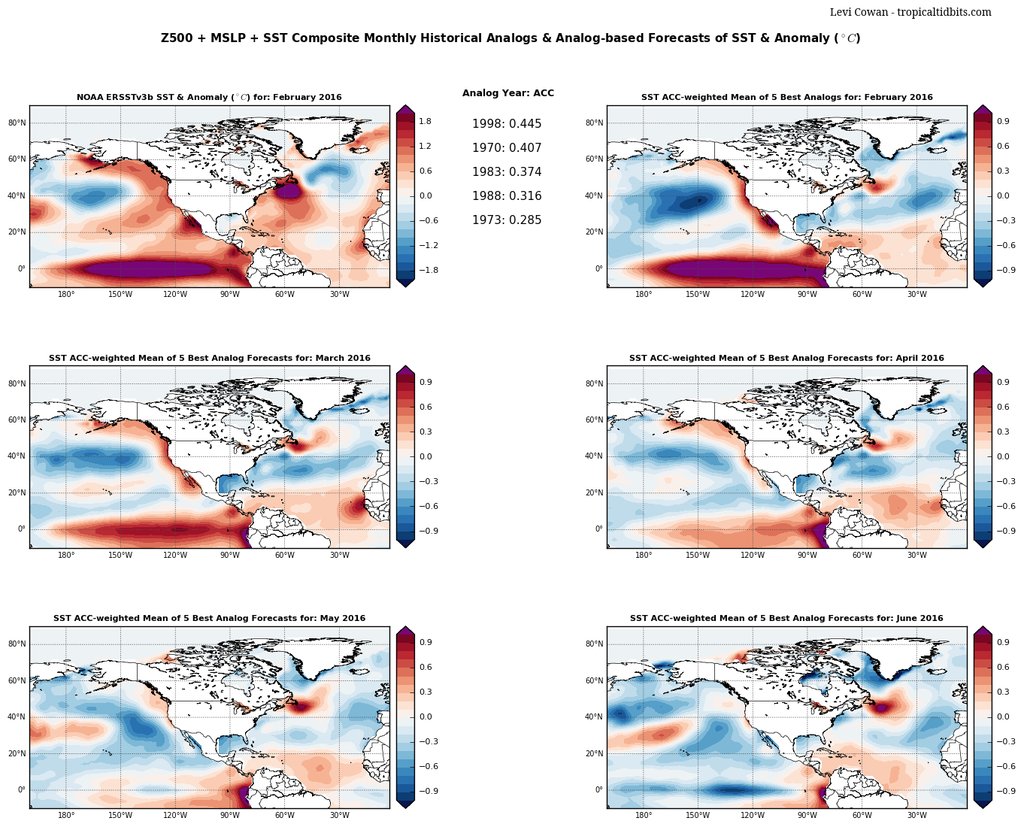
Current outlook- analogues from Feb agree with -ENSO by June. Notice the drops in Nino regions from April to May.
What does this mean for us along the SE Region/East Coast?
Mean the Bermuda Azores ridge will likely remain further north and stay over the Mid Atlantic waters for spring, then retreat and become a weaker Azores feature with far ridging effects to the west. Hadley Cell will be convectively weaker (cooler), resulting Easterly trades weaker and the Ferrell Cell will be cooler. This also suggests warmer surface SST’s will remainn pooled up in the Mid Atlantic and northwards as the Gulf Stream keeps that surface warmth going. High pressures moving west to east across the CONUS likely to have more numerous, yet brief promoting effects for the S/SW Sea Breezing from OBX up through Delmarva and into parts of New York.
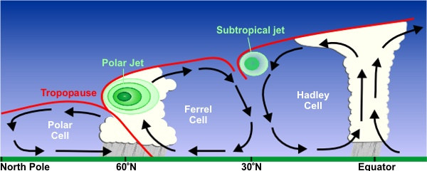
To the south along SC/GA, we could see the ridge axis falling over these two states more often vs the typical central to northern FL axis zone. This would create an overall weaker doldrum-like pattern for much of the SE Region with undulating fronts and Northeast Gulf of Mexico High’s to keep the moisture pulling in and along the boundaries. This creates a warmer, wetter and more humid environment. It does, however, allow for some chances of home grown systems to develop along the Eastern seaboard, especially earlier on before Easterly trades increase during the hottest months. Upper shear looks to be fairly relaxed with the occasional belting overhead from the subtropical jet stream off the SE Coast. Placement of the jet looks to be west to east just over the Horse Latitudes. Rex block setups will be crucial here for faster development along the Gulf Stream. Areas to watch will be SC/NC coastal / offshore zones. Steering pattern will be the mid Atlantic states in accordance with the expanded northern Bermuda High blocking patterns.
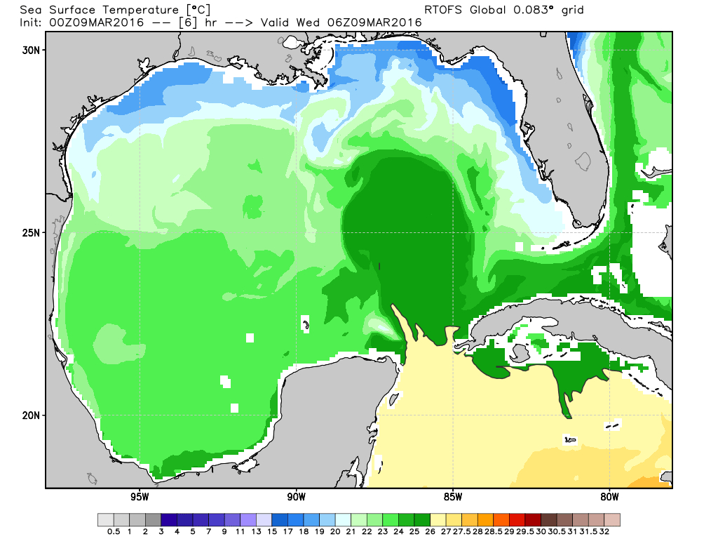
One extra note: The Gulf of Mexico has yet to show signs of significant warming from Easterly trade winds supplementing warm surface waters from the east. We do, however, see a warm water plume beginning to stream in some warmer waters between Cuba and the Yucatan Peninsula.