By Meteorologist Kerry Anderson
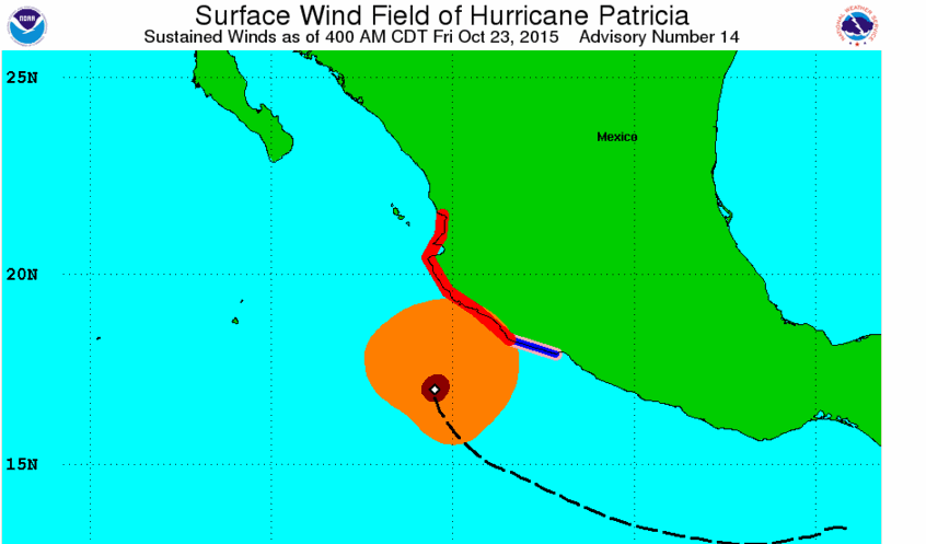
My forecast shift at Weatherflow ended on a Tuesday. Just 72 hours ago I made sure to check the Mexican Tropics to see if there was any possibility of a storm that might develop that could bring sub tropical moisture up into Southern California. There was a small disturbance that the National Hurricane Center (NHC) gave a good chance of development. I checked the models and there was nothing significant expected and nothing that would affect my forecast area and so I finished my shift and didn’t think anything more about the Mexican Tropics. Guess how shocked I was to come back to work and see one of the most powerful Hurricanes had developed from that small disturbance in just 48 hours. As I write Hurricane Patricia is making landfall near Puerta Vallarta, Mexico as a Category 5 storm with wind speeds at an incredible 190 miles an hour. Winds had been estimated by Air Force reconnaissance aircraft to be 200 mph at the peak of the storm with a central pressure of 880 mb.
The following animation shows just how fast this storm blew up. As you can see it wasn’t until 10 am on Wednesday that winds reach above the 39 mph for the storm to be categorized as a Tropical Storm. 24 hours later at 1 pm Thursday the storm barely qualifies as a hurricane. Then in the next 24 hours it explodes into a compact powerful category 5 hurricane that is now moving on shore.
For a hurricane to strengthen it needs a few factors including High pressure aloft and light upper level winds, which Patricia has, but many other tropical storms have these and don’t reach this strength. There will be a lot of analysis once this storm dies as to why it has been able to reach such epic strength. The smoking gun is likely to be the essential ingredient that a hurricane needs to develop and that is warm ocean temperatures and boy do we have that.
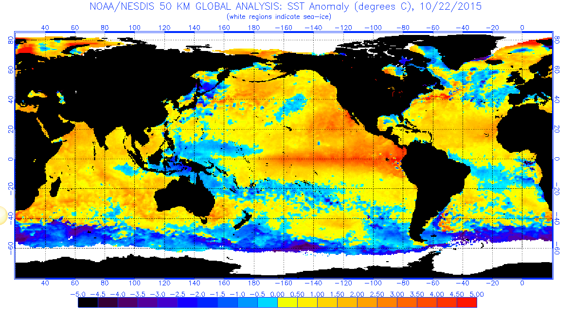
This graphic above shows sea surface temperature “anomalies”. That is the difference from the climatological average. Do you see just how much warmer than normal the ocean is along the Equatorial Pacific? That is the signature of the strong El Nino that is developing.
We are hearing lots about the El Nino here is Southern California as the expectation is that this warm pocket will strengthen the sub tropical jet and send moisture laden storms toward the area this winter. This summer we have seen an above average number of tropical storms and hurricanes in the Eastern Pacific. Hurricanes are named starting with the letter “A”. Patricia starts with a “P” meaning that there have now been 16 tropical storms in the Eastern Pacific while the Atlantic, which is usually the more active area, only has a total of 10.
But the Equatorial Pacific is not the only place that is warm. Take a look again at the map. Do you notice the warm water along the west coast of North America and in many other areas including the a large area in the Northern Pacific?
This year’s El Nino has been compared to the huge El Nino in 1997. The National Climate Center is forecasting a wetter than normal winter for Southern California due to the similarities in the strength of this year’s El Nino to the one in 1997 when Southern California was soaked by winter storms that brought in sub tropical moisture. But maybe that is not the whole story. Yes the Equatorial Pacific’s Sea Surface Temperatures look very similar. Here is how the Sea Surface Temperature Anomalies looked in October of 1997.
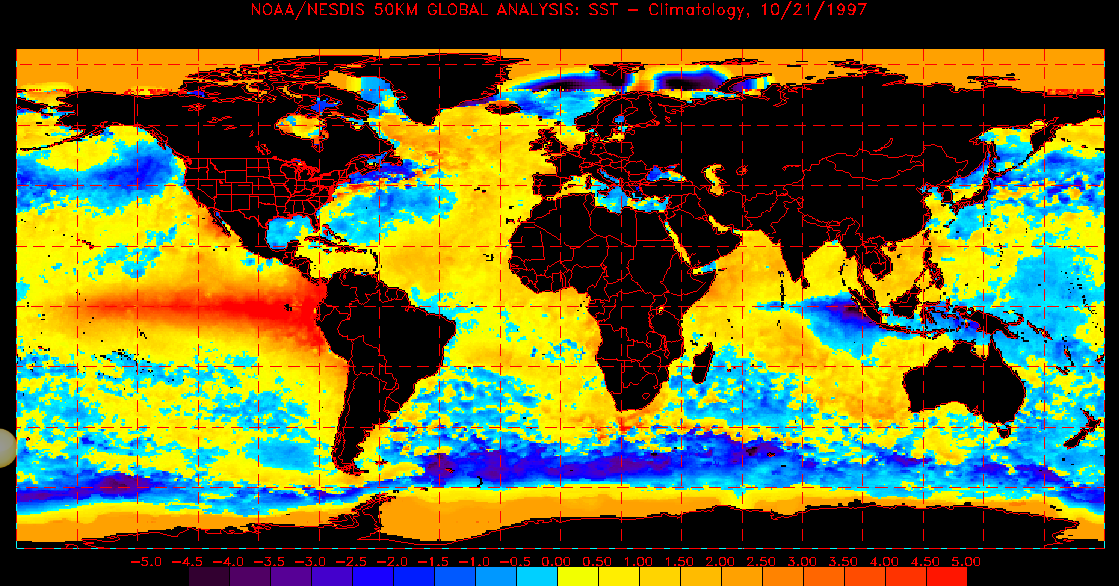
Do you see the differences? In 1997 the Northern Pacific was cooler than normal as were the waters just off the East Coast line. Now in 2015 much of the world’s ocean are warmer than normal. It will be interesting to see how these other pockets of heat interact and affect the development of the sub tropical jet stream this winter. I don’t think we can simply count on the 2015/16 winter to be a cookie cutter of 1997 just because we again have a strong El Nino.