Why Southern California strong WNW winds and Bay Area unreliable SW winds.
by Mike Godsey, mike@iwindsurf.com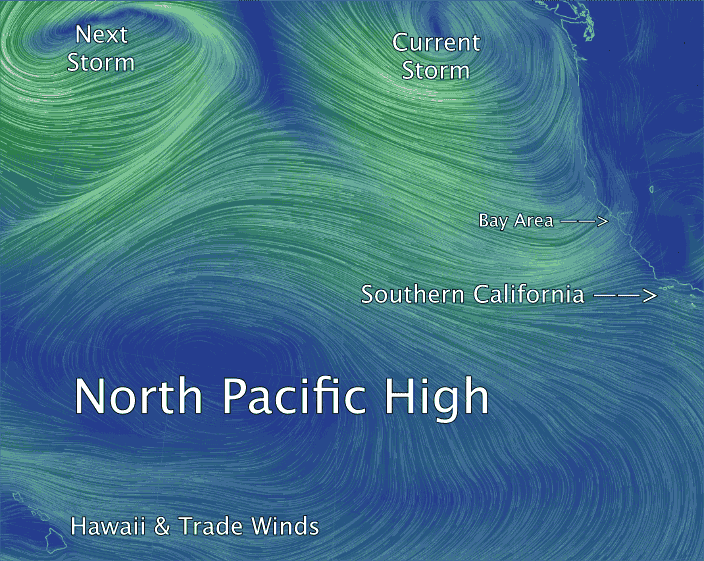
Ever wondered exactly what North Pacific High looks like? Well today in this video of model output the North Pacific High is hard to miss. It is that massive dome of high pressure air between Hawaii and Baja. Note how the wind spirals out from the North Pacific High towards lower pressure areas in a clockwise fashion creating Trades winds in the tropics and NW winds on the west coast.
Looking at the video find the current low pressure storm system dropping out of the Gulf of Alaska. You can also see the modest WSW storm wind that will reach the Bay Area this afternoon.
Now drop to Southern California waters. Check out how the North Pacific High’s surface NW winds turn more westerly as they seek the low pressure in the Great Basin. This makes upper teens to even low 20’s winds likely this afternoon for much of Southern California.
As I mentioned in the last blog the Bay Area normally expects NW clearing winds to ramp up as a storm ejects eastward over California. However looking at the upper left corner of the video you can see a second storm hot on the heels of the current storm. Some time later this wee the North Pacific High will thrust a ridge into that space between the two storms so there is a chance of modest W to NW winds. But that will be a brief event since the next storm will quickly push the NPH southward.
When will the Bay Area finally get solid NW wind… maybe Sunday.
With thanks to http://earth.nullschool.net