Despite an El Nino, a weird winter and abnormally high sea temps the NPH is behaving normally today.
by Mike Godsey, mike@iwindsurf.com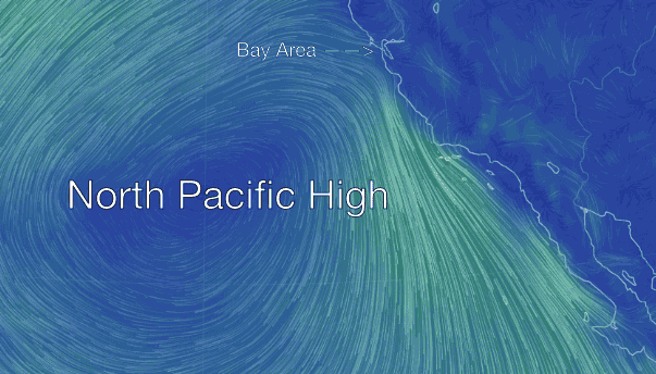
Well this winter saw weird weather in windsurfing triangle from Maui to the Gorge to Baja. And the Bay Area was the epicenter of the weirdness. However today the North Pacific High is positioned in a good location to create moderate NW winds for the entire west coast.
The North Pacific High is a huge mass of high pressure air created as air descends from aloft over the pacific between the west coast and Hawaii. This descending air compacts creates high pressure and then spirals outward from the center in a clockwise fashion. This mean trade winds for Hawaii and NW winds for the California coast. The North Pacific High, especially in the spring, is constantly being shoved around by passing upper trough and surface storm systems so the NW winds come and go as the NPH sometimes leaves our waters. But today there is a lull in those events so North Pacific High is perfectly positioned to keep sending NW wind to the coast from Bodega to San Carlos, Baja Norte. Let’s hope we see a lot more of these days this spring.