Record high temperatures then an early season marine surge.
by Mike Godsey
Working on text.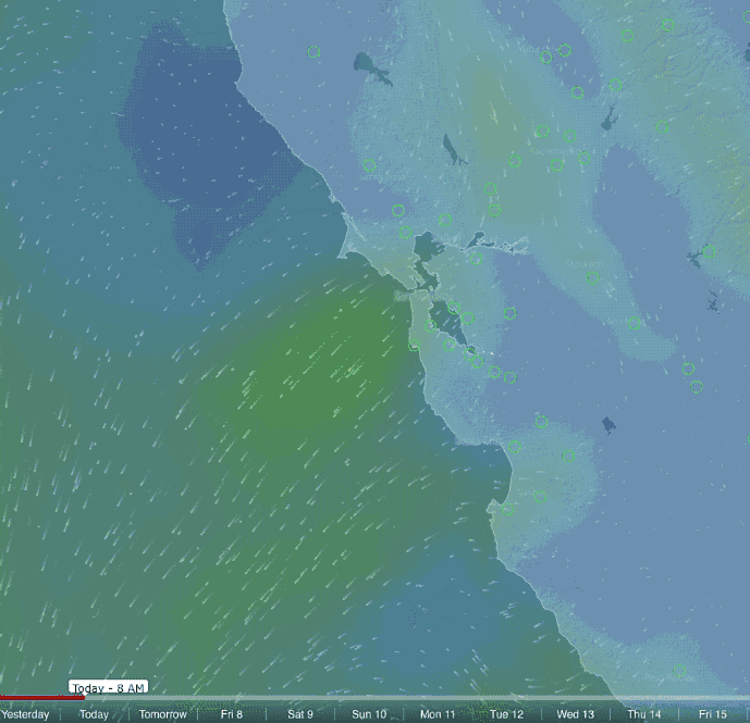
 Today in the Bay Area many all time record temperatures are likely to be broken as the temps move into the low to mid 90’s. Older windsurfing amongst you will remember that 40 years ago heat waves in the Bay Area were a Sept.-Oct phenomena as much of the bay was shrouded in fog most of the summer. Now we have heat waves in April!
Even more puzzling… for most of recorded California history marine surge blasts of SW cool air arrived at the earliest in June. Well as Ben mentioned this last weekend it looks like we will see a marine surge Thursday April 7 as the unseasonal heat wave ends with a chilly bang.
This looks like a big marine surge so expect strong winds in the north tower to Treasure Island to Pt. Isabel/Larkspur to Davis Pt. to Sherman Island corridor. Tigers and possibly Palo Alto have promise.
This is an atypical marine surge. Usually marine surges follow a heat wave. During a heat wave a combo of heating and NE flow causes the Central Valley thermal low to expand over the Bay Area coast. This causes the pressure gradient to the Central Valley to fade away and the winds are very weak over the water. Then as the heat wave fades the Central Valley thermal low retreats back to the valley. This retreat is especially fast right over the cool bay waters but the retreat is much slower over Napa and Sonoma in the North Bay. So a lobe of low pressure remains there after most of the low pressure is back in the Central Valley.
This creates a S. to N. pressure gradient so ocean wind begins sliding up the coast from Southern California. As this air comes into contact with the chilly Northern California waters its moisture condenses creating fog. Since this is now dense heavy air it tends to stick near the surface. So it slides up the coast “seeking” a near water level route to the Central Valley. And when it hits the Golden Gate it accelerates as it finds the low level route all the way to Sherman Island. This means strong wind at sites along that route.
Unfortunately for Coyote and 3rd. Ave. some of this southerly flow filters through the Hwy. 92 gap creating weak offshore winds in that area. Sometimes Palo Alto will paradoxically get NW wind in this pattern as the southerly wind turns towards the relatively warm low pressure air in the San Jose area.
So why is this an atypical marine surge?
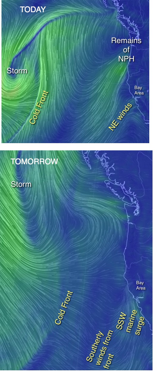
Take a look at the upper image to the right. Notice today there are weak NW winds over the Bay Area. Then note the storm system and cold front away out in the Pacific. By tomorrow that cold front will be close enough to the Bay Area to contribute to the southerly flow. And cold fronts often do not follow the model output exactly. So if this cold front slows overnight the marine surge could partially fizzle.