 How expanding low pressure impacts Southern California,
 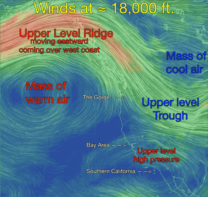 Bay Area and Gorge winds.
“There’s something happening here
What it is ain’t exactly clear”
Buffalo Springfield
Sometimes meteorology seems to jargon ridden to wind seekers that it is hard to figure out what is actually happening. It is hard enough to make sense of all this high pressure and low pressure and pressure gradient gibberish only to find out there are upper high pressures and upper low pressures that also impact the surface winds.
Since the wind will be impacted for the next several days at most west coast sites by upper level high pressure and surface low pressure it is good time to discuss how those factors impact the distribution of the wind.
1. The Gorge is moving into a pattern with very weak winds but Jones Beach closer to the coast BLOWS!
2. The Bay Area transitions into a pattern with mild wind at most sites but Crissy, Candlestick, Coyote and 3rd. Ave. are likely to BLOW!
3. The Southern California beaches BLOW but Belmont and Seal Beach are threatened by the dreaded “Heat Bubble”
Could there possibly be a connection between the wind patterns at sites separated by up to a 1000 miles. You bet! All three venues are going into a heat wave. Looking at this first animation of tomorrow weather pattern you can see the causes of the heating. First remember that the winds you are seeing in the animation are up at ≈ 18,000 ft. or more technically the 500mb level. 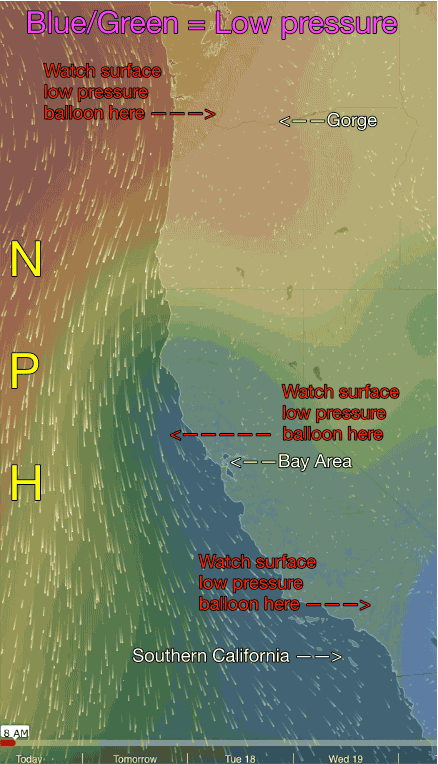 What is important is what these wind patterns do to the surface temps. First note the Upper Level Trough that is exiting to the east taking the recent cool air with it.
Then note the Upper Level Ridge that is moving eastward coming over the western USA. As it comes over us this Upper Level Ridge brings warm higher pressure air over the west coast. Also note the clockwise spinning Upper Level High over Southern California which will bring hearing to the inland valleys and Southern California deserts.
At this point you may be thinking “I don’t care about heat I am looking for wind” Let me connect the dots: all the heat from these upper level high pressure systems tends to focus in the interior areas far from the cooling effect of the Pacific. This is especially true for valleys since there is less wind circulation in a valley. So the California Central Valley, the Columbia Basin, the Great Basin and the Southern California deserts begin to cook with an upper ridge aloft.
As the valley land cooks it heats up the surface air. This causes the surface air to expand and rise creating low pressure. So far this sounds promising for wind since we all know that low pressure is critical for creating strong wind. The problem is that with an Upper Level Ridge overhead there is so much surface heating that the expanding air balloons beyond the basins or valleys towards the coast and once it comes over the sailing and kiting sites the pressure is low both in the valley and ALSO at the sailing/kiting sites. So the pressure gradient fades away as does the wind. Let’s see how this ballooning impacts the premiere west coast wind venues:
Bay Area: Looking at this second animation let’s look at the Bay Area first. Notice how the Central Valley thermal low pressure trough in BLUE has expanded over the coast in the AM. This means there is almost no pressure gradient for Bay sites in the AM to mid afternoon. Then notice how the low pressure retracts near the coast in the PM. This means the isobars of the pressure gradient is tightly focused over sites in the Crissy to 3rd Ave. zone. Since the resulting local sea breezes have to move over land they are in wind shadow near shore and focus mostly outside. Meanwhile sites more inland like Pt. Isabel and Sherman Island see only faint wind.
The Gorge: Looking at the animation notice the low pressure, in GREEN, is first confined to the Columbia Basin. But as the Upper Level Ridge comes over the Pacific Northwest notice how the low pressure trough expands over the Gorge and its edge ends up on the Jones’s Beach zone. So each day as the pressure gradient builds in this area the winds ramp up Jones blows while Gorge sites from Stevenson to Three Mile Canyon only see weak winds.
Southern California: With an upper level high pressure overhead the temps in the Southern California deserts and the inland valleys moves towards the century mark. As the land heats the interior low pressure trough deepens and balloons towards the coast. Now things get really tricky. If the low pressure’s isobars stay just at the coast many sites see solid upper teens to even low 20’s wind. But if the low pressure thermal trough (aka “heat bubble”) balloons over the coast the pressure gradient fades and the winds become weak and/or unreliable. Cabrillo is usually protected from the “heat bubble” since it is out on the Palos Verdes Peninsula surrounded by relatively cool water that blocks the “heat bubble”).
So when does normal wind return to the Gorge, the Bay Area and Southern California? Well since the upper level ridge you see in the first image is drifting eastward it will soon depart from the west coast. And when this happens all that heat in the Columbia Basin and California Central Valley will still be there ready to create a powerful pressure gradient as the North Pacific High moves back towards the coast. So I am expecting a SW marine surge towards this coming Friday for the Bay Area. Something similar should happen for the Gorge. While Southern California sees weaker winds as the low pressure moves further away.