
What it means for today’s winds in Southern California, San Francisco Bay Area, California coast, Baja and The Gorge
by Mike Godsey, mikeATiwindsurf.com
Today the North Pacific High is the master of the eastern Pacific from The Gorge to Southern California to Baja to Hawaii. All of these venues will have winds today that are mostly the result of the distribution of the North Pacific High’s isobars.
Remeber that the North Pacific High is a dome-shaped mountain of high-pressure air formed as air from the tropical ITCZ (towards the equator) decends over the eastern Pacific. You have all seen the topographic lines that circle around a terrestrial mountain. These lines around land mountains show lines of equal elevation. And you probably know that where the topographic lines are close together the terrain is very steep or even cliff like if the lines are tightly packed.
So think of the isobars you see around the North Pacific High dome of high pressure as being somewhat similar. But instead of 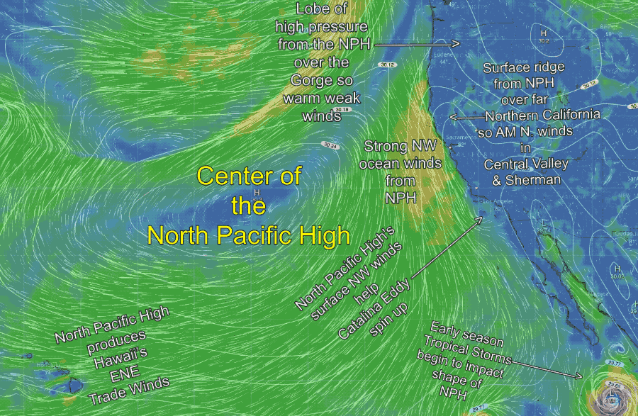 showing elevation they are lines of equal pressure. And the closer the lines are to each other the steeper the pressure gradient and the stronger the winds. And due to the rotation of the earth the winds spiral clockwise outward from the center of the North Pacific High. Notice that the isobars are very far apart in the center of the North Pacific High hence the winds are very weak.
Years ago I used all my scholarship money to buy a tiny sailboat and naively set sail directly from the Golden Gate through the middle of the North Pacific High (NPH? what NPH?) and bobbed around for a week with diminishing water supplies in a glassy pacific getting more and more frightened until the center of the NPH happened to shift northward.
But back to our topic…
Let’s start with Hawaii. Notice that the North Pacific High’s surface winds are NE to ENE near Hawaii. The winds in this part of the North Pacific High are very reliable and came to be called the trade winds in the days of sailing vessels. The isobars are fairly close together today so the winds in Hawaiian waters should be moderate if there is enough heating to coax the winds to the beaches.
The Gorge is the opposite situation today. The North Pacific High has budded off a lobe of high pressure (see the tiny “H” east of the Gorge) this is an area where the air is descending and compressing making for warm, cloudless conditions. And looking at the isobars spacing what would your forecast be for the Gorge today? Hint… think high pressure to the east and cool dense air towards the coast.
Next look at the northern and central California coast. Note that the North Pacific High’s surface NW winds isobars are very close together hence a strong pressure gradient and strong NW winds (in orange). The trouble with the North Pacific High’s surface NW winds is that they are roughly parallel to the coast. This is fine if you sail right at the coast but if you have a cape or land point up winds (think Pismo) or if you are inside a Bay (think San Francisco) you need another pressure gradient to curve the NW ocean winds into your launch site. (think Central Valley)
oday with the weak northerly winds in the Central Valley (as you see in the animation) the moderate pressure gradient near the Bay Area is towards Morgan Hill and Bakersfield so my bet is that most of the winds will be on the coast and from Treasure Island southward into the Peninsula.
Baja Norte is easy since it usually directly receives the North Pacific High’s winds. However notice how the Catalina Eddy is deflecting the wind heading towards San Carlos. So the winds will be iffy at PSC until later this afternoon. And Baja Sur is usually less reliable since the winds of the NPH are curving away from the coast in this area.
And now for Southern California. Sadly, the California coast takes a dive eastward from Jalama to San Diego making for an open bay or Bight. This means the North Pacific High’s surface NW winds scream through the outer Southern California Bight on their way to San Quintin and San Carlos Baja Norte. Worse the Traverse Range north of Santa Barbara creates a localized low-pressure area as the northerly winds hit it. Together these factors often create the wind killing AM Catalina Eddy you see in the animation. So to get the North Pacific High’s surface NW winds to blast apart the eddy and to curve into the Southern California coast you need a strong pressure gradient to a combo of the inland valleys, Southern California deserts and Great Basin.
So in forecasting, we are looking at the location of the North Pacific High which is often over 1500 miles to the west AND pressure gradients to places hundreds of miles away AND the vagaries of local topogrpahy just a few miles upwind of your launch site.