The Gorge Roars while AM eddies rule in the Bay Area and Southern California.
by Mike Godsey
So on a day like today if we had only ONE wind forecast discussion for the entire west coast it might read like this:
“A large North Pacific High spanning the waters from the west coast to N. of Hawaii brings strong winds near the coast. However as the NPH extends a ridge into the Pacific Northwest and far northern California it’s isobars tighten over the Gorge making for very strong winds. At the same time it’s isobars turn W. to E. over Northern California so northerly wind comes down the Central Valley. The ridge also encourages unfavorable NNW winds in the AM just off the California coast and a low pressure trough over the Central California coast and Southern California Bight. This means weak AM winds and an eddy outside the Golden Gate and in the Southern California bight and even near Pismo Beach. These eddies die midday and the winds in California improve.”
Although this discussion sort of looks like English it, by necessity, uses some meteorology jargon.
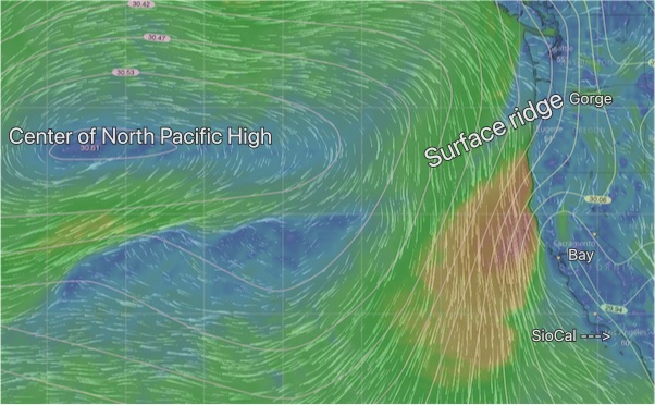
Let’s start to decode this discussion using this imagery. First find the Gorge, Bay and Southern California in the image. Now look about 1000 miles to the west where the center of North Pacific High resides today. The NPH is a dome of high pressure created when air from way aloft descends and compresses creating higher pressure. This higher pressure air then spirals outward in a clockwise fashion which you see in the image above. The white lines are isobars and show areas of equal pressure. The closer the lines are to each other the greater the change in pressure. This is known as a pressure gradient. Notice how the isobars are really tight off the California coast and over the Gorge. The direction of the wind is at an angle to the isobars so the shape of the North Pacific High determines the winds direction unless topography steers the wind.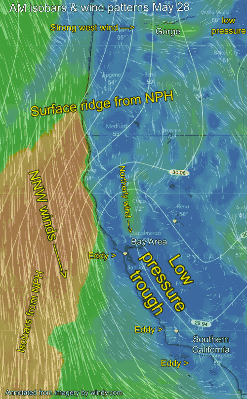
Now notice how the NPH has a bulge over the Pacific Northwest and far Northern California. This is called a surface ridge. In the case of the Gorge the ridge’s isobars run from N. to S. and they are packed close together. However the winds are funneled by the steep topography of the Gorge so the winds is more W. to E. The narrow walls of the Gorge also accelerate the winds.
Next check out the bend in the ridge’s isobars from the surface ridge over Northern California. Note how they are oriented more W. to E. This means there is an N. to S. pressure gradient. This means northerly winds in the Central Valley.
Then check out the angle of the isobars just offshore of Northern California. Notice they are not parallel to the coast (this would promote NW winds) rather than being at an angle to the coast so the wind is more NNW. This angle to the wind is unfavorable since it makes harder for the ocean wind to curve into the Bay Area and the Southern California beaches.
One last variable to note. See the loop in the isobars extending up from Southern California and over the Bay Area and Central California coast? This is a surface low-pressure trough. This will make the AM wind very weak in that area.
The combo of the low-pressure trough and NNW ocean wind tends to cause counter-clockwise spinning eddies to spin just off the Golden Gate and for most of the Southern California Bight.
Today the NPH ridge retreats from over Northern California midday and the low-pressure trough retreats to the Central Valley. If this happens as expected the ocean winds is less NNW and eddies will die. So despite the gloomy start of the wind the winds conditions often improve at select sites.