Forecasting when locally formed clouds are present is very tricky.
by Mike Godsey, mike AT iwindsurf.com
La Ventana and Los Barriles human forecast link: http://wx.ikitesurf.com/proforecast/56
La Ventana is always a tricky place to forecast given the lack of our proprietary 1 and 3 km resolution models and sparse sensor coverage.
But the worse days are when there are sparse clouds in the inland valleys at dawn. If those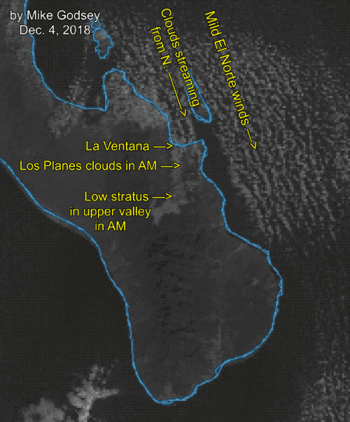 clouds linger the valley does not heat as much and the pressure gradient will be weak.
Today there were mild and fading El Norte winds just offshore and if the valley were to clear it would pull those weak El Norte winds to shore where they would combine with mild local sea breezes. So there was a chance of upper-teens to even over 20 knot winds.
The satellite animation below shows at dawn some fog in the valley that is stationary and streamers of clouds that were forming out to sea east of La Paz and moving into the valleys.
If these were synoptic scale clouds from a storm (like we will see this Thursday) it would have been an easy no wind forecast. But clouds like this are very unpredictable.
So when you see a mention of patchy inland clouds in the forecast your best bet is to watch the clouds to the west. If you see clearing in the late morning expect stronger winds than forecast. If less clearing then expects weaker winds.