
The pacific weather pattern is a mess!
Any veteran windsurfer or kiter, whether from the Gorge, Bay Area, California coast or Southern California or even Hawaii, will attest that this has been a weird summer season. The proximal cause of the atypical winds is the unusual shape and locations of the North Pacific High. In the Bay Area this has resulted in unreliable winds for some sites for some of the normally most reliable sites and an epic season for sites that are typically less reliable. While in the Gorge the winds have been less frequent, weaker, gustier, hotter and briefer than normal. And both Southern California and Hawaii have also seen atypical winds. The ultimate cause of this wind weirdness is a complex interaction between the strange Pacific Heat Blob, the Pacific Decadal Oscillation (PDO) a maturing El Niño and the North Pacific High and its prodigy the Golden Gate eddy. That complex interaction will be the focus of a future blog. Right now I just want to show you today’s weirdness out in the Pacific.
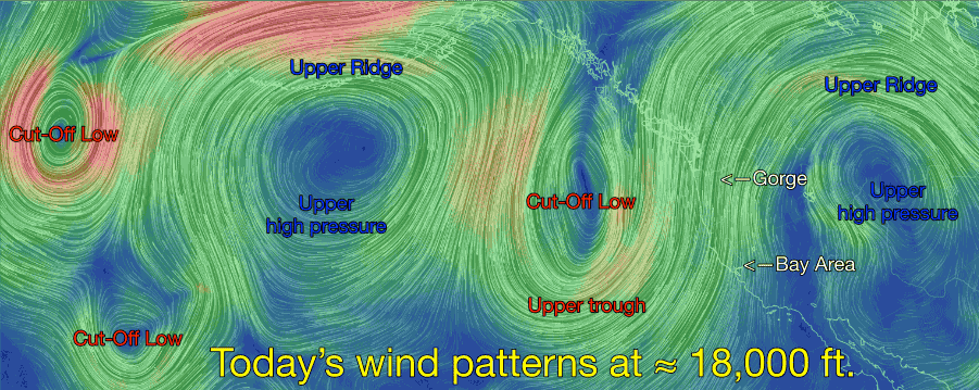
Looking at this first model animation of the winds at the 500mb level at ≈ 18,000 ft. from http://earth.nullschool.net find the Bay Area and The Gorge. The immediate weather maker is the large Cut-Off Low you see just west of the USA. Right now the Cut-Off Low is still connected to its parent upper trough but it looks like it will become complete Cut-Off by tomorrow. Once that happens it will be free to wobble around in the Pacific near the west coast. Look at both the Gorge and the Bay Area extended forecasts and you will see that the forecasters are being unusually wishy washy about the winds the next few days since the fate of any Cut-Off Low is tricky.
The second thing to notice in the animation is the extreme northward and southward extension of the upper troughs and upper ridges. This is something that is becoming much more common in the last decade or so. Why is it important? The air mass within an upper trough is cool air that is extending southward from polar regions so it tends to bring cooler weather. For example the Gorge has been cooler than normal in recent days due to the upper trough you see in the animation. Likewise the air mass in the upper ridges you see in the animation is warm air extending from the tropics. For example Southern California is going through a real warm up due to the upper ridge you see over the USA.
More importantly these greater than normal extensions of the upper troughs and upper ridges also have climatic consequences. In normal times upper troughs and ridges move from west to east over a given point in a few days. So our weather is constantly changing. But when the upper troughs and upper ridges become elongated like you see in the animation they move very slowly over the continents and may even stall for long periods. We saw this happen this last winter when the entire west coast had a very mild winter as an upper ridge lingered over western North America much of the winter. Likewise when an upper trough stalls over a region the winter will be unusually cold. These exaggerated N. and S. extensions of the upper level winds is the main reason you are hearing about more extreme weather patterns in the future.
Oops! we are getting on a side track since our focus is suppose to be wind. So what does all this have to do with wind? Check out the second animation. Notice the “old” North Pacific High. This is the remains of the NPH that has spanned the waters from the coast of the Pacific Northwest to Hawaii the last few weeks. But in recent days it has been battered by storm systems and been greatly distorted and reduced in size. Today it is being crushed against the west coast by a surface storm system. Now glance back at the first animation. Notice that this surface storm is below the Cut-Off Low. This alignment greatly enhances the strength of the surface storm and as it moves towards the coast it will destroy the last remains of the “old” NPH. So Southern California and the Bay Area will lose the NW wind component of their wind machine while the Gorge loses the high pressure critical for making strong wind.
Now look war to the west and you will see a new North Pacific High forming. Once this surface storm crosses the Pacific Northwest this new North Pacific High will move towards the west coast. Normally this would mean NW clearing winds on the California coast. But more storm systems will batter this new NPH and I don’t expect much of it’s NW wind to reach the California coast or to impact the Gorge winds until next Monday or so.