But deep marine layer and SW flow brings weak winds to Southern California and most of the Bay Area!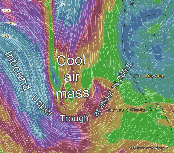
by Mike Godsey, mike AT iwindsurf.com
Low 20’s winds have blown a Sherman Island much of May 23, 2018. We have all learned to expect this when the marine layer is deep and far inland. But what is unusual today is that most of the ocean is clear except near Bodega. Meanwhile most of the Bay Area is socked in.
Likewise in Southern California, the winds will be weak today with clouds lingering over the land while the coast is clearer.
So what is behind this Bay and Southern California wind pattern. And how did Mark know to forecast these winds over a day in advance?
In this first image first, find Southern California and the Bay Area. Then note the southward extending loop of upper-level wind at 500mb at ≈ 18,000 ft.  This loop of wind is known as an upper trough. The air within the loop is relatively cool and the pressure is relatively low.
As this upper trough moves eastward it is bringing cooler air to the west coast and the lower pressure is allowing the marine layer clouds to deepen. Meanwhile, the SW flow you see in the animation extends close to the surface blowing the marine layer clouds far into the Bay Area. The same process is happening in Southern California.
Now check out this satellite animation of marine layer clouds from dawn to mid day May 23.
First, find the Golden Gate. Notice that the deeper marine layer and SW flow from the upper trough sent a broad streamer of marine layer clouds over the Bay Area, across the Central Valley and even over the foothills of the Sierra.
Also, notice how this streamer evaporates as the morning progresses. As the land heats up it makes the fogs water droplets turn into invisible water vapor. Since Sherman Island is the only sea-level pathway for these SW winds it, and to a lesser extent Benicia, are the focus of the strongest winds. Meanwhile, in Southern California, there are similar gaps in the mountains but these gaps are landlocked so only a street kiter could use that strong wind.
Next notice how the marine layer clouds over the ocean become increasingly patchy as the day progresses. This process happens when the air aloft from the marine layer is so deep and the upper trough is so cold that it breaks up the inversion. So paradoxically an upper trough can both deepen the marine layer and also cause it to break up.
Lastly, notice how the ocean winds north to the Bay Area are a bit NNW. This is stirring up some eddies that will keep the North Coast winds weak.