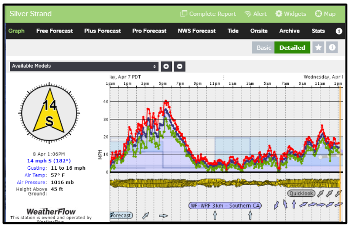
by Meteorologist, Kerry Challoner Anderson Yesterday the models were forecasting some low teens Southerly winds for the San Diego area. I have been around long enough to know that due to the alignment of the mountains to the east of the city, and the funneling effect that they have when the winds turn south that…
by Meteorologist Kerry Anderson This past weekend my husband and I visited Death Valley National Park. How did I miss this gem? I guess the name and reports of the hottest temperatures in the nation don’t exactly make for great PR. But it was awesome. We encountered really strong south winds which of course meant…
by Meteorologist, Kerry Anderson Saturday the wind profile for California’s Central Coast and inside the Bight were dramatically different. Onshore flow increased from Santa Barbara to San Diego cooling temperatures and squelching sea breeze activity. Consequently, winds have been anemic. Meanwhile, the Central Coast beaches spent much the day with winds in the upper teens…
by Meteorologist, Kerry Challoner Anderson The media is talking about a “Bomb Cyclone” on the West Coast. Does this mean imminent destruction? View the following presentation for more info on this very interesting storm and how it relates to all the eddies we had this past summer. https://spark.adobe.com/page/kya0DDY4Zytm3/
by Meteorologist, Kerry Challoner Anderson I have now lived in Southern California for over 20 years and still miss the traditional “fall” weather that is experienced if you lived in a higher latitude. The joke is told though that California has it’s own 4 seasons – Earthquake, Fire, Flood and Drought. If that is the…
by Meteorologist, Kerry Challoner Anderson As we start to move into the heart of fall we expect the North Pacific High to slide further south and that is exactly what we are seeing this weekend and the reason the Central Coast is enjoying such strong winds. Saturday’s pressure maps showed a 1028mb High centered to…
by Meteorologist, Kerry Challoner Anderson The much anticipated first major Santa Ana wind event has begun. Strong offshore winds are typical at this time each year when cold Arctic High-pressure systems move into the Great Basin. This event is very strong. The Tonopah to Los Angeles gradients dropped this morning to -15mb and stays…
by Meteorologist, Kerry Challoner Anderson For days the Southland has been sitting under a late summer upper-level ridge that has been steadily heating the Los Angeles Basin. When this happens we watch carefully to see how close that heat comes to the beaches. Forecasting sea breeze activity is tricky. The strongest winds develop where we…
by Meteorologist, Kerry Challoner Anderson As we recognize the 75th Anniversary of the D-Day invasion it is interesting to look at the role the weather and meteorologists played in the success of the operation. According to How D-Day was Delayed by a Weather Forecast, “The planning team responsible for the invasion of Normandy had to…
by Weatherflow Meteorologist, Kerry Challoner Anderson Last night I was out walking near sunset, checking out the marine layer development north of Santa Cruz, California when I noticed a Kite Surfer struggling to make it back to shore. The winds were quickly fading as the temperature over the land cooled off. High pressure over the…