 Today vs. Tomorrow: The isobars tell the story.
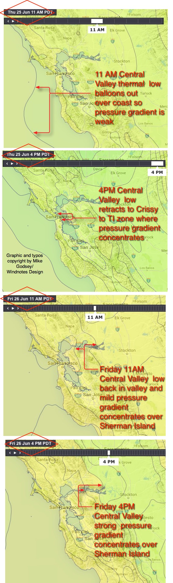
by Mike Godsey, mikeATiwindsurf.com
The 2 key players in the Bay Area summer winds are the North Pacific High’s NW winds and the Central
Valley thermal. Today and especially tomorrow the NW wind are only bit players. So the Central Valley commands the weather stage.
Paradoxically this thermal low can either kill the wind or make it howl depending upon how it’s isobars dance across the map.
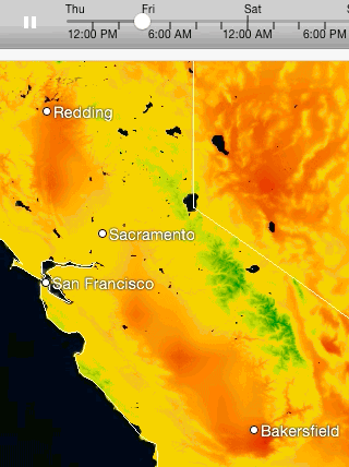
First where does the Central Valley thermal low come from? Looking at this heat animation watch the time line to find the moment of dawn. Notice how the Bay and most of the Central Valley are relatively cool. Now watch how fast the Central Valley heats up. As the land heats it transfers heat to the surrounding air. As this air heats it expands creating lower pressures.
(For weather geeks: One of the questions I get asked most often is why Sherman Island blows in the morning unlike rest of the Bay Area. Or why it sometimes blows all night. If you look at the heat animation very very carefully looking at the temps at night in the Bay Area vs. Redding and Bakersfield you will have the answer. Still at a loss? I will try to explain what is going on in a future blog.)
Since the Central Valley is an landlocked valley it contains this low pressure. The only sea level connection between the cool coastal air and the Central Valley thermal low is the gaps in the coast range around the Bay Area.
When temperatures are in the normal range the isobars of this low pressure are mostly inside the valley and extend a bit towards the Bay. Hence our typical thermal winds as the oceans cool high pressure air flows towards the low pressure in the valley.
Now look at the next image showing the isobars over the Bay Area at 11AM today. In a heat wave the Central Valley thermal low expands and balloons over the Bay and even out into the sea. You can see this in image as a bulge of low pressure going about 3o miles west of the Bay Area.
This bulge causes the pressure gradient to drop to near zero and the Bay winds fade away in the AM. Now look at the second isobar image. By 4PM as the suns angle lowers the low pressure retracts a bit eastward. Today those isobars concentrate in the Crissy to Treasure Island zone hence my forecast for upper teens to 20 knots winds outside for those venues.
Ok, let’s go to the 3rd isobar image for 11AM tomorrow. Notice how different the isobars look. With a marine surge and cool southerly flow coming in from the ocean the Bay cools down. And the isobars are beginning to concentrate over Sherman Island. It this was a normal marine surge the winds will be ripping over Sherman Island at dawn. But I suspect that the inversion will be too strong and the marine layer clouds to shallow for the isobars to really stack over Sherman Island in the AM.
But looking at the 4th image you can see how the isobars tighten over Sherman Island Friday afternoon. Hence my forecast for strong Sherman Island winds Friday afternoon and Saturday.
Now go back to the top animation. Watch carefully how the how air hangs over most of the Bay Area today. Then look how it retreats Friday. That is the cause of the very different wind forecasts for today vs. tomorrow.