by meteorologist Nick Luchetti
In the summertime you’ll almost always see the forecasters at WeatherFlow mention in their forecasts the possibility for afternoon sea breeze development. At first glance, the sea breeze appears to be a simple phenomenon, but forecasting the strength and overall evolution of a sea breeze is quite complex. There are actually several specific geophysical parameters that directly influence sea breeze evolution. The two most influential parameters are the differential heating between the land and water and the synoptic scale wind regime (the overall wind field and whether it is offshore, onshore, or parallel shore).
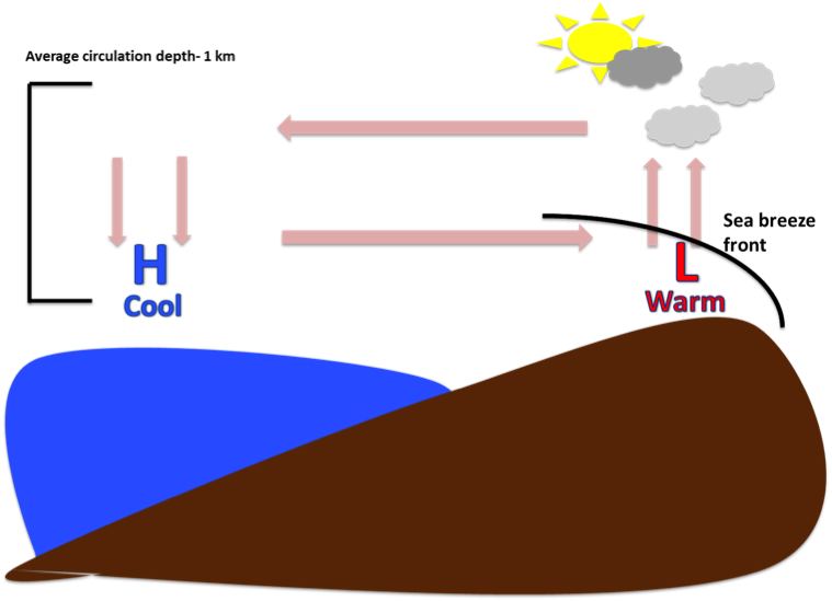 Figure was created by Nick Luchetti
For those who need a quick refresher, the sea breeze is a small scale wind circulation brought about by differential heating between the land and the water. On a hot summer day with little synoptic wind flow, the land heats up faster than the water. This creates a localized pressure gradient where low pressure develops inland and high pressure develops out over the water. Due to the pressure gradient force, wind always blows from high to low pressure. This creates a breeze that flows from the sea , hence “sea breeze”. Ahead of the sea breeze a front can develop and if moisture and instability are present then storms can fire off this front. The average circulation depth is roughly 1 km, which gives you an idea of how localized and mesoscale this phenomenon is.
Where things get interesting is how the overall synoptic wind field regime influence this tiny, localized wind circulation.
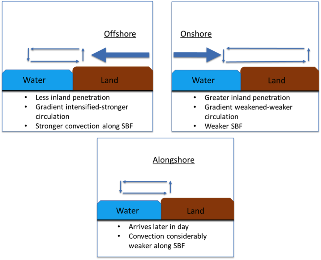 Figure created by Nick Luchetti
Offshore
During offshore flow, the synoptic level winds (usually look at the 925-850mb levels, just above the surface) oppose the sea breeze. This inhibits the sea breeze front’s ability to penetrate inland, which in turn allows the circulation to maintain a strong thermal gradient between the land and water. Because of this, offshore flow induces a strong sea breeze circulation. However, there is a threshold for optimal circulation strength. Offshore winds greater than 14 knots have been shown to significantly weaken sea breeze circulation.
Onshore
During onshore flow, the synoptic level winds flow with the sea breeze. This allows for greater inland penetration. However, the cool ocean air filters in over the land, which in turn weakens the thermal gradient. This aids in a weakening of the sea breeze front. It takes very light onshore winds to maintain sea breeze circulation. It has been observed that winds as light as 2-8 knots can fully suppress a sea breeze.
Parallel
During parallel flow, the synoptic level winds flow alongshore. This aids in a generally weak sea breeze front that tends to stall along the coast. Additionally, we tend to see a later arrival of the sea breeze during parallel flow.
From a forecasting perspective, sea breeze evolution is quite difficult to discern. Models do not do a phenomenal job forecasting this phenomenon. However, understanding how the synoptic level wind flow regime influences the strength and evolution of sea breezes is something forecasters can keep in mind to provide better accuracy in their forecasts.
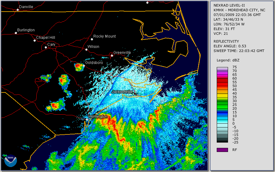
From an observational standpoint, the sea breeze front can be visibly seen on radar reflectivity. You can see on the radar image above a very fine “thin line” that stretches from Wilmington, NC northeast towards Greenville, NC. This visible “thin line” is essentially a collection of insects and dust particles that have been ingested into the updraft along the sea breeze front. During a particular strong sea breeze event, observations have shown inland penetration as far as Raleigh, NC.
Forecasting sea breeze development, evolution, and strength continues to be an enigma for coastal forecasters. However, due to the re-curring nature of sea breezes, observational analysis is highly feasible. As observational and model development increases there is hope that more accurate sea breeze forecasts will be attainable in the future.
References:
(Arrit, 1993; Grisogono et al., 1993; Gilliam et al.,2004, Porson et al., 2007; Crosmen and Horel, 2010)