Way back in June I said in the iwindsurf.com forums:
“Hi jgda, …we are in the early phase of a La Nina pattern. This means wider N-S swings in the pattern of upper trough and upper ridges inbound from the Pacific We will probably have more such swings this summer which in theory means more days out east but UP AND DOWN and unstable clouds in the corridor. Alternating with more heatwaves”
This advice was played out much as described but the last few days have been beyond weird.
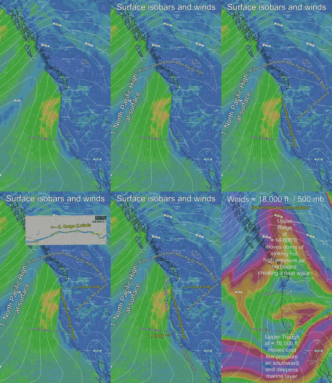
This animation for Sunday July 26 shows the complex that created NORTH WIND for the Oregon coast and SOUTH wind for the California coast. While producing EAST winds for the ENTIRE Columbia River Gorge. And creating a huge counter-clockwise spinning eddy of the greater San Francisco Bay Area.
Let’s look at the factors producing this weirdness:
Usually, the North Pacific High resides west of Oregon. And when the Columbia Basin in eastern Oregon heats it creates low pressure. So strong W. wind funnels and accelerates through the Gorge.
But on July 26 upper-level winds caused the NPH to extend a ridge into the Basin so we had high pressure to our east. As this ridge formed the NPH pulled away from the California and Oregon coast. Then and as an upper ridge heated the Willamette and California Central Valleys a low-pressure trough expanded northward along the coast.
So now the Gorge had high pressure to the east and low pressure to the west. A complete reversal of our normal pressure gradient. As you can see in the animation this created light easterly winds out towards the Wall to 3 Mile Canyon and strong E. wind in the Stevenson to Rooster Rock area.
Typically East winds occur in the Fall and are confined to the Stevenson to Rooster area. They certainly do not reach upper-teens at Doug’s. And East winds are legendary as fan steady winds. Which is not what we saw on July 26.
So, why the less steady winds?
Look at the very end of the animation. Notice how the strong winds at ≈ 18,000 ft. loop northward in what is called an upper ridge. This upper ridge is a mass of descending warm air that becomes even warmer as it compresses during its descent. This produces a heatwave and compacts all the natural and human-made particulates and pollution towards the surface. Hence all the brownish air near the surface. And all hot land around the Gorge tends to rise during heatwaves which make the easterly winds pump up and down.
The mid part of the animation shows how the surface ridge and thermal trough also enhance the North winds on the Oregon Coast. So smart kiters and sailors heeded Matt Sounder’s forecast and headed that way.
The animation goes on to show how the surface ridge and thermal trough do on to produce a counter-clockwise spinning eddy west of the San Francisco Bay Area.
The sad part of this whole story is that this type of eddy has plagued the San Francisco to Waddell coast for weeks. And I know Bay Area kiters and windsurfers who made the long drive to the Gorge to escape the surface ridge and thermal trough produced eddy. Yet in the Gorge, they found that the same surface ridge and thermal trough combo created hot unsteady winds.

