 Video: Why such a large and long lasting Catalina Eddy today?
by Mike Godsey, mike@iwindsurf.com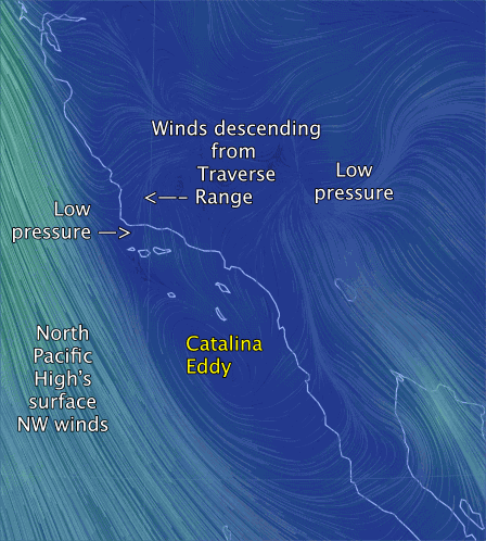
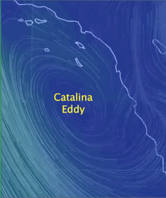
The causes of the Catalina Eddy that so often shuts down Southern California winds while creating weak SSE wind are complex. And one of these days I will do a special blog covering that topic. But today let’s focus on why today’s Catalina Eddy is so huge spanning the waters from Ensenada, Mexico to just north of Jalama near Point Conception.
Looking at the video notice the North Pacific High’s surface NW winds roaring down the northern and central California coasts. Notice the kink in the California coast starting at Point Conception. This turn in the coast means that Southern California is typically in a wind shadow and often does not receive the brunt of the NW wind from the NPH unless there is something to push or pull those NW winds so they curve into the beaches as NW to WSW winds. What type of “something”? One factor would be lots of heat in the inland valleys another would be strong NW winds aloft. Today we have neither.
That sets us up for a Catalina Eddy. Now notice how part of the NW wind north of Pt. Conception curves inland and becomes a northerly wind. This wind climbs the Traverse Range of mountains north of Santa Barbara. As this wind “falls” down the ocean side of the mountain in compresses, heats and expands creating a very local low pressure area. In the early morning there is very little wind in the 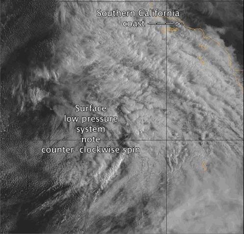 waters around the Channel Islands but this air begins to march towards this low pressure near Santa Barbara creating a southerly wind. But the bulk of the NW ocean wind has to much momentum to make the sharp turn towards the low pressure. However further south the NW wind at the edges of the wind shadow is moving much slower and a bit of this NW wind curves towards the shore and is swept up into the eddy.
On a typical Catalina Eddy day the low pressure area near Santa Barbara is filled in by the eddy wind mid to late morning and the eddy dies. But today the Catalina Eddy is being turbocharged by 2 factors.
1. Look carefully at the video in the area to the right side and notice the wind flow from Baja’s Sea of Cortez and eastern edge of the Catalina Eddy. Note how the wind is rushing towards this low near Las Vegas. This flow is augmenting the eddy and is making it larger and probably longer lasting than a typical Catalina Eddy.
2. Now look at the 2nd video. We are looking at the pacific for hundreds of miles SW of Southern California. First find the coast and the channel islands in the upper right corner. It is in that area that the Catalina Eddy is still spinning at 11:30AM. Now notice the surface low pressure area that has formed below an upper trough at ≈ 18,000 ft. Looking carefully notice the counter-clockwise spin of the clouds around this low pressure. Now look to the waters where the Catalina Eddy spins and you can see that the spin from this huge low pressure system tends or reinforce the counter-clockwise spinning spin of the Catalina Eddy near shore.
This, along with the high clouds overhead, is why the wind forecast for the Southern California coast is so bleak today.