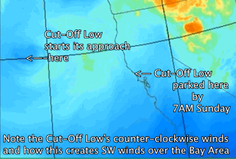
Then Cut-Off Low stops just west of Marin County creating a mild marine surge of SW wind and fog.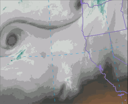
by Mike Godsey, mike@iwindsurf.com
Normally a marine surge of SW foggy cool air can happen to bring a sudden end to a heat wave. But today we have a less typical marine surge that is caused by a Cut-Off Low. What is a Cut-Off Low? Going around the earth at ≈ 18,000 ft. are 3-5 upper troughs and ridges moving from west to east. The upper troughs are southward extending loops in the upper level winds.
Sometimes one of these loops becomes so narrow that the most southward extending part of it pinches off and becomes a counter-clockwise spinning low pressure area. It is now called a Cut-Off Low because it has become disconnected from the main flow of upper level winds. Once you have a Cut-Off Low it becomes very hard to forecast its travel since it is disconnected form the main flow of weather around the globe.
 In this first satellite animation you can see the Cut-Off Low far to the west of California. Note the counter-clockwise flow spiraling out from the center of the Cut-Off Low.
In the second video you can see the Cut-Off Low from a different view. Note how it ends up stationary just west of Marin and Sonoma county on Sunday morning.
The third video takes you on a tour from the surface all the way up to ≈ 18,000 ft. In the first frames you are looking at the surface winds at 7AM today. Notice the strong NNW winds way to the west of the Bay Area. Look carefully in the almost calm area just west of the Golden Gate and you can see the weak  SW winds of the marine surge.
In the second set of frames you are seeing the counter-clockwise spinning winds of the Cut-Off Low at about 5000 feet above the Bay Area. These winds will stir some SW wind on the hilltops later today.
In the 3rd set of frames you are seeing the actual winds of the Cut-Off Low at about ≈ 18,000 ft. These winds are far stronger but do not directly impact the surface winds.