North Pacific High: why the coast and the Gorge ripped yesterday.
by Mike Godsey, mike@iwindsurf.com
let’s take a quick look at the big picture behind yesterdays wind on the Oregon coast and in the Gorge. First, the simple concept of Gorge winds is the pressure gradient between the west and the east. But to forecast the development of that pressure gradient you have to know what causes it to form.
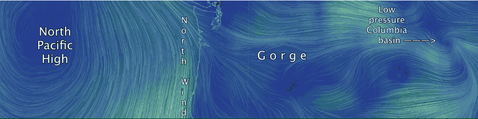
In the top video first find the Oregon coast and the Gorge. Then notice the North Pacific High and the winds that spiral out of in in a clockwise fashion. You can see why in this set up forecasting northerly winds on the coast is pretty easy. Just plot out the future location of the North Pacific High and when it arrives at the coast and you have a decent wind forecast.
But forecasting for the Gorge is much trickier. The North Pacific High’s wind are surface winds and when they hit mountains their flow is disrupted, weakened and changed in direction. That is why on a day like April 11 most sites in inland Oregon and Washington did not show winds remotely like what the coast saw. However the North Pacific High still pushed isobars over the 2 states so there was a pressure gradient. And that pressure gradient was strengthened by low pressure in the Columbia River Basin far to the east. So while the NPH’s wind can not flow smoothly from the N. as on the coast there still is a strong West to East pressure gradient. And as you can see, on the right edge of the video, all that west wind blasted through the Gorge and spirals into the Basin.
Now picture the Gorge being a near sea level gap in all those mountains. The northerly winds will blow over that gap but the pressure gradient will make wind rush from the North Pacific High Pressure towards the low pressure in the Basin. And since the gap is narrow in places you will get a venturi effect further accelerating the WEST wind.
Now looking at the bottom video first find the Gorge and notice the strong WEST wind flow along the river. Now notice that while the northerly flow from the North Pacific
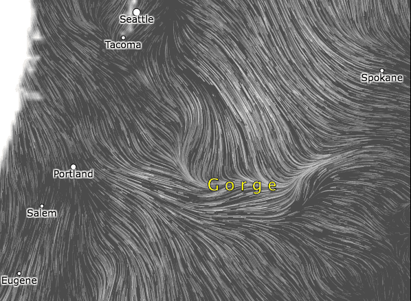
High is disrupted over land it still stirs the surface wind in all the valleys and hilltops of Washington. Look carefully and you can see what happens when this northerly flow reaches the Gorge. Notice how it “feels” the pressure gradient and flows along the path of least resistance eastward in the Gorge.
You experience this northerly flow as wind shifts and powerful gusts and the westerly wind is enhanced by northerly flow curving into the westerly flow. This addition of northerly flow also determines what sites have the strongest winds and even which side of the river has the strongest winds..
With thanks to http://earth.nullschool.net and http://visual.ly/wind-map?view=true