Using the models.
by Mike Godsey, mike@iwindsurf.com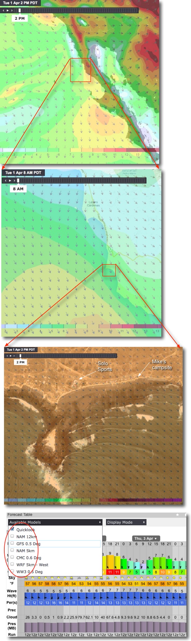
There are 2 problems for using the computer model forecast tables you see all over the web for isolated areas like PSC.
1. None of the models for that area “see” the local thermal wind so you have to add a fudge factor to the models wind velocity.
2. The models break the world into small quadrants and forecast for the average wind in a quadrant. These quadrants can be as small as 1 km to as large as 30 km and all of the models quadrants for the San Carlos area are huge. So often a given launch site will be near the edge of a quadrant that mostly has weak wind so the modeled wind for the site is much lower than reality. Anytime you get a forecast by clicking on a point or looking at a table you run the risk of this type of error.
To avoid this error before making the long drive to San Carlos:
1. Look at a wind map and zoom in and out to see the modeled wind velocity in the overall area of the pacific west of San Carlos.
2. Look at 4-5 different models and check out what each one shows on its version of a wind map.
The images below show some of this data on windalert.com which is free for PSC. Notice how you can zoom out to see the wind approaching the whole Baja coast or zoom in to see the wind near Solo Sports camp site. And you can do this for many models.
You can also click on the map at PSC and out in the pacific nearby to get tables of wind data. Do this for each of the models you see in the red circle.
Then, in late spring & summer, you can get an idea of the unmodeled thermal wind by clicking on the option in WA to show “Satellite & Wind” look for a wedge of fog just north of PSC indicating thermal winds.
Doing all of this will get you a much more accurate forecast than just looking at a table showing a single model forecast on the web.
Have a great trip and remember that the campsite labeled “Mike’s campsite” on the map is reserved.
Here is the link (It may be necessary to click on the “Regional Products” and then “Forecast Maps”)
http://windalert.com/en-us/Search/ViewResults.aspx#29.981,-115.751,9,2