High pressure over the western USA sends moist air above the west coast.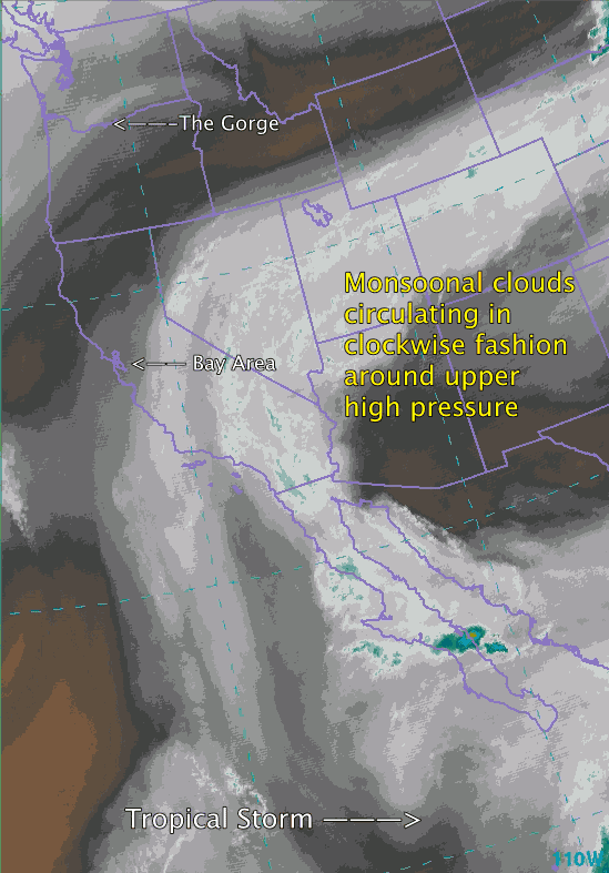
by Mike Godsey, mike@iwindsurf.com
Several times each summer the exotic phrase “Monsoonal Clouds” appears in the forecast. For some of you the phrase is just greek for others it triggers vague memories of something to do with India. If you are a Vietnam vet the phrase conjures up memories of sudden massive downpours that endure for months on end. But I bet all of you wonder what the hell monsoons have to do with your wind.
First some background.
Often times in the summer a large upper level high pressure develop over the western interior of the USA at ≈ 18,000 ft. feet. This normally heats up the California Central Valley, the Great Basin, Southern California deserts and the Columbia Basin that are one of the engines of west coast winds. This heating causes the air at the surface to expand creating a thermal low pressure area. Now if this low pressure stays put it enhances the wind at all the west coast windsurfing and kiting venues since the pressure gradient deepens.
But if the upper high pressure is really strong and lingers the thermal low in these valleys begins to expands and since each of these valleys has a mountain range to the east the thermal low expands westward towards the coast. If it stops expanding before the coast there will still be good wend at more westward locations at each of these venires. So the Hatch, Crissy and Cabrillo can still blow during a moderate heat wave.
However if the upper high pressure is really intense the low pressure balloons completely over the west coast so the pressure gradient fades away as does the wind. So Southern California, the Bay Area and the Gorge will be windless until the upper high pressure drifts away.
Where does Monsoonal Flow come from?
Video #1. We are looking at the western USA from a satellite tuned to detect water vapor molecules above 10,000 feet. Notice the clockwise flow of clouds around the upper high pressure over the western USA. Occasionally, like today, this clockwise circulation pulls in tropical moisture from Baja’s Sea of Cortez and the Gulf of Mexico. You can see this moisture as grayish clouds moving in form the SE over the west coast. This type of moist tropical air is known as monsoonal moisture. Notice how this monsoonal moisture first hit Southern California, then Northern California and finally the Gorge.
These high clouds decrease the amount of sunlight hitting each of the valleys that are critical for generating the west coasts thermal winds. Cooler temps in these valleys mean weaker pressure gradients in Southern California, The Gorge and the Bay Area. Most of this monsoonal moisture is in the form of invisible, to the human eye, water vapor. But when it hits a mountain range the air cools and forms clouds that may range from pearly high clouds to massive thunderstorms. Looking at the video you can see thunderstorms forming over Arizona and the Southern California deserts this morning. Now look at the Northern California part of the Central Valley and notice how it is blanketed by high clouds this morning. If these persists this afternoon they will spoilt the pressure gradient. Now look towards the Gorge and see how they are moving into the Columbia Basin. Once again if they linger the pressure gradient will be limited.
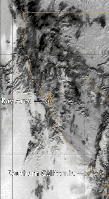
Video #2. Did you notice how much my forecast for the Bay Area changed in the last 24 hours. What happened to the promised 2nd. day of the marine surge? Here is the problem . Since it is almost impossible to determine exactly where monsoonal clouds will form and drop the pressure gradient forecasting becomes extremely difficult. This is why during monsoonal flow you may see the forecast change fast. And the winds may be much stronger that forecast if the clouds do not form or dissipate. Or the winds could be much weaker than forecast if the clouds become more extensive.
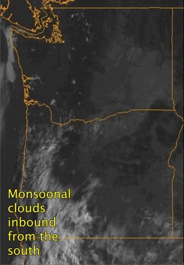
Video #3 The Gorge was also impacted by these clouds. As they arrived and and made a t him high blanket over much of the region the pressure gradient ramp up was dulled and even the Hatch only saw 5.5 winds.