
All from chilly high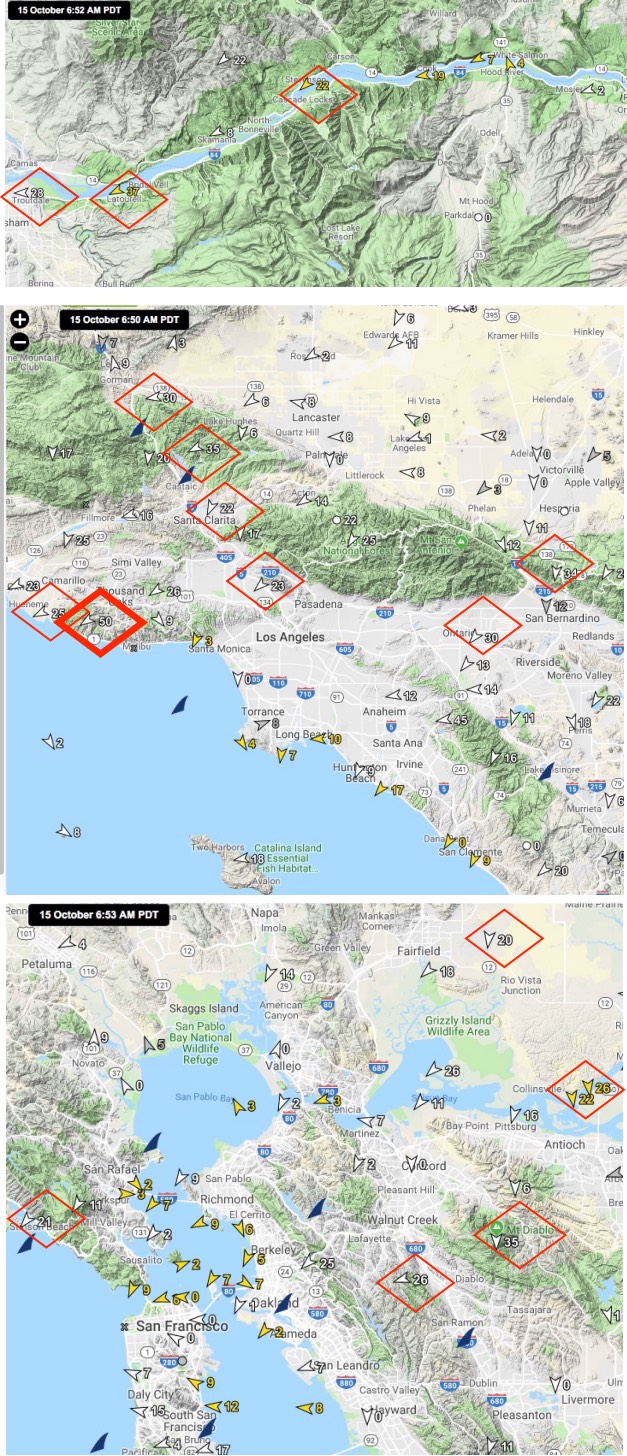 pressure in the
Great Basin area!
A glance at the NWS technical discussions above tells you that localized big wind events are the story for Southern California, San Francisco Bay Area and the Gorge this morning.
Also, notice the mention of compressional heating and the winds fading in the afternoon.
First, check out the Gorge map to the right. Notice that sites to the east have weak while the Rooster Rock area has winds averaging in the upper 30’s.
But curiously the winds all around those sites are mostly weak.
Next, notice the mid 30’s Santa Ana winds in the passes and canyons of Southern California. Especially note that Pt. Mugu near Malibu is averaging 50 knots.
Yet once again many sites in Southern California barely have a trace of wind.
Lastly, look at the San Francisco area map. Again notice that the very strong winds are highly localized. Sherman Island is seeing northerly winds in the 20’s, Stinson has dawn winds to the low 20’s while Mt. Diablo wind is averaging 35 this morning.
These winds are sometimes called Diablo wind in the Bay Area for this reason.
Strong El Norte winds are also blowing down the northern Sea of Cortez in Baja and San Felipe, Baja.
Likewise, brisk southerly winds are blowing into the Canadian Rockies while northerly wind are blowing in Oklahoma and Texas.
So where is all this wind coming from? Also, why do the Southern California, Baja and the Bay Area have such cool names for their N to E winds like Diablo, Santa Ana and El Norte while Gorge folks, uncreatively, just call east winds… East Winds? So I hereby propose that we call these east wind Rooster winds since Rooster Rock is where the usually are strongest. Of course, we could c all them C–k winds since that was the rocks name before the early days of political correctness.
After that digression… The next animation shows the main causal factor behind all this wind. First note the huge dome of surface high pressure that spans the Great Basin, Columbia Basin and into the Great Plains. This mass of chilly dense air has higher pressure that all the surrounding areas.
Note the white isobar lines that define the high pressure. The closer the isobars lines are to each other the stronger the change in pressure over that area. ie. the stronger the pressure gradient. Notice how the isobars are tightest over the Gorge, near the Bay Area and Southern California. Hence the strong wind in those zones. Likewise, there are tight isobars towards Canada and Okalohoma. While Baja has fairly loose isobars so this is a very mild El Norte event.
Typically the winds you see in this animation will weaken after midday. This is because the air in the Great Basin begins to warm and is less dense so the high pressure weakens.
It is important to realize that overall these winds are really not that strong. But they do span huge areas. So when all that relatively slow-moving air encounters a mountain range it concentrates in the gaps, canyons and passes and accelerates.
This is why the winds are strong at Rooster Rock and in Southern California passes and places just downwind from the those passes. While most of us think as venturis as occurring at a gap in a mountain range the effect can also happen when winds run along a mountain range. Hence the El Norte and Sherman Island winds.