
Upper trough departs and upper ridge steers NPH towards California.
by Mike Godsey, mike AT iwindsurf.com
You Sherman Island fans have had good to great WSW winds the last several days. But for rest of the Bay Area and Southern California, the winds have mostly been weak WSW to SW with a nagging marine layer. Meanwhile, our extended forecasts have consistently mentioned building NW ocean winds this coming weekend.
The animation below spans the Pacific from just north of Hawaii to California. Get yourself oriented by finding Southern California and the Bay Area on the right side.
The animation starts showing the surface isobars (lines of equal pressure) and the surface wind for today Thursday, May 24. Notice the sparsity of isobars and winds in the Pacific near California today. This means weak winds along the coast.
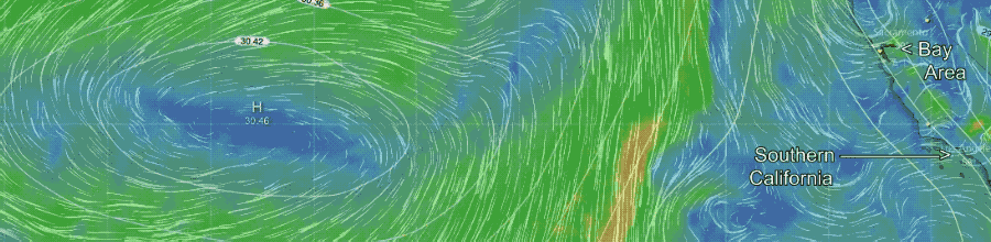
Now check out how the center of the North Pacific High moves much closer to California Saturday and how the isobars tighten and the NW winds crank on the coast. So far this does not appear to be major NW event since some of the other variables will not be perfect. Still, it will be a welcome change for those who loath SW flow and thrive on NW flow.
Still, the question remains, what caused all this SW flow and deeper marine layer and why do we switch to NW flow on Saturday.
The answers are way aloft in the 500 MB. level (remember that sea level pressure is about 1000 MB). The height of the 500 Mb. fluctuates but averages ≈ 18,000 ft. The winds at this level snake around the globe with northward extending loops of warmer air called upper ridges and the southward extending loops of cooler air called upper troughs. These upper ridges and troughs are critical since they steer and augment the surface lows and highs that make the winds that fill our sails and kites.
Now look at this second animation which shows the winds at ≈ 18,000 ft. AND the surface isobars so we can compare the two.
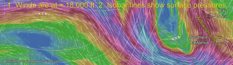
Notice how that today, Thursday, May 24, there is a strong upper trough just off the west coast. This upper trough is the major factor in our recent wind patterns in the Bay Area and Southern California winds. A summer upper trough near the coast does several things: 1. It allows the marine layer to deepen but the clouds may mix out if they become too deep due to cold air aloft. 2. creates SW flow aloft that sends the marine layer further inland. 3. brings cooler air inland. 4. often encourages a counter-clockwise spinning low-pressure system to develop offshore creating mild SW ocean winds. 5. often it promotes thunderstorm in the Sierra. 6. rarely it can also bring scattered showers near the coast.
Now looking at the same animation for Saturday, May 26 notice how the upper trough is exiting eastward over Nevada while the upper ridge lunges towards the coast. This acts to steer the surface North Pacific High’s surface NW winds closer to the California coast and brings NW winds aloft over California. So, strange as it might seem, the accuracy of my Southern California and Bay Area forecast for this weekend hinges on events almost 3 miles aloft.