
Timing is everything!
by Mike Godsey, mike AT iwindsurf.com
I avoid forecasting for the Gorge for a number of reasons. The two biggest reasons are that it takes about 2-4 years of forecasting in a new
area to learn how to interpret all the model output and empirical data to do decent forecasts. The second is that by personality and by training I am an educator. So if I forecast for the Gorge it would be like the Bay Area where I would arrive at a launch site and have a choice of either getting hung up explaining what was happening or not happening with the wind or being an impolite jerk. Except it would be worse in the Gorge since the first few years would be spent explaining why I blew the forecast again. So have taken the easy way out and just follow other people’s forecasts.
But I know enough about Gorge forecasting to recognize a tough forecast situation like today. Looking out the window at 9AM I am seeing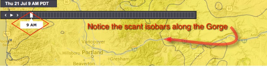
glassy calm conditions in the corridor.
Yet the forecasts suggest LATE strong winds especially way out East today. Why?
Looking at the first image above at 9AM note the compression of isobars (lines of equal pressure) stacked up along the coast. Higher pressure is to the west and lower pressure is to the east over the coast range. But without any venturi effect in that region the winds are very light.
Now looking at the same image note that there are almost no isobars over the Gorge. Hence the weak winds this morning.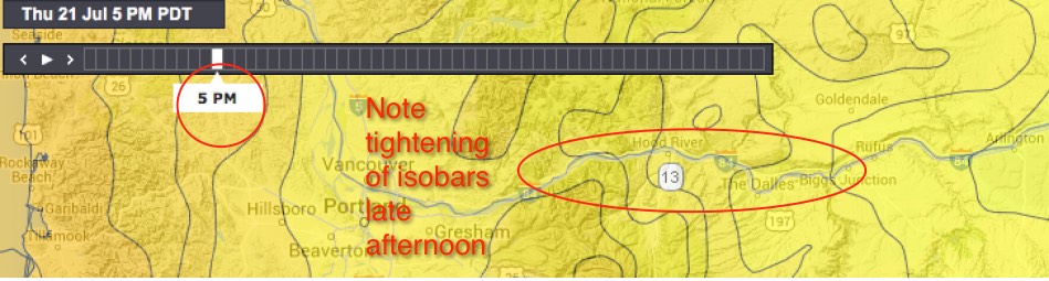
Now look at the second image for 5 PM today. Notice how tight the isobars are one the Gorge from about Stevenson to about The Wall. This means that there is a strong W. to E. pressure gradient in this region. But the pressure gradient tapers off as you get past The Dalles. But this concentration of isobars would by itself only produce low 20’s wind and the wind would taper off past Dougs. Yet the forecast is for strong LATE winds all the way to Rufus.
So there has to be some missing factor to make the winds reach towards the mid 20’s and to reach to The Wall.
So let’s first examine how the surface winds develop, in theory, during today. This first animation shows how the isobar dance we saw above plays out wind wise at the SURFACE.
Notice how weak the AM SURFACE winds are in the Gorge. Then note how the winds pick up in the late afternoon as the isobars tighten. Also note the focus of the winds in the Corridor to just past The Dalles. But still this is only low 20’s wind. So where does the stronger juice come from?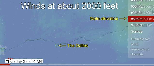
The next animation give the answer. Now we are looking at the modeled winds at the 950 hectopascal level at about 2000 feet of elevation. Notice not much action at that level until about 5 PM.
Then as a short wave upper trough passes over the Gorge momentum from 50 knot winds at that level stir up a blast of winds at 2000 feet which in turn transfers momentum to the surface winds. Typically this would mean gusty winds at the surface since the pressure gradient is mild.
Of course all of the above is derived from a couple of models and personally I am hoping the winds arrive much earlier!