 North Pacific High ridge, eddy & upper low may trigger a marine surge.
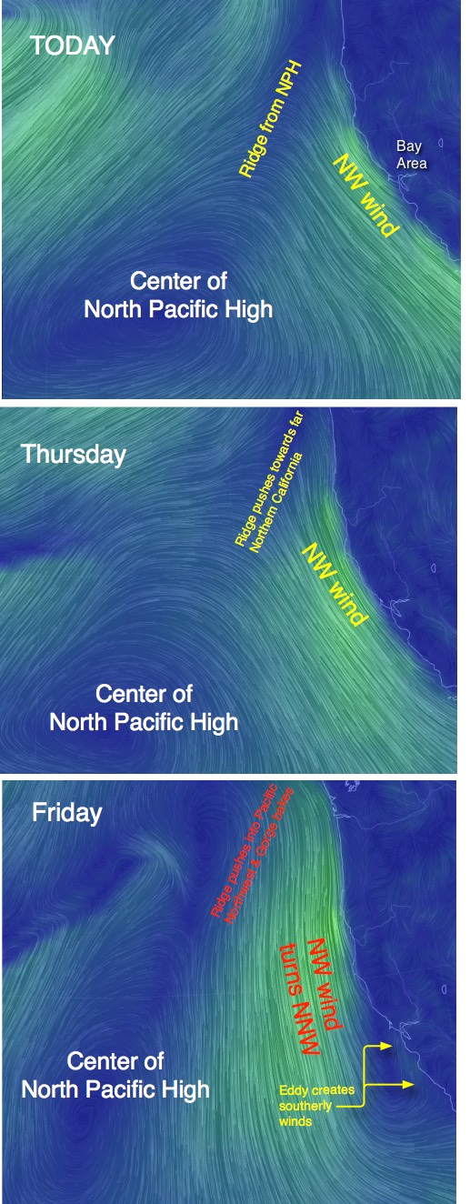
by Mike Godsey, mikeATiwindsurf.com
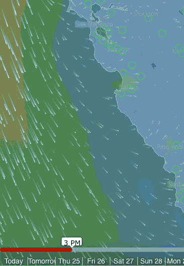
Last Sunday in the extended forecast I issued a Marine Surge Watch for this Friday. This is my jargon to give you a heads up that there is a chance of a surge of southerly wind and fog pouring through the Golden Gate on June 26. The top image shows how one model has the surface wind from Tuesday though Friday changing from NW to South. Check the time line at the bottom and you can see the southerly marine surge wind developing. I should be able to fine tune the ETA of the marine surge about 12 hours in advance. Right now it looks like Friday PM.
Typically marine surges happen at the end of a heat wave when Central Valley thermal low begins to pull back from the Bay towards its home in the Central Valley. As this happens a low pressure area often remains in the North Bay counties creating a South to North pressure gradient triggering southerly winds along the coast.
But the marine surge I expect sometime this Friday will be more complex than. This blog takes a brief look at some of variables behind this possible marine surge and why its arrival time will be hard to pin down.
Looking the first 3 images covering the surface winds today though Friday first find the North Pacific High. Notice how today today and Thursday the high is focusing NW winds along the Bay Area coast. But also notice that extension or ridge the NPH is pushing into far Northern California.
By Thursday the ridge has created North winds in Oregon to California’s Cape Mendocino. By Friday the NPH ridge is into the Pacific Northwest contributing to a massive heat wave there.
More importantly notice that with the ridge in that position the ocean winds near the Bay Area turn from NW to NNW or even N. Winds from that vector help create a huge counterclockwise eddy from Bodega almost to Southern California. So the Bay Area coast sees southerly winds and deeper fog.
However the typical low pressure in the North Bay is absent so the marine surge would be quite weak and would be unlikely to reach Sherman Island. I would hardly issue a Marine Surge Watch if that was all there was to this story.
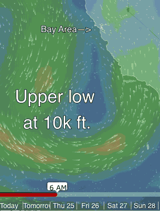
While all of this is happening at the surface at about 12,000 feet a sort of Cut-Off Low is forming towards Southern California. As you can see in the animation below this spiraling mass of air slides up the coast towards the Bay Area. By Friday I expect this mid level low pressure to create southerly flow on the ridge tops and jazz up the surface southerly winds from the ridge produced eddy.
The tricky part of the forecast is since this is a sort of Cut-Off Low and its trajectory could vary from the model output. And if it ends up in the wrong location the marine surge would fizzle. Hopefully the picture will clarify in the next 24 hours. Plus we have to worry about monsoonal moisture and clouds the Cut-Off Low may bring over the Bay Area which could weaken the pressure gradient.