
Why does a “good”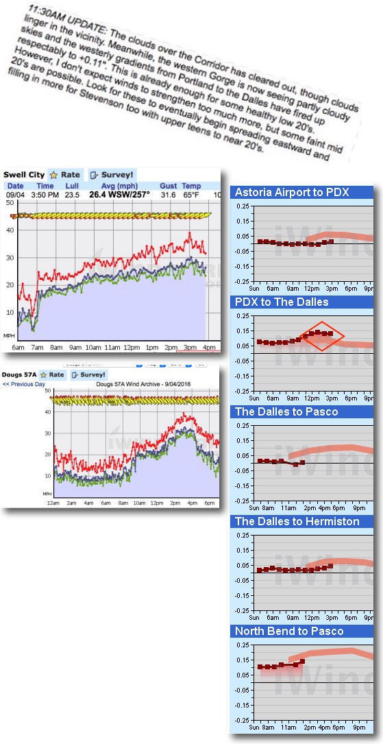 forecast go “bad”?
by Mike Godsey, mike@ AT iwindsurf.com
So take a look at Ben’s forecast update for the Gorge yesterday at 11:30 for the corridor winds. And looking at the Swell City wind graph you can see his forecast for low to faint mid 20’s was right on.
But it was clear by mid afternoon that his and all the other computer and human forecasts were also blown away but solid upper 20’s wind.
The question is… why do these blown forecasts happen. I mean all forecasting really just looking at the pressure gradients right? Wrong!
While the pressure gradient is an important variable the variables that shape the pressure gradients are incredible complex and sometime change dramatically in a few hours.
Moreover windsurfers and kiters often visualize winds at a 2D phenomenon. Since we only ply the surface with our boards we only focus on the variables like wind strength, gusts, lulls, direction, shifts etc. that directly impact our sail.
But often on the west coast where there is lot of topography the winds aloft can dramatically impact the surface wind in terms of wind velocity, gusts and wind shifts.
So in forecasting we do not simply look at the pressure gradient and the models surface winds but also at the winds aloft.
So yesterday at 7AM and 11:30AM the great majority of models showed a moderate pressure gradient from PDX to The Dalles. You can see this in the pressure graph above. In the graph the forecast pressure gradient is shown in the pink line while the red squares show the actual pressure gradient recorded from sensors.
Notice at 2PM yesterday the actual pressure gradient jumped significantly above the modeled pressure gradient. This is surprising since the pressure gradient largely reflects 2 variables: 1. the isobars from the North Pacific High off our coast and 2. The isobars from the heat induced low pressure in the Columbia Basin.
Since the Columbia Basin did not suddenly heat up in the afternoon and the NPH did not suddenly lurch towards the Gorge why did the pressure gradient and the Corridor winds ramp above the forecast levels?
The answer has to do with the winds aloft. Look at this animation of the modeled winds at 4PM yesterday.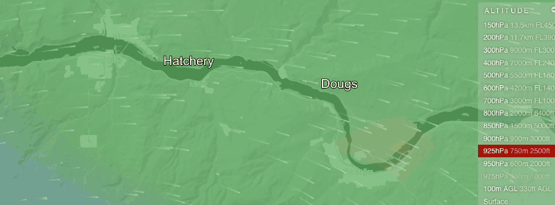
The first part of the animation shows the winds at about 2000-2500 feet as depicted GFS model. Note that it only has mild winds forecast just aloft in the Swell City to Dougs zone.
The second part of the animation shows the same winds as depicted by the famed european ECMWF that runs on the worlds fastest supercomputers devoted to modeling. Note the ECMWF only depicts mild winds aloft.
(It is not in my animation but the UofW MM5 also missed this blast aloft)
The third part of the animation shows the same winds as depicted by the NAM 5 model. Note the ECMWF only depicts strong WNW winds just aloft roaring over the Gorge in the afternoon. As this WNW wind hits the ridges up wind of the Hatch and Swell zone it becomes turbulent and transfers momentum to the surface winds as well as a direction shift.
This strong of wind also “moves” the isobars further east so the PDX-The Dalles pressure gradient jumps up and the winds at Dougs goes over forecast levels.
So why didn’t Ben notice this blast forecast by the NAM5? Probably because the NAM5 output only became available after the 11:30AM forecast had been issued.
Fortunately this is the type of blown forecast few complain about since it was a good day becoming a great day. It is on days we forecast weak winds and an epic day occurs that people get pissed.