The prevailing ocean winds in the San Francisco Bay Area from spring to fall are usually NW. 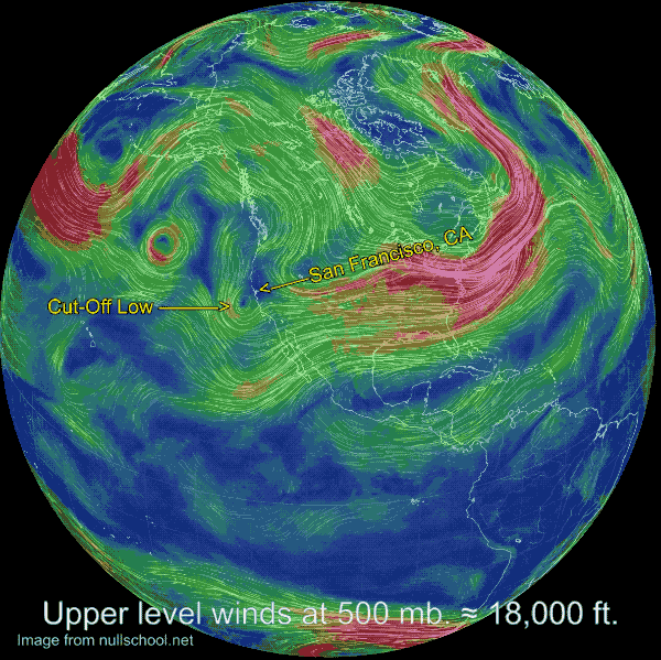
True the Bay Area gets southerly storm winds at times but that is usually during the winter and early spring.
And there are also WSW summer winds. But those winds are usually caused by northerly winds curving inside the Bay due to a pressure gradient towards Sacramento and the northern Central Valley.
But today, April 17, 2020, it looks like we see strong SW winds along the coast and inside the Bay triggered by a Cut-Off Low at ≈ 10,000 to 18,000 ft. aloft.
It always helps to look at the big picture so let’s start really BIG. This first image shows the globe and the modeled wind patterns today at about ≈ 18,000 ft.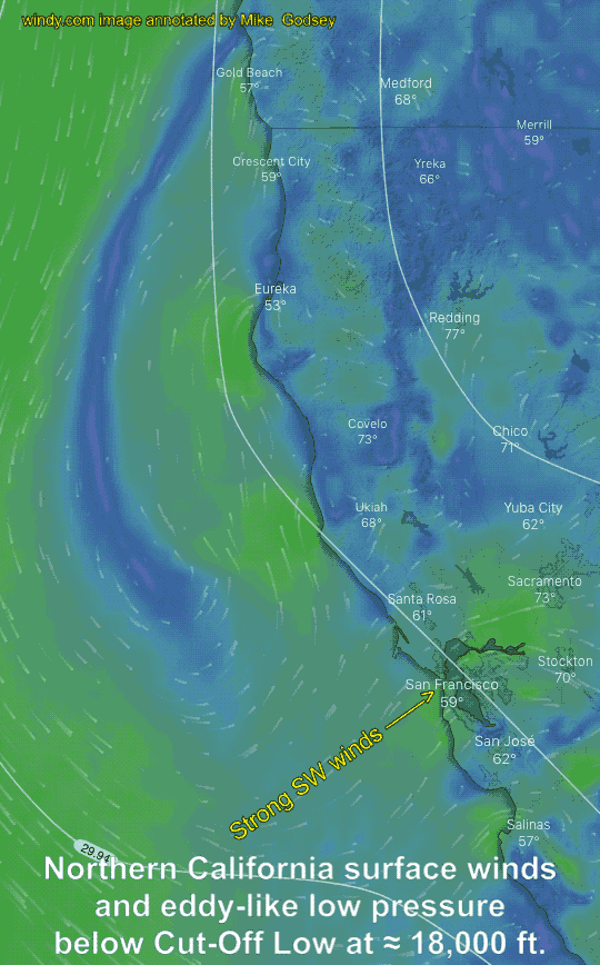
Notice the small counter-clockwise spinning mass of wind just SW of San Francisco.
Notice how this wind circulation is largely cut off from the overall flow of upper-level wind circulating from W. to E. around the world.
Once such an airmass is cut off from the overall circulation it tends to linger in place for several days until it is again caught up in the upper-level wind pattern. Hence the term Cut-Off Low for this type of airmass.
Often a Cut-Off Low will induce a counter-clockwise spinning surface low at the surface.
You can see this happening in the second image. Due to the presence of Northern California and the coast range, the low pressure looks more like an elongated eddy running parallel to the coast.
Notice how the position of this “eddy” today is throwing SW wind at the greater San Francisco Bay Area.
Since the Bay Area has a steep coast range running along the coast this SW wind has to find a pathway to the low pressure in the Central Valley and Great Basin.
And that pathway is provided by low-level gaps or valleys in the mountains.
These gaps act to focus and accelerate the wind in areas downwind of the gaps.
The third image shows the modeled wind distribution that all these factors produce.
So it will be interesting to see if later today all of this actually plays out as I am forecasting.
There is a reason for the old aphorism “A Cut-Off Low is a weatherman’s woe” From reading the above can you guess why a forecast made during a Cut-Off Low event may turn out bad?