What is a Jet Stream?
In its simplest form, a jet stream is any prominent upper-level (above 500 mb) air current. For each hemisphere, there are 2 main jet streams—the polar jet stream, and the subtropical jet stream. A jet stream does not have to be (and rarely ever is) complete around the globe at an instant in time; it often is stronger in some areas, patchy or weak in others, or simply not present at all. A jet stream is distinguished by meteorologists in regions where the upper level winds are at least 50 kts(1).
Jet streams are driven by the uneven heating of the Earth’s surface creating an equator-pole temperature gradient. Instead of the winds simply blowing equator to pole, though, because the Earth is rotating, a force known as the Coriolis force deflects the winds (to the right in the northern hemisphere and left in the southern hemisphere), ultimately causing westerly zonal flow.
The jet streams are located around 50-60°N/S (polar) and 30°N/S (subtropical) because this is where the temperature gradients are the strongest in each hemisphere. The polar jet varies more in its N/S location because the angle of the sun hitting the Earth varies widely throughout the year which means the region of strongest temperature gradient also varies. In the tropics, however, the sun’s angle fluctuates on much smaller magnitudes so the subtropical jet stream has more consistent temperature gradient locations year-round (2).

Influence on Upper Air Patterns
The jet streams play an important role in shaping both upper and lower air circulation; ultimately, it is the highway that High and Low pressure systems use to get across our country. To understand how entire weather systems move, you must know the position and trend of the nearest jet stream. While the jet stream has an infinite amount of possible positions, there are a few common patterns that often take hold and significantly propel or stall developed systems.
Open Waves (Meridional pattern)(3a,b) – resemble a squiggle, or wave, of isobars. Open waves often have no more than 2 of one system—either 2 Lows and 1 High, or 2 Highs and 1 Low—that can fit over the contiguous United States (this is due to Rossby wave limitation which could take up an entire blog post of its own to explain).

Zonal Flow (4)– another common pattern, where the jet stream is stretched out almost like a line of strict westerly flow. Without wasting time bending north or south, systems inside zonal flow move swiftly across the US, though poleward of the jet stream systems tend to sit in limbo waiting for a meridional disturbance to attach to.

Cut-Off Low (5) – when a meridional perturbation gets so deep that it separates from the jet stream and forms a closed circulation aloft. The result is a zonal jet stream flowing past the independent Low pressure system without pulling it eastward with any noticeable strength. Cut-off lows move very slowly and can sit over a region for extended periods of time before another meridional perturbation deep enough comes along to scoop it up.

Influence on Surface Winds
The primary way jet streams influence surface winds is by transporting High and Low pressure systems across the country. Due to the Laws of Conservation, changes in upper level (UL) flow of jet streams are balanced by ageostrophic winds which induce vertical circulation. What that means, is that an UL system impacts a lower level (LL) system through vertical winds. This makes sense because jet stream winds moving in the 250 mb X-Y plane would not be able to affect LL winds in the 925 mb X-Y plane unless there was a vertical (X-Z or Y-Z plane) component; this component is achieved through ageostrophic convergence and divergence aloft.
Ageostrophic convergence aloft occurs on the western side of troughs (eastern side of ridges), and ageostrophic divergence aloft occurs on the eastern side of troughs (western side of ridges). See a sketch of this below:

The converging air aloft is capped by the tropopause so the winds flow vertically downward towards the surface where they must then diverge outwards; this surface divergence lends itself to a High pressure center.
Alternatively, the diverging air aloft sucks up air from the surface then sends it outwards along the tropopause; this upward pull at the surface creates LL convergence which lends itself to a Low pressure center. The final result are systems that “tilt” west with height from the LL to UL. See sketch below:

Once we can establish the position of LL High/Low pressure systems, then it is easy to determine the surface winds from a basic knowledge of how winds move in cyclonic flow (Low pressure) versus anticyclonic flow (High pressure).
We can sometimes use an element of a jet stream, known as a jet streak, to further predict surface conditions. Jet streaks are portions within a jet stream that have more intense speeds. The position of a jet streak along an upper level trough or ridge will impact the system’s ability to grow or decay. In the 250 mb upper air chart below, the jet stream is the colored green/yellow/red/purple area, and the 2 jet streaks are particularly the dark red and purple colored portions.
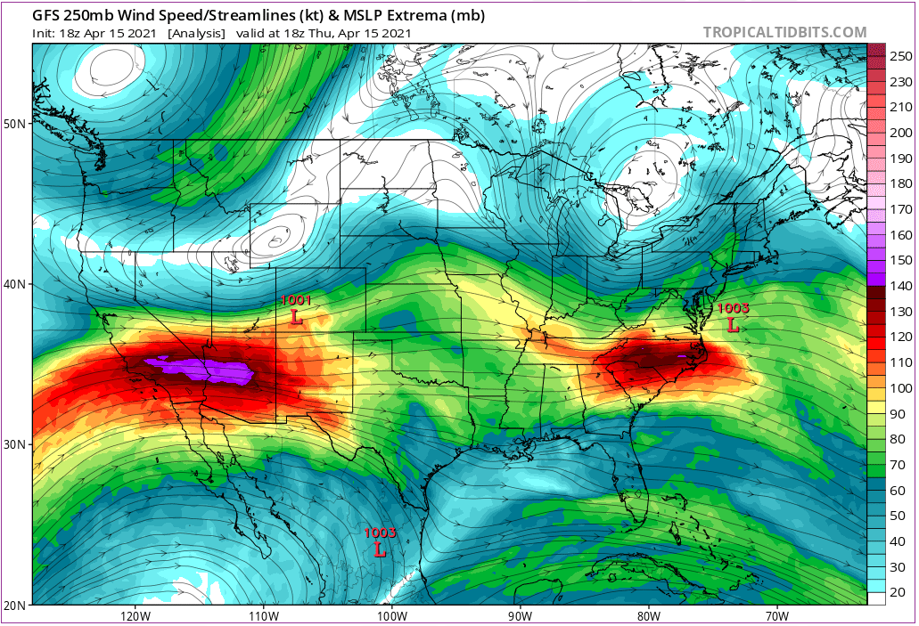
Both jet streaks are slightly southwest of LL Low pressure centers. We expect the jet streaks to enhance the strength of the LL Lows because the stronger the zonal UL flow is, then the stronger the vertical flow interacting with the LL zonal flow needs to be. Additionally, this jet stream (and its streaks) is displaying a zonal flow pattern (see previous section for this description); with the streaks’ alignments slightly southwest of the Lows’ centers, we expect the streaks to “spin up” their adjacent Lows by adding westward flow to the SW quadrant of the system.
Key Takeaways
- Jet streams are regions of strong (50+ kts) westerly winds in the upper atmosphere driven by meridional temperature gradients.
- The 2 most prominent and consistently occurring jet streams are found at 50-60°N/S (Polar jet stream), and ~30°N/S (Subtropical jet stream).
- Jet streams have an infinite amount of flow patterns/locations but a few of the common patterns that occur are:
- open waves,
- zonal flow, and
- cut off lows.
- Jet streams interact with the surface winds through ageostrophic winds and vertical circulation.
- Converging UL ageostrophic winds aloft between an UL High and Low tend to assist in developing a LL High; Diverging UL ageostrophic winds aloft between an UL Low and High tend to assist in developing a LL Low.
- Jet streaks are areas of stronger winds within a jet stream. They can assist in development of LL systems if positioned aloft correctly.
Still curious? Check these out!
- Current global jet stream positions: https://www.netweather.tv/charts-and-data/global-jetstream#2021/04/20/0600Z/jetstream/surface/level/overlay=jetstream/orthographic=-6.72,57.59,712
- NWS Upper Air Charts: https://www.weather.gov/jetstream/constant_intro
- NWS Global Weather: https://www.weather.gov/jetstream/global_intro
- Jet Stream and Jet Streaks: https://www.weather.gov/source/zhu/ZHU_Training_Page/winds/JetStream_Stuff/300_200_chart.htm
Sources
(1) “Jet Stream.” Glossary of Meteorology, American Meteorological Society via: https://glossary.ametsoc.org/wiki/Jet_stream
(2) Global Weather: The Jet Stream. JetStream, National Weather Service via: https://www.weather.gov/jetstream/jet
(3a) Upper Air Charts: Basic Wave Patterns. JetStream, National Weather Service via: https://www.weather.gov/jetstream/basic
(3b) Ackerman, S.A. & Knox, J.A. (2015). Meteorology: Understanding the atmosphere 4th ed. Jones & Bartlett Learning.
(4) Upper Air Charts: Basic Wave Patterns. JetStream, National Weather Service via: https://www.weather.gov/jetstream/basic
(5) Upper Air Charts: Basic Wave Patterns. JetStream, National Weather Service via: https://www.weather.gov/jetstream/basic