Early arrival of summer type dense marine layer.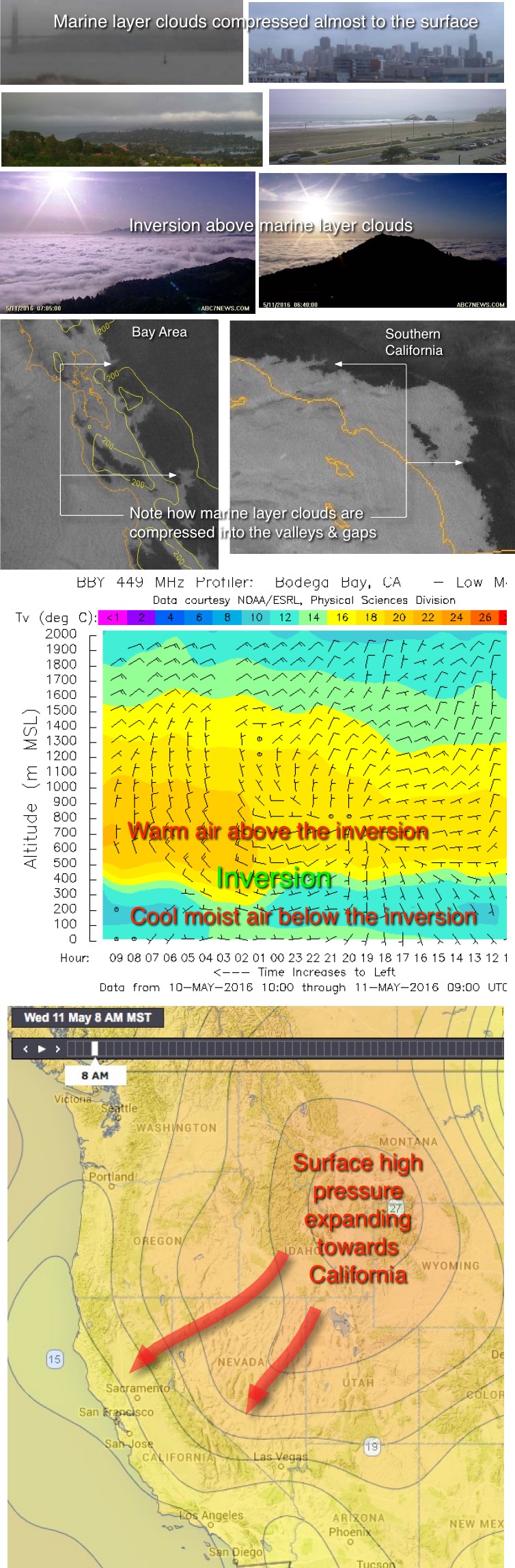
by Mike Godsey
Dawn today in coastal Southern California or S. F. Bay Area found dense fog almost to the surface. These type of marine layer clouds are usually typical of June Gloom and their early arrival is triggered in part by the unusually warm pacific waters this year.
Looking at the first 4 photos it looks like a miserable day for a hike up the hills. Dreary fog at the Golden Gate, Ocean Beach and over the bay waters. But hikers in the know have learned that when the marine layer is dense like this the hilltops are basking is warm glorious sunshine as you can see in the next 2 photos from early this morning.
All of this may seem like hiking trivia but it actually reveals a lot about Bay Area and Southern California winds. Looking at those same 2 photos notice how the top of the marine layer clouds is relatively flattened. That zone is known as the inversion point. Sometimes the inversion point is so defined that you as walk downslope it almost looks hard enough that you could walk across the top of the marine layer. What makes the inversion and why is it important for wind? Hang on…
Now let’s take at the satellite imagery from the same time this morning. Looking at both Southern California and the Bay Area notice how the marine layer clouds have oozed well inland overnight. But also notice how you can see how the fog has flowed inland following the contours of the topography. At leading edge of the marine layer you can see every valley and gap in the coast range. It almost looks like a giant hand squashed the marine layer clouds down into the valleys.
Next look at the imagery from the 449 MHz profiler at Bodega Bay in the North Bay. This vertical radio signal detects both wind direction aloft and the air temperature at different levels. Notice the very cool air that extends from the surface to about 300 meters or about 1000′. Then note the abrupt transition to much warmer air. The point where these two very different air masses meet is the inversion. The cool air near the surface is relatively heavy dense air and if wind blows in this layer the wind tends to be very steady since as it encounters hills or trees etc. it lifts and then quickly reattaches to the surface. So if you go hiking on a day like this you will find warm still air above the inversion but cool windy air below.
So why are the marine layer clouds so compacted towards the surface today? The answer starts far to the east. Looking at the last image note the high pressure in the Great Basin area. This high pressure area is moving closer to California. Within this high pressure zone the air is descending so it compresses as it encounters the surface. If you have ever filled a SCUBA tank, or vaguely remember the gas laws, you know that when you compress air it heats. So today as the warm air descends over California it is compressing the marine layer clouds and creating a moderate inversion above the marine layer.
So all we need is a strong pressure gradient towards the valleys and we will see steady moderate wind in both the Bay Area and Southern California. And looking at Kerry’s 7 AM forecast today it looks like both Southern California and Bay Area sites favored by SW flow will reach the upper teens!