Have you ever driven near one of the Great Lakes on a sunny day but all of a sudden, you are immersed in white-out conditions, heavy snow is falling, and the car that was once visible in front of you has become almost invisible? You may have driven into a snow squall where lake effect snow is prominent near large bodies of water during the late fall to early spring months. Lake effect snow is known to contribute to 10-50% of the winter’s precipitation over the Great Lakes (Shi and Xue, 2019) (Figure 1).

Figure 1. Observed snowfall analysis December 8-10, 2016, by NOAA Environmental Visualization Laboratory, 2016,
(https://www.climate.gov/news-features/event-tracker/lake-effect-snow-buries-parts-great-lakes-december-2016).
But how does lake-effect snow form? Lake effect snow forms when cold, dry arctic air moves over an unfrozen warm body of water. The warm parcel of moisture rises into the cold air above, becoming positively buoyant (unstable), allowing precipitable clouds to quickly form (Figure 2).
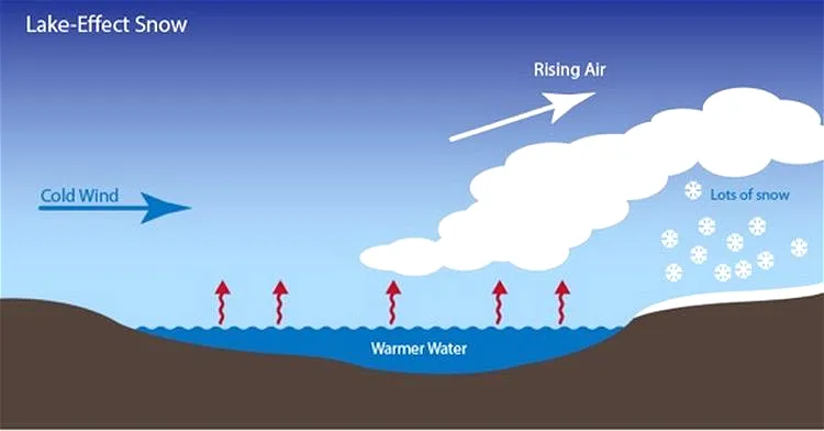
Figure 2. Lake-Effect Snow, by M. Breederland, 2016,(https://www.canr.msu.edu/news/warm_great_lakes_bring_significant_lake_effect_snow_msg16_breederland16).
However, specific criteria are needed for lake effect snow to develop. A temperature difference of at least 13 degrees Celsius (or 23 degrees Fahrenheit) between the 850 mb atmosphere and the lake is required for the lake effect to develop. The greater the temperature difference, the bigger the lake effect event!
Fetch also plays a vital role with a distance of at least 75 km (50 miles) to allow for enough moisture to become unstable in the atmosphere. Fetch is when the direction of the upper wind moves over a great distance of the lake (Figure 3). This allows more warm moisture to become unstable and thus creates a more significant snowfall event.
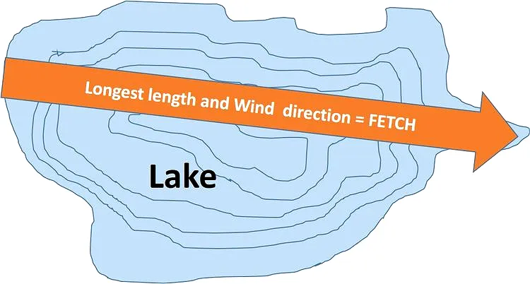
Figure 3. Diagram of a lake showing wind direction of fetch, by B. Clawson, 2017,(https://www.canr.msu.edu/news/understanding_lake_fetch).
Such events can create large snow squall bands that stretch several kilometers and can be visible through radar and satellite imagery (Figure 4). Snow bands require weak vertical wind shear or winds that flow in the same direction with increasing height.
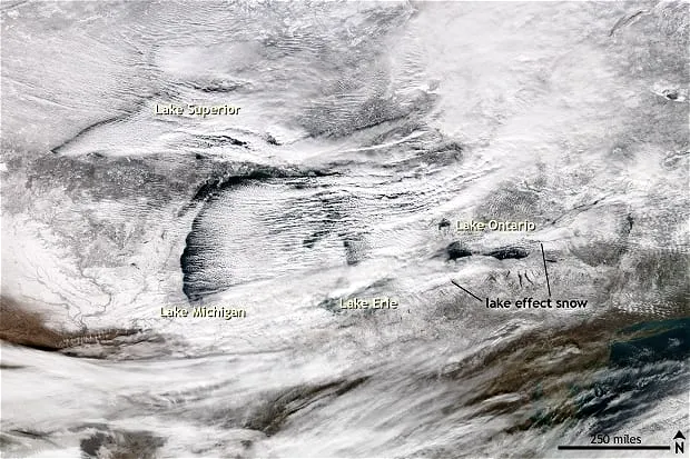 Figure 4. VIIRS satellite image on December 14, 2016, by NOAA Environmental Visualization Laboratory, 2016, (https://www.climate.gov/news-features/event-tracker/lake-effect-snow-buries-parts-great-lakes-december-2016).
- Written by Ida Hung
- Edited by Spencer McCormick