Watch this Cut-Off Low trigger an atypical mild marine surge.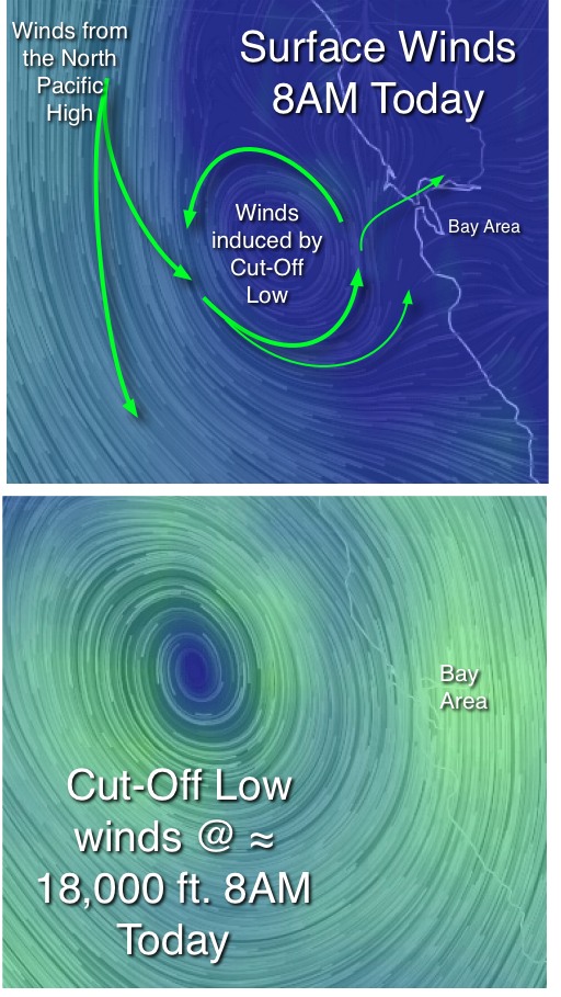
by Mike Godsey, mike@iwindsurf.com
As expected this Cut-Off Low triggered marine surge has been mild and very atypical. But overall the marine surge has been even weaker than expected. Anytime a Cut-Off Low is in the wind equation things get unpredictable.
Today, as Claire forecast, the SW marine surge flow is very modest. Let’s take a look at some imagery to see why this is happening.
 In the first image we are seeing the GFS model output. Notice that there are very strong NNW winds from the North Pacific High far to the west. But the Cut-Off Low at about 18,000 ft. has induced a counter-clockwise low pressure at surface to our west. This is where our SW flow is coming from. But the low pressure is so far to the west that only a hint of those winds are reaching inside the Bay Area.
The second image shows the actual Cut-Off Low at about 18,000 ft. Note how powerful the winds are way above the Bay Area. You might expect that all that wind would stir up our surface wind. But today there is a strong inversion at about 2000 ft. so the cool dense surface air is barely moved by all that wind aloft.
The third image is an animation of the last 24 hours of the satellite imagery of the Bay Area. The long pause you see in the video is the END of the video. At the start of the video you see the Cut-Off Low stirring the surface clouds in a counter-clockwise fashion. Then the image goes gray as the sun went down last night. Then notice how the SW winds induced by the Cut-Off Low shove the marine layer clouds into the Bay Area. Then the image goes bright at dawn today and you can see the impact of the Cut-Off Low more clearly.
There is a corny old saying in meteorology. “Cut-Off Lows are a weatherman’s woe” And if the Cut-Off Low you see in this imagery were to suddenly shift eastward towards the Bay Area we could abruptly see Rio Daze this afternoon.