No matter our coastal sport of choice, whether kiteboarding, windsurfing, fishing, sailing, surfing the old-fashioned way, etc., the nature and quality of our day depends heavily on wind direction and speed and wave height, direction, and period.
This blog addresses an effort by the NWS to improve the quality and usefulness of their Coastal Waters forecasts, specifically as they address wave detail. This is an important potential upgrade for all of us and the NWS has come up with an initial proposed format. They are asking for our input.
THE CURRENT TEXT FORMAT
As a reminder, here is the breakdown of a typical Coastal Waters Forecast bulletin.
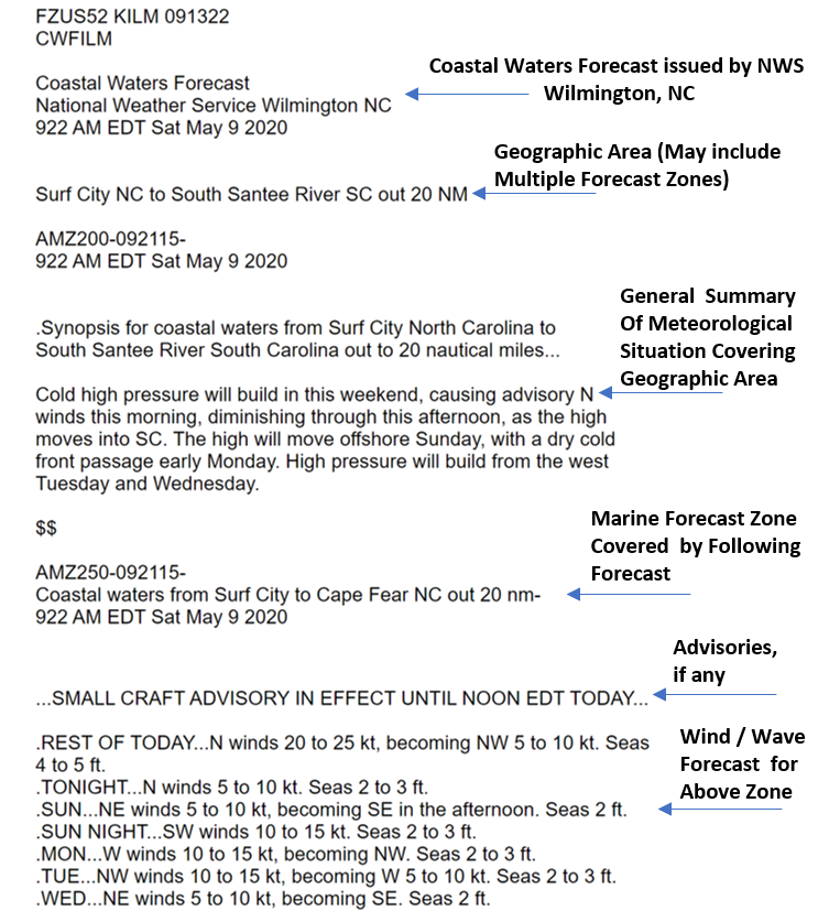
Figure 1 Current Coastal Waters Text Format
While it is quite simple and straightforward, the seas forecast portion lacks critical information. As important as sea height might be, it is not the only variable contributing to comfort, safety, and the quality of our experience. Also important are:
- Direction of the waves (from which they are coming)
- Existence of multiple wave trains (perhaps wind driven waves from one direction AND swell from another)
- Period of the waves for all wave trains (the time (in seconds) required for a complete wave cycle. For example, the time between successive wave crests (or troughs) passing a fixed point).
I can speak from experience that my boat can be perfectly stable in a 6 ft sea while rolling uncomfortably in 3 ft seas of a certain period from an unfriendly direction.
THE PROPOSED TEXT FORMAT WITH WAVE DETAIL
Aware of this shortcoming, our friends at the NWS WFO Wilmington have taken the initiative to improve on the Coastal Waters Forecasts and they are seeking our input on the addition of “Wave detail” to the text forecasts. Here is an example of their current proposed format.
![]()
Figure 2 Proposed Coastal Waters Text Format with Wave Detail
Let’s look at the “Rest of Today” forecast and particularly the additional “Wave Detail” in Figure 2. In the existing forecast, all you would see is “Seas 4 to 5 ft”. The additional Wave Detail tells you that those seas are made up of 2 wave trains: a 4 ft wave coming from the north with a period of 5 seconds and a secondary 2 ft swell coming from the south with a 7 second period. With this information the boater, whether fishing, sailing or just messing about, can more accurately assess the impact of the seas on his/her day at sea. Of course, it is not just about offshore boats; surfers know that direction and period of swell is a critical variable in assessing the quality of an upcoming surfing day and we all care about conditions in the surf zone.
WHERE DO WE GO FROM HERE – HOW WE CAN HELP
As mentioned earlier, the NWS folks at WFO Wilmington are seeking our input on this proposed enhancement to the Coastal Weather Forecast.
To help us compare a forecast in the present format against the same forecast in the proposed format, the WFO has created: https://www.weather.gov/ilm/proposedcwf. Here, you will see the latest forecast as show in Figure 1 but, if you move your cursor over the forecast portion of the text, you will see a box appear with the proposed format (Figure 3).
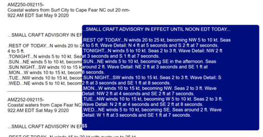
Figure 3 Easy Comparison of Current Versus Proposed Format
You will also find an email link to provide your feedback: ILMwaves@noaa.gov using the subject “Wave Detail Feedback”.
Finally, to hear about the effort directly from the WFO, check out: https://www.weather.gov/ilm/wavedetail for a short video about the program.
Feedback from the Weatherflow community is important and I encourage you to help the NWS in their product enhancement efforts on our behalf.