
Typically this would mean massive SW winds all day but gradients are weak
One of the great challenges in Bay Area wind forecasting is predicting the genesis and death time of the Golden Gate eddy. In the old days of Bay Area wind forecasting 20 years ago we were oblivious of the existence of the eddy much less what caused it and how long it would thrive. So back then we would sometimes be forecasting weak North Bay and East Bay winds and upper teens to low 20’s wind on the Peninsula only to awake and find Sherman Island showing 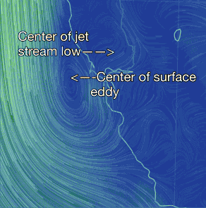 with Pt. Isabel and Larkspur blowing in the afternoon. Now we are usually able to forecast the Golden Gate eddy and SW winds a day in advance. But it is still tricky forecasting how big the eddy will be and even more tricky to forecast when it will die. And this is critical information for Peninsula and Waddell folks since if the eddy goes most of the afternoon those sites will have weak or poor quality wind.
Today I am pretty confident that the eddy will endure until at least mid afternoon. Why? Because this eddy has serious support aloft. Check out this animation. We are looking at the counter-clockwise spinning winds near the Bay Area. In the first image you are looking at the surface eddy with the caption pointing out its center. The in each successive frame we jump elevation until you are seeing the red and yellow massive winds of a jet stream low pressure up at 25,000 to 40,000 feet. All of this counter-clockwise spinning aloft will tend to keep the surface eddy and southerly low intact. Then mid afternoon this upper level low pressure moves to the east and the surface eddy should fade.