 Northern California deprived of NW wind while Gorge lacks high pressure for the duration.
by Mike Godsey, mike@iwindsurf.com
Funny how we take things for granted. Each year around late September the NW wind gradually becomes weaker and less reliable and by late Oct. it is often only a memory. The Bay Area has the most reliable winds on the west coast for a simple reason. We have major 2 wind engines. The pressure gradient to the Central Valley that creates great thermal winds. And the North Pacific High’s surface NW winds. And often the 2 work together. With pressure gradient sucking in the North Pacific High’s surface NW winds where they combine with the thermal winds going to the Central Valley.
Now the gradual fading of the thermal winds in the Bay Area and the Gorge in the fall is easily understood. The sun rises later, sets earlier and its angle is lower in the sky. So there is lest heating in California’s Central Valley and the Columbia Basin. This means a weaker pressure gradient so weaker wind.
But why does the North Pacific High weaken and why do the NW winds become less common as fall then winter approach? Basically it’s the same reason the angle of the sun. The North Pacific High is created by a band of huge thunderstorms that span the pacific in the zone where the trade winds from the North Pacific High and the South Pacific High converge in the tropics. In this, area known as the InterTropical Convergence Zone or ITCZ, constant huge thunderstorms pump enormous amounts of air into the atmosphere. Part of this air descends far to the north to the surface and creates a huge dome of high pressure air known as the North Pacific High. In the spring the ITCZ marches northward as the sun appears higher in the sky each passing day. And the average location of the North Pacific High moves northward with it. But in the fall, as the sun becomes lower in the sky, the reverse happens and the North Pacific High moves southward.
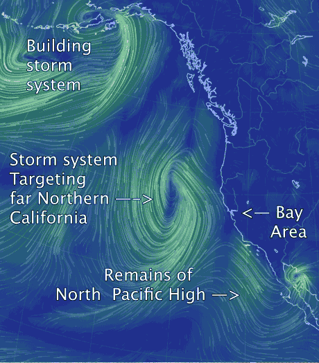
The reality is more complex since even in the summer passing upper troughs push the North Pacific High southward for a few day so the Gorge winds weaken and the Bay Area loses its NW wind. But as fall progresses and the angle of the sun decreases those upper troughs drop further south and the North Pacific High retreats further from the west coast. And finally we reach a point where, like today, winter type storms near the west coast.
The North Pacific High looks almost totally wiped out in the video but never fear. It will rebound since the systems you see creating SW storm winds pass. But the North Pacific Highs short vacation this week to the south is a harbinger of its coming departure to it’s southerly winter home.