So weaker Gorge, Bay Area Peninsula & coast winds.
by Mike Godsey, mike@iwindsurf.com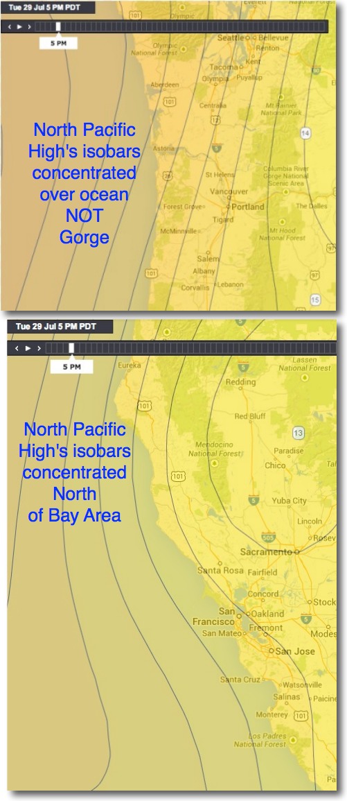
The Columbia River Gorge and the San Francisco Bay Area Peninsula and coast had a long spell of unusually weak winds the last 2 weak. Sometimes this was due to monsoonal clouds aloft and even sprinkles. Sometimes is was related to a weak pressure gradient in the area. And unbelievably sometimes the Hatch blew even through the middle of a heat wave.
Let’s explore some of the major causes of this weird wind drought. In a recent blog on monsoonal clouds I explained how these clouds weaken the wind. But normally monsoonal clouds are a 1-2 day event. Yet here we are a week later and there is still mention of these clouds in the forecasts! Meteorologist call this a stagnate pattern. But before we explore that stagnation let’s look at another issue
The North Pacific High, that giant clockwise spinning feature located between the west coast and Hawaii has been greatly distorted in recent weeks and has kept that distortion much of that time. This distortion has created an unfavorable focus of it’s isobars for most of the Gorge and pars of the Bay Area.
Let’s look distribution of the NPH’s isobars yesterday July 29..
The Gorge: Looking at the top image find Portland and The Dalles area which roughly bracket the western Gorge. Note how the isobars of the North Pacific High are closest together out just west of the coast. In a normal summer pattern those isobars would be concentrated over the Gorge making for a strong pressure gradient and powerful wind in the Swell City to Doug’s zone. So while the Columbia Basin has been hot and has low pressure the pressure gradient is not concentrated over the Gorge. Hence modest winds.
The Bay Area: Now look at the 2nd image. Find San Francisco and note the Peninsula to the south and just north of Santa Cruz are the fabled wave sailing sites like Waddell. Note how the North Pacific High isobars are concentrated off of Cape Mendocino well north of the Bay Area. This positioning means the ocean wind west of the Bay Area is NNW rather than the normal NW.
NNW rather than NW sounds like a subtle difference but give the orientation of the California coast it means only a bit of wind reaches the Bay Area coast. Moreover NNW winds favor the creation of a small eddy west of the Golden Gate that further weakens the coast and Waddell winds.
The next part of the weak wind mystery is the monsoonal clouds which never seem to depart. With these clouds over the Central Valley and Columbia River Basin the pressure gradient has a hard time reaching its full sometime strength. So why are these clouds hanging around.
Let’s drop to the video at the bottom. This video starts with surface winds in GREEN. Then the video jumps to 18,000 feet 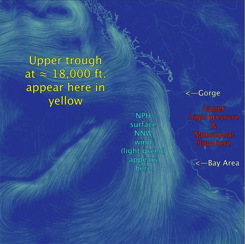 and shows the upper level winds in YELLOW. Looking at the green arrows locate the North Pacific High and the northerly winds along the west coast. Normally the NPH has an oval shape and extends from the west coast to past Hawaii. But in this case notice how it seems crushed against the coast. Now look at the much stronger upper level winds in YELLOW. The loop you see in these winds is called an upper trough. Normally an upper trough tries to push the NPH eastward then at the upper trough passes to the east the North Pacific High pops back into position out in the Pacific. But this has not happened the last 2 weeks. Why? Look at area east of the west coast and at the monsoonal clouds video and note the upper high pressure. This feature has been anchored over the desert west for almost 2 weeks. This in turn has locked the upper trough in position. So the North Pacific High has stayed in the crushed position causing the isobar distribution discussed above. Meanwhile the upper high pressure has continued to pump high clouds and humidity into much of the west coast. This stagnant pattern is beginning to break down so both the Gorge and the Peninsula are seeing improved winds.