What is a Waterspout?
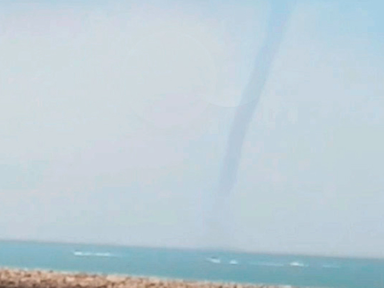
According to the American Meteorological Society’s Glossary of Meteorology, a waterspout is “any tornado over a body of water” (1). Other sources like NOAA define a waterspout as “a whirling column of air and water mist” (2). In another artistic almost phantasmal description, a waterspout is a “ghostly spiral of wind skimming the sea surface” (3). Combining all these takes, we get a pretty full picture: a waterspout is a tornado of air and water mist skimming over water.
Types of Waterspouts
The 2 primary classes of waterspouts are Fair Weather, and Tornadic. The distinction is based on factors like formation conditions, size and strength, and lifetime length.
Fair Weather Waterspouts
Just as the name would suggest, fair weather waterspouts form in calm pleasant conditions. In terms of atmospheric conditions, often the sky is covered with prominent cumulus clouds, the air is rather humid, and winds are light (6). Below the air, however, we are required to have a large open span of water with surface temperatures warmer than the air; this is critical because the boundary layer between the water and the atmosphere needs to be unstable for a disturbance like a waterspout to form. A disturbance is created when the water heats up the air just above it so that it is warmer than the surrounding atmosphere and must mix upwards to re-establish stability (4). The waterspout forms at the surface of the water and then grows upwards (3).
Lifespans of fair weather waterspouts are fairly short, ~5-10 minutes. They are narrower and weaker (in terms of damage) than tornadic waterspouts, and usually they don’t move very far after formation (1,5,6). It is almost impossible to spot fair weather waterspouts on radar or satellite, and most watches and warnings for them come in advance as a potential threat, or from local sightings and reports of activity, respectively.
Tornadic Waterspouts
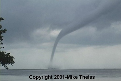
Again, as the name suggests, tornadic waterspouts are extremely similar to tornadoes we see over land (and sometimes tornadic waterspouts start out as land tornadoes and then just moved over water!). Tornadic waterspouts form in highly convective atmospheric conditions, like supercell thunderstorms, where the atmosphere is ripe with instability and energy. Opposite of fair weather waterspouts, tornadic waterspouts originate in the cumulonimbus cloud base and grow downwards to the water. They are much stronger than fair weather waterspouts and also larger, with diameters surpassing 100 meters (1). Tornadic waterspouts are sometimes able to be detected by radar, but not always.
Waterspout Formation
Fair weather formation
There are a few different ways to describe the formation of a fair weather waterspout, but in each description, there are 4 main steps:
- Dark spot
- as the winds initiate vorticity to try and balance the unstable conditions at the surface, a ring-shape along the water becomes visible resembling a dark spot.
- Spiral pattern
- with increasing vorticity, distinguishable streaks of air being sucked into the center of the vortex appear on the water’s surface.
- Spray-ring
- the vortex initiates lifting and water gets pulled upwards and thrown outwards with it, developing the spray ring, sometimes also called a cascade.
- Mature spray vortex
- the vortex continues its upward extension bringing water and moist air along with it growing into a funnel that can reach as far up as into the cloud base. As the funnel grows with height, it takes on an almost rope-like shape of tight vorticity; the surface (and sometimes up to hundreds of feet above the surface), however, will still have a much wider and less dense spray ring due to the intense sucking pressure along the water’s surface.
Tornadic formation
Tornadic waterspouts form either over land and then move onto water, or over water and then stay on the water (and sometimes then move onto land!). In either case, the initial formation process is the same. The steps of formation, as explained by NOAA (7) are as follows:
- Initiation of a supercell storm
- An intense thunderstorm that “contain[s] updrafts that rotate about a vertical axis,” also known as a supercell, must develop (7b). Strong shear must be present throughout the storm system.
- Horizontal shear aloft
- Horizontal winds moving in opposite directions in the base of the supercell clouds create a horizontal vortex of spinning air.
- Updrafts
- Continuous prominent vertical updrafts caused by the supercell sucking in air from the surface forces the horizontally oriented vortex into a more vertically oriented position.
- Stretching
- The almost vertically oriented vortex then tightens and stretches out from the base of the clouds towards the ground as its vorticity increases. This is called a funnel cloud; when the funnel cloud grows long enough to touch the ground, it becomes a tornado.
Video Explanation
Now, if all of this text is getting just a tad boring for you, or if you’re craving another form of visual learning, then check out this video by The Weather Channel explaining how waterspouts form (accompanied by overly sensationalized music)!
Where Can I See a Waterspout?
At a first Google attempt, you are likely to discover that the Florida Keys are described as the “World’s Capital of Waterspouts” (8). With their tropical waters and annual warm temperatures, the Keys are a breeding ground for waterspouts. Additionally, since the Keys have ample convective activity particularly in the summer, they support their fair share of tornadic waterspouts. Southern Florida also can produce an environment conducive to waterspouts, and while not generating as many as the Keys, they still produce many noteworthy ones. Check out this time-lapse video of a tornadic waterspout near Aventura, FL from August 2020:
Don’t live in Florida but now itching to spot a waterspout yourself? Fear not! The Great Lakes are also known for their late summer and early fall waterspout season. You are less likely to see a tornadic waterspout over the Great Lakes, however, where their reputation comes from numerous fair-weather waterspouts. On August 5, 2020 there were more than 40 waterspouts reported over Lake Erie (9). In the last week of September 2020 into the first week of October 2020, there were 240 waterspouts reported throughout the Great Lakes—a new record for the number of waterspouts in the Great Lakes in a 1 week period (10).
Okay so you still live hours away from Florida and all of the Great Lakes, well that makes things harder, but not impossible to see a waterspout. In the United States, coastal regions along the Gulf of Mexico or Carolinas have the next best shot at seeing a waterspout in person. Waterspouts on the west coast and northeast coast do occur, but let’s just say that your chances of witnessing one of these on a week long summer vacation to the Cape are much much slimmer than a week-long summer vacation to Key West. BUT! Any readers from the west coast or northeast coast who have seen a waterspout (and maybe even have photographic evidence), definitely tell me about it in the comments! If you are itching for some abroad travel, Greece and eastern Australia are also prominent waterspout formation regions (11).
I’m on the water and I see a waterspout. What do I do?
As with any severe weather system, you should respect mother nature and take the necessary steps to keep yourself safe. As a disclaimer, I am not an NWS forecaster or severe weather safety specialist, and I urge you to consult national resources for the most up-to-date practices of waterspout safety. But, since you’re reading this now, I’ll share with you what the current recommendations are of the NWS to avoid being lifted off a boat named Kansas and being deposited in a wet City of Oz.
So, you are on the water and you hear over your radio/get a notification on your phone/spot waterspout activity; what do you do? If able to, you should turn that boat around or ride that kite to shore. Waterspouts are significantly weaker when they move from water to land (if they even get that far), so you are much safer on solid ground (5). Now maybe shore isn’t an option—you’re on an offshore sailing race or perhaps you’re windsurfing far out in the bay and the waterspout is forming just outside the harbor entrance—what now? According to the Miami Weather Forecasting office, you should “immediately head at a 90 degree angle from the apparent motion of the waterspout” (6). In other words, perform a slightly calculated run-like-you-stole-it maneuver. The number one thing with awe-inspiring waterspouts is to never get so curious, or so confident in your vessel’s capabilities, to get close or try to go through one; even weak waterspouts have the ability to capsize small crafts in a few seconds (6).
To end on a lighter note, once you are safely out of harm’s way, the weather geek in me suggests the final step is to take a picture and/or video! Capture that incredible force of nature and tell me or your local WeatherFlow forecasters all about it through our feedback link!
Takeaways
- In its simplest definition, waterspouts are tornadoes occurring over water
- There are 2 kinds of waterspouts
- fair weather waterspouts:
- form over water without the presence of a thunderstorm; usually weaker and short-lived compared to a tornadic waterspout
- tornadic waterspouts:
- form in supercell storms either over water or over land and then move over water; usually stronger and have a longer lifetime than fair weather waterspouts
- fair weather waterspouts:
- The Florida Keys and Great Lakes are US regions famous for their waterspouts
- If you ever see a waterspout, don’t underestimate its strength and get yourself to safety as soon as possible
Sources
- https://glossary.ametsoc.org/wiki/Waterspout
- https://oceanservice.noaa.gov/facts/waterspout.html
- https://oceantoday.noaa.gov/waterspouts/
- https://www.e-education.psu.edu/meteo3/l9_p6.html
- https://www.weather.gov/apx/waterspout
- https://www.weather.gov/mfl/waterspouts
- https://www.noaa.gov/education/resource-collections/weather-atmosphere/tornadoes 7b. https://www.spc.noaa.gov/misc/AbtDerechos/supercells.htm
- https://www.youtube.com/watch?v=sggNfX0i4LI
- https://weather.com/science/weather-explainers/news/2020-08-07-great-lakes-waterspouts-lake-effect-season
- https://wbckfm.com/world-record-waterspout-outbreak-set-in-the-great-lakes/
- https://www.nationalgeographic.org/encyclopedia/waterspout/