 by Mike Godsey, Mike AT iwindsurf.com
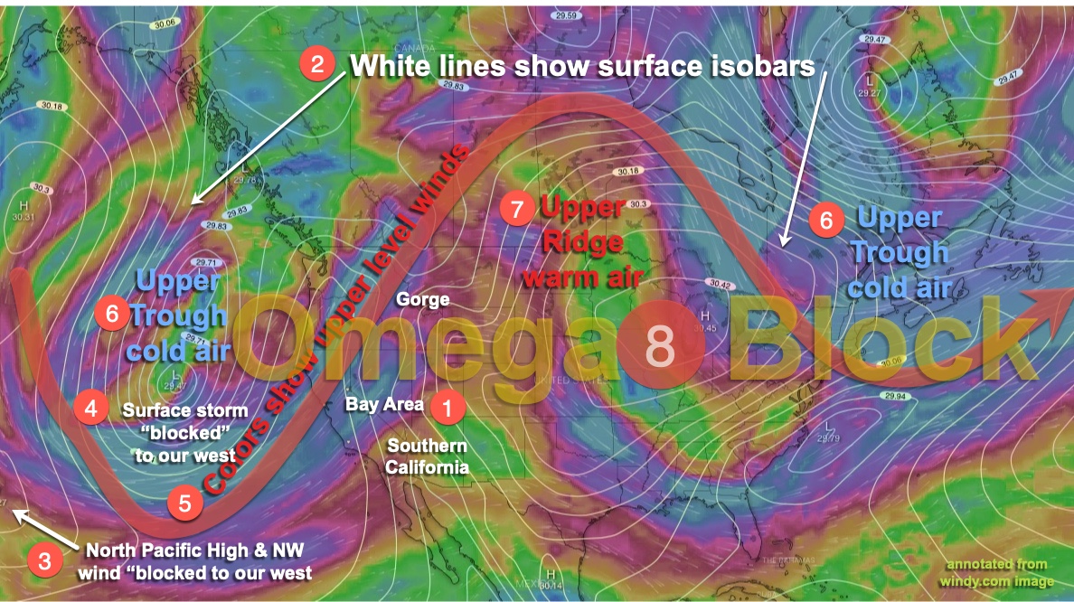
This symbol, omega, is the last letter of the Greek alphabet and a famous watch brand. But in meteorology, it is the shape of the omega symbol, written in our upper-level winds, that has locked most of the west coast into a weather pattern with little day to day change. Specifically, it has given the Gorge mostly blue skies while depriving the San Francisco Bay Area of NW clearing winds. While Southern California has sometimes benefited from mild NW winds curving into the beaches.
Take a look at the brightest colors in the image below and look for an “omega” pattern in the winds at ≈ 18,000 ft. When this pattern of upper level ridges and troughs develop it largely blocks the normal movement of weather from West to East.
Let’s take a look at this diagram step by step.
- First find Southern California, Bay Area and the Gorge.
- Notice the isobar white lines. They represent the surface pressure at different locations.
- Now notice the large storm off the west coast. It has been locked near that location for many days and has barely impacted our weather.
- Then note how far the North Pacific High is from the Baja and California coast. Not much chance of NW wind on our coast!
- The thick red line accentuates the Omega shape of the upper-level winds.
- Notice how the upper troughs make up the”arms” of the Omega Block.
- And between the 2 upper troughs, there is an upper ridge. Voilà, an Omega Block!
Once this type of block sets up it is slow to change and is keeping the North Pacific High from moving up and towards the west coast. It also makes for boring forecasting since things change little from day to day. Notice how this block does not have a perfect Omega shape and it slowly breaks up the next 4-5 days. As this happens my guesscast is that Southern California will see building NW winds Thursday while the Bay Area has to wait until Sunday or Monday.