Even when the victor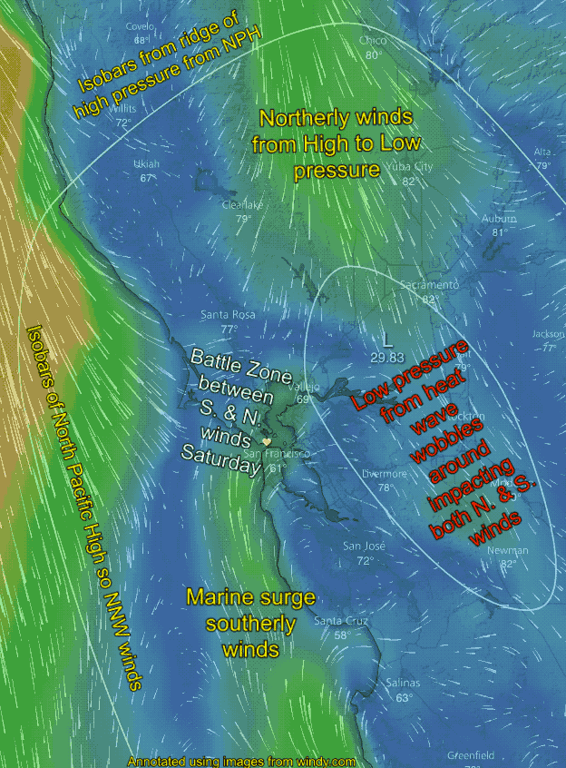 of a battle is preordaine the timing is difficult!
There is a reason the forecasts have been wishy-washy about the timing and strength of the upcoming marine surge Saturday or Sunday. We will be in for a wind battle midday Saturday and while the marine surge is the ultimate winner the time of the victory is unclear!
Looking at the image below you can see that the isobars of the North Pacific High are at an angle to our coast and then lean inland north of the Bay Area. The angle of the isobars makes the ocean winds more NNW rather than NW which favors formation of an eddy. And having isobars angled across the Central Valley makes for NORTH wind in the valley.
The same ridge plus having an upper-level ridge at about 18,000 ft. feet makes for a heat wave so the Central Valley thermal low expands towards the Bay Area. You can see this in the oval of low pressure just east of the Bay Area in the image.
This low pressure creates a pressure gradient from South to North from Southern California hence the SOUTHERLY ocean winds you see south of the Golden Gate. Saturday this cool foggy air is trying to flow through gaps in the Bay Area coast range to get to that low pressure which would really jazz up sites that like southerly winds. But to get to those sites the marine surge southerly winds have to battle the northerly wind you see in the image.
Unfortunately, the low pressure creating this battle tends to wobble about which makes the distribution of the N. and S. winds hard to forecast.
To makes things more complex this battle is actually a 3D battle as NNE and S. winds also battle aloft over the Bay Area Saturday. For lots of reasons the marine surge ultimately will win the battle but I am still wishy-washy about the timing.