Last week there was somewhat atypical weather and winds for the San Francisco Bay Area, Southern California and the Columbia River Gorge.
The Gorge saw very frequent blue skies and warm dry air plus westerly winds. Southern California saw many days of strong NW wind that curved into the coast. While San Francisco saw a summer-type marine layer and wind patterns. And for all 3 locales, these atypical wind patterns continued for days during a time of year, spring, where frequent weather change is the general rule.
In the first half of this animation shows an unusually large North Pacific High has been shoved northward towards the Gulf of Alaska with a lobe of high pressure positioned along the entire west coast of the USA. Notice how the isobars representing the pressure distribution are tightly stacked over the Gorge and Southern California.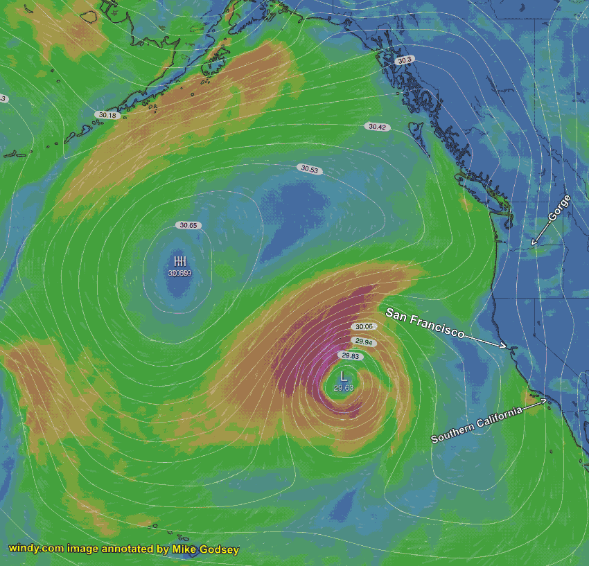
Also notice the rainy surface storm about 1000 miles west of San Francisco. If you were just watching these surface events you puzzled when they were almost locked in place for days in late March and early April. With these features hardly changing from day to day the wind pattern was atypical and static.
Normally weather patterns progress from west to east in a pretty predictable fashion leading to wind and weather changes. So what caused this weather traffic jam?
The answer to this is revealed in the second half of the animation which shows the winds at around 18,000 feet. The winds at this level are critical in forming and steering surface wind and weather patterns. The upper ridge you see in the image are responsible for the warm Gorge weather. But the key to the “traffic jam” is the counterclockwise spinning winds of the upper Cut-Off low.
As you can see this Cut-Off low is mostly disconnected from the rest of the upper-level winds in the image. This means the Cut-Off low stops being moved from west to east. And this means that at the surface the North Pacific High and the lobe of high pressure near California and the surface storm below the Cut-Off low all become fairly stationary. So the Gorge stays warm, sunny and windy. The San Francisco Bay Area kept seeing fog due to the SW winds just aloft. While Southern California keeps seeing days of strong NW wind curving to the beaches.
Today, April 8, the Cut-Off low is shrinking fast so the weather and winds are finally changing. The Gorge is cool and the winds are focused more in the eastern Gorge like a normal spring day. The fog is mostly gone in the Bay Area and the winds are more spring-like from the NW. And the Southern California winds are slowly moving away from a consistent NW pattern.