 Leo and Cabrillo are spared for different reasons.
Hey Mike,
Long time no talk. Hope all is well and you’re having a great summer. I thought I’d share a weather thought from today’s very strong winds for Leo Carrillo.
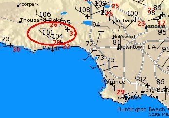
I’m not at the beach today (too much weekend madness for my tastes), but checking the graphs I find it really interesting to have intensive heat at the nearby ridge tops in Malibu, perhaps record breaking, yet no heat bubble at Leo. I’ve never seen this happen before that I can recall. Attached is the mesowest region map from 3:45pm 06/25. History always shows that when temps go over 100 in this zone, the beach is impacted by the heat expanding to the coast, yet the coast is still 73deg at the NWS sensor and 65deg at the iWS sensor. Maybe it will still happen later in the afternoon, but it sure seems strange and inconsistent to past personal observations.
It’s always a guessing game for me in trying to figure this out.
Thanks for listening – stay well!
Mitch K
by Mike Godsey, Mike AT iwindsurf.com
Hi Mitch,
Good to hear from you and thanks for the informative mail.
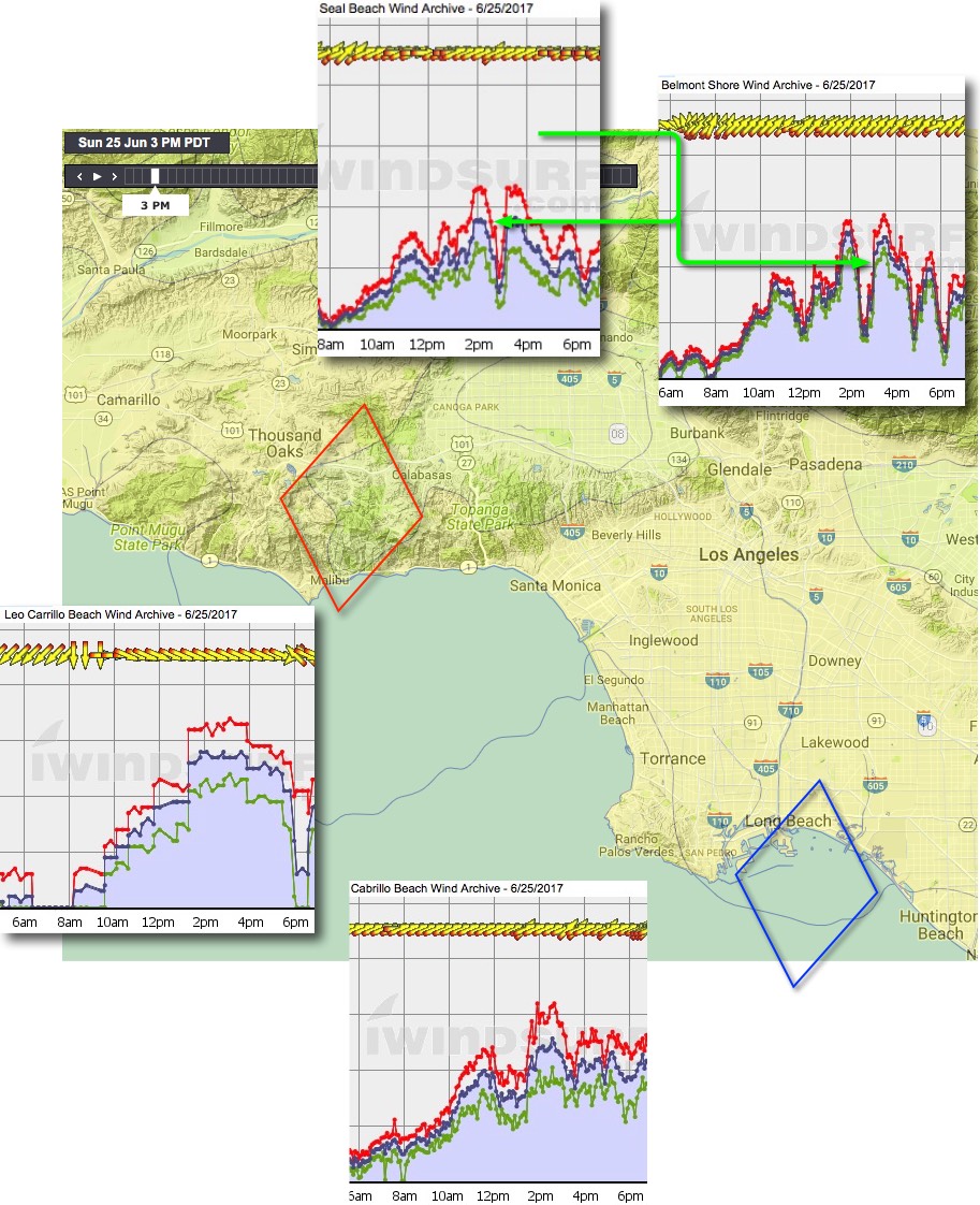
It is rare for me to forecast such strong winds at Leo. Pre dawn I was watching the temperature forecasts for inland valley sites near Leo that suggested that the heat bubble would be an issue for parts of the coast. In the image below notice how the isobars from the thermal low expanded over the Belmont to Seal area. In reality the pressures probably flow back and forth over the beaches in that area as the cooling ocean wind and the land heat interact. You can see that in the Belmont to Seal wind graphs where the impact of the heat bubble is indicated by the green arrows.
But I know from experience that in most thermal trough (aka “heat bubble”) situations Cabrillo is somewhat protected since the Palos Verdes Peninsula is surrounded by cooling water on 3 sides. So its wind graph looks much better.
As your images shows 104 is clearly in the range that would could the heat bubble over Leo. But I reasoned that:
1. The ridges behind the Leo area will slow the expansion of the heat bubble to the beaches so it might not close down the wind until very late afternoon.
2. With such strong winds at Leo the heat bubble would have a hard time getting the last mile to the beach.
3. The forecast inland winds were more W. and not pushing the heat bubble towards Leo
So I gambled and forecast Leo to have very strong wind without a heat bubble effect until evening when the fading winds would allow the bubble to cover the beach. You can see in the Leo wind graph this is pretty much what happened.
Win some, lose some… but this was a win!
Mike