
by Mike Godsey, mikeATiwindsurf.com
Sometimes you will notice a caveat in the forecast that a band of high clouds streaming from SW or WSW may come over us and spoil the wind but stopping the inland valleys from heating weakening the local pressure gradient.
Usually when I mention clouds I am talking about low-level clouds that are often extremely difficult to forecast so I will use weasel words like “Upper-teens winds IF the clouds do not block heating in the inland valleys” Since these clouds form locally or nearby they often develop and move over the valleys after the forecast is published.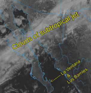
Whereas, when I am talking about the higher clouds of the subtropical jetstream I am much more confident about their impact on the winds. This is because these clouds are in a narrow band extending for hundreds of miles and their location later in the day is far easier to gauge.
This animation of the satellite imagery for Dec. 4, 2019, shows these clouds of the jet completely missing La Ventana and Los Barriles today. Hence the upper-teens or stronger winds.
Now, Thursday Dec. 5, those clouds are much closer to La Ventana making the mid to upper-teens forecast iffy since these clouds may kill the pressure gradient to the inland valleys.