H Naga…62 asked: “I read Mike’s latest article on how the eddy is formed off GG with interest. What I did not quite get is the southerly coastal wind. Are the causes 1) the coastline sloping SE-NW and 2) coastal ridges?”
Hi H Naga… 62! The short answer to your question is that both 1 & 2 above play a role in both our normal winds and in the eddy southerly coastal winds. But to understand the causation of eddies you have to look at the wind direction and the location of low pressure.
Normally in summer we mostly have NW winds on the Northern California coast. In this case 1 & 2 above help accelerate the NW ocean winds near the coast. But eddies form when the winds over the coast clock from NW to more NNW to NE.
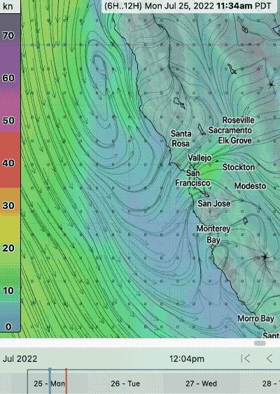
This blog tells how tiny, large and huge eddies form in a simplified manner using text and imagery.
A. How tiny eddies form:
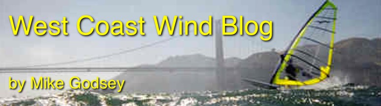
For tiny eddies in the area between Stinson Beach and around Pacifica south of San Francisco, the causation is pretty simple.
- The North Pacific High’s isobars in the late spring to mid-summer are typically roughly parallel to the Northern California coast. In an eddy pattern, upper-level events cause the NPH to push a ridge into far Northern California. This makes its isobars angle into that part of the state making the near-surface winds north of the Golden Gate NNW to NNE. The coast range disrupts this wind flow at the surface but you can usually see this flow in the models and on hilltop sensors.
- This flow over the coast range causes wind shear and a very local lobe of low pressure develops over the Marin county coast creating a South to North pressure gradient in the waters outside the Golden Gate.
- This causes the North Pacific High’s surface NW winds near the coast to curve W then SW then S as they turn towards the low pressure creating a tiny eddy. This counter-clockwise spinning eddy brings southerly winds to the ocean coast in this area. The models are pretty good at picking up this eddy in the early morning and if the marine layer clouds are deep enough you can see it in the satellite imagery and in the sensors along the coast in that area out to the San Francisco ocean buoys.
- How tiny eddies die: Typically the NNW to NNE winds just aloft begin fading in the afternoon so the eddy begins shrinking as the S. to N. pressure gradient disappears. Meanwhile, if the NW ocean winds are strong they also blow the eddy apart as they move to the coast. However, if the northerly winds continue in the afternoon and/or the NW ocean winds are weak the eddy may endure which may help winds in the Blunt Point to Pt. Isabel zone and hinder the winds at 3rd. Ave. winds inside.
B. How larger eddies form that span the waters from about Bodega to about Half Moon Bay.
- The North Pacific High pushes a ridge into most of Northern California. And just aloft N to NNE winds blow from the interior over the Sonoma, Marin and San Francisco counties.
- This encourages the Central Valley thermal low to expand miles over the Marin and Sonoma coast even to our ocean buoys.
- This sets up a larger South to North pressure gradient and a much large longer lasting eddy develops from about Half Moon Bay to past Bodega creating southerly coast winds in that entire area despite NW winds west of the eddy. This larger eddy often lasts all day unless the NW ocean winds are especially strong. This pattern causes strong winds from Blunt Point to Pt. Isabel to Sherman Island and often leaves Crissy and the entire buried in fog and weak winds.
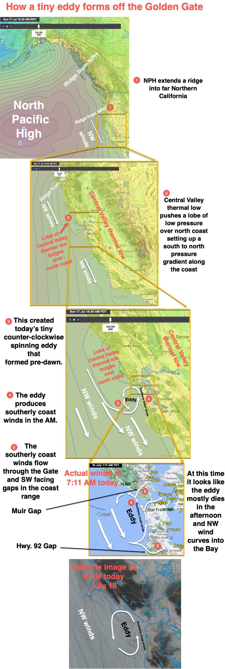
- How larger eddies die: The image with the yellow text shows a larger eddy dying as it is crushed against the Marin and San Francisco coast by the NW wind.
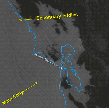
C. How huge eddies form that may span the entire Northern California and sometimes even much of the Central California coast.
- These develop when the North Pacific High pushes a ridge over much of Northern California and the Pacific Northwest so NNE to NE winds develop over the California interior and coast range both near the surface and well aloft. This causes a huge area of low pressure to expand way over the coast north of the Golden Gate. This much larger low-pressure area stirs up an elongated huge eddy that can be several hundred miles wide and even longer down the coast.
- These huge eddies typically endure several days and usually have support from counter-clockwise spinning winds aloft sometimes to over 6000 feet. So it really is a low-pressure area induced by a coastal eddy and looks a bit like a weak storm off the coast. Sites from the north tower of the Golden Gate to Pt. Isabel to Sherman Island blow for days during a giant eddy and Sherman may blow from dawn to dusk and even all night.
- How giant eddies die: Typically these giant eddies die as the Central Valley thermal low slowly moves inland. The NW ocean winds then slowly tear the eddy apart.
What do eddies do to our wind. All of these eddies tend to deepen the marine layer and favor kiteboarding/windsurfing/winging sites that have a gap in the coast range open to the SW and a favorable pressure gradient pathway through East Bay hills.
For example, eddy flow through the Golden Gate with a strong pressure gradient towards Sacramento favors Pt. Isabel and Sherman Island.
While an eddy with a strong pressure gradient towards Bakersfield via San Jose and the Pacheco Pass can cause the southerly coast winds to actually flow through the NW facing San Bruno Gap and curve into WNW winds as they near the 3rd. Ave. channel.
This last image shows how a pressure gradient towards Stockton and especially
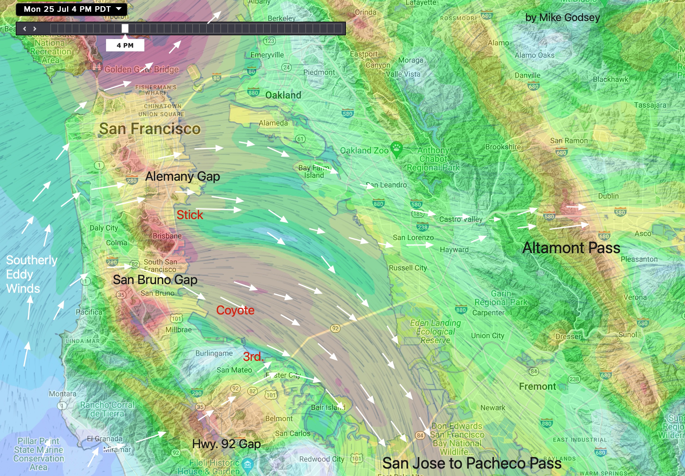
towards Bakersfield impacts an eddies southerly coast winds. in the Candlestick to Coyote and 3rd. Ave. to Palo Alto area.