Hi fxop,
Great question!
For a quick answer to your question about Kerry’s forecast, skip to the bottom.
To really understand what is happening, here is some background.
Palo Alto is less prone than 3rd. Ave. to that battle between the “Good” wind and the “Bad wind” that can spoil the winds in the sail/kite/wing area, especially at the launch.
The forces behind the “Good Wind” are:
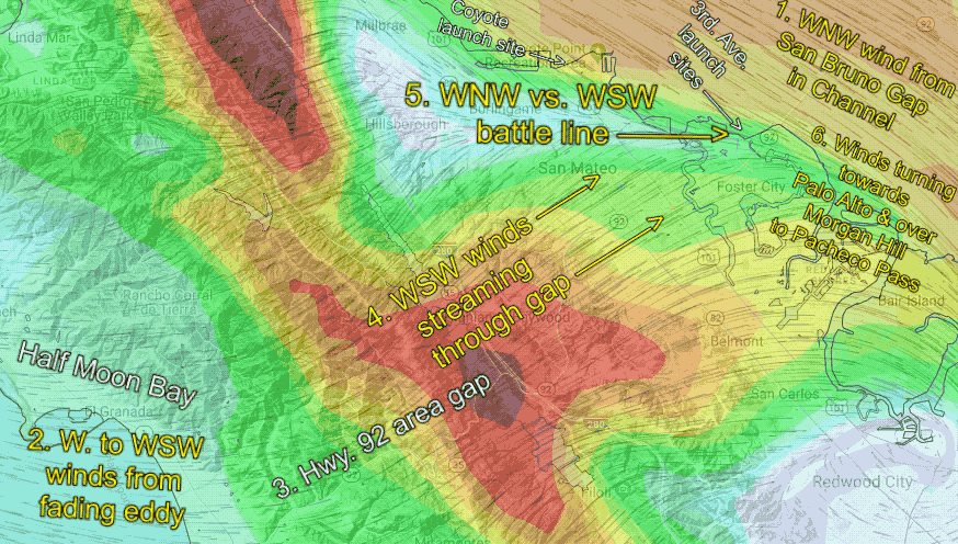
1. NW to WNW ocean winds which push wind through San Bruno Gap towards 3rd & PA
2. At least a moderate pressure gradient towards Bakersfield via Morgan Hill to Pacheco Pass, which sucks and accelerates the San Bruno Gap winds to the launches at 3rd & PA.
The forces behind the “Bad Wind” are:
1. Anything that promotes southerly ocean winds in the Half Moon Bay to Hwy. 92 Gap area to near 3rd. Ave. or Palo Alto. This includes an eddy, a marine surge, or a very deep marine layer.
2. A pressure gradient towards Stockton via the Altamont and Dresser Passes. This gradient does two things.
A. It tries to curve the wind WNW away from shore at 3rd. Ave., as they turn towards those East Bay, passes.
B. It accelerates the WSW wind in the Hwy. 92 Gap area, so it gets closer or even over Palo Alto and 3rd. Ave. launch areas.
All this means there is sometimes a battle between the NW/WNW “Good Wind” and the WSW “Bad Wind” very close to the launch sites.
If the southerly ocean winds weaken or if the pressure gradient towards Stockton weakens during the afternoon, that battle happens west of Palo Alto and 3rd. Ave., so at the launch sites, all you notice is the “Good Wind.”
If the southerly ocean winds weaken or if the pressure gradient towards Stockton weakens during the afternoon, that battle happens west of Palo Alto and 3rd. Ave., so at the launch sites, all you notice is the “Good Wind.”
If the southerly ocean winds become stronger or if the pressure gradient towards Stockton builds during the afternoon, that battle between the “Good Winds” and the “Bad Winds” happens right over Palo Alto and 3rd. Ave., so at the launch sites, you notice unreliable changing winds at the launch despite usable winds outside.
And if the pressure gradient towards Bakersfield fades, then there are WSW “Bad Winds” both at the launch sites and outside.
All these variables can change during the day, making for a forecasting nightmare.
The imagery below shows some of the above.
So, to answer your question:
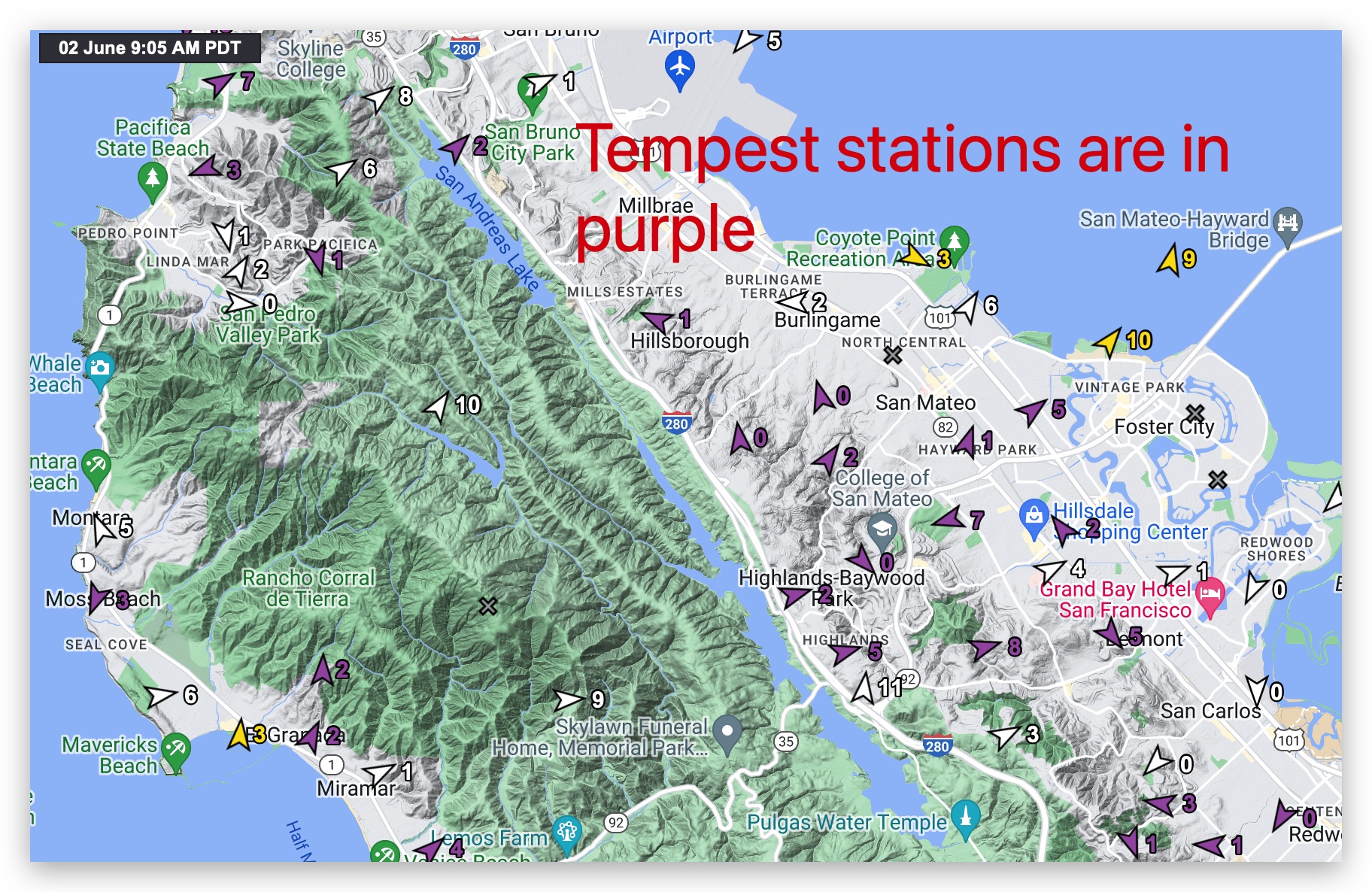
We run a custom 1 km version of the WRF model, which is enhanced to capture the Bay Area topography. The forecasters fine-tune the 3rd. Ave. and Palo Alto model forecasts by looking at the reality before the morning and mid-day forecasts. We look at the direction of ocean winds, the actual wind direction and strength in those passes, the actual pressure gradient and the fog flow in those passes. If we have time, we also look at all of our Tempest weather stations between Half Moon Bay and the launch sites. We do this fully aware that all of this can change between the forecast time and your launch time.
Meanwhile, our Denver modeling office is busy developing machine-learning algorithms to incorporate sensor data into the model and human forecast. We can do this because we have over 60,000 of our Tempest weather stations installed and they are all feeding data into our servers in near real-time. The system will take years to become fully operational.
But I suspect that that sudden shift you noticed in Kerry’s forecast tables from “Good Wind” to the “Bad Wind” was generated by a combo of human pattern recognition and machine learning modifying the forecast table.
I hope all this helps some.
ChatGPT
weatherflow.com
iwindsurf.com
ikitesurf.com
sailflow.com
fishweather.com
USAfishing.com
https://windnotes.smugmug.com